METAR & TAF 55S
55S does not publish a METAR.
Showing the nearest reporting station: KPLU (PIERCE COUNTY/THUN FLD) · 39.1 NM away. Conditions at 55S may differ.
METAR · KPLU
Observed 02:35Z
KPLU 240235Z AUTO 00000KT 9SM CLR 30/09 A2999 RMK AO2
- Wind
- 000° @ 0 kt
- Visibility
- 9 SM
- Temp / Dew
- 30°C / 9°C
- Altimeter
- 29.99 inHg
- Clouds
- CLR
- Density alt
- 3,024 ft
- Ceiling
- Unlimited
- Rules
- VFR
Airport info & contacts
Manager on record, flight service, ARTCC, attendance schedule and pattern altitude — published by the FAA and refreshed every 28 days.
Location
- From city
- 0 NM W
- VFR sectional
- SEATTLE
- ARTCC
- ZSE · SEATTLE
- NOTAM facility
- SEA (NOTAM-D)
Airport manager
- Name
- RUSS MORTON
- Phone
- 360-864-4966
- Address
- 5239 JACKSON HWY, TOLEDO WA 98591-9732
Flight service · Hours
- FSS SEA
- SEATTLE1-800-WX-BRIEF
- Attendance
- Unattended
Frequencies
Tap any row to copy the frequency to your clipboard.
Runways & pattern
Full pagePattern entry · RWY 01
LEFT TRAFFICRunway end performance
| End | TORA | TODA | ASDA | LDA | VGSI | Approach lights | Obstruction |
|---|---|---|---|---|---|---|---|
| 01 | — | — | — | — | — | — | 150', trees, 1152' from thr, 0' R of cntrln, slope 6 |
| 19 | — | — | — | — | — | — | 50', trees, 330' from thr, 83' R of cntrln, slope 2 |
Declared distances in feet. TORA = takeoff run available, TODA = takeoff distance, ASDA = accelerate-stop, LDA = landing distance.
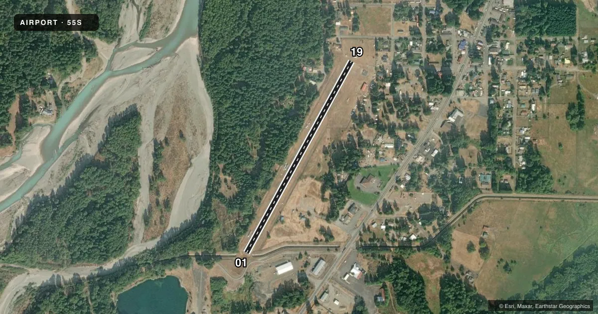
Airport sketch
Runways drawn to scale from FAA survey coordinates, rendered over satellite imagery. Not for navigation.
Approaches & charts
Services on the field
Fuel grades, oxygen, maintenance, ramp storage and lighting — as declared to the FAA by the airport operator.
Fuel & services
- Fuel
- Not available
- Oxygen (bottled)
- Not available
- Oxygen (bulk)
- Not available
- Airframe repair
- Not available
- Power plant repair
- Not available
Ramp & ground
- Transient storage
- Tie-down
- Landing fee
- No fee published
- Customs
- Not available
- Lighting schedule
- SEE RMK
- Beacon schedule
- SS-SR
- Beacon
- White / Green (civil land)(WG)
- Wind indicator
- Lighted
- Segmented circle
- No
Fuel & FBOs
Cheapest 100LL and Jet A on the field and nearby. Always confirm with the FBO before taxi.
Airport notes
Surface conditions, obstructions, local procedures, lighting outages and other notes published with each FAA cycle.
General notes
- TREES AND BLDGS IN TRANSITIONAL SURFACES.
- TREES & FENCES IN PRIM SFC.
- FOR CD CTC SEATTLE ARTCC AT 253-351-3694.
Lighting notes
- ACTVT RWY 01/19 MIRLS - CTAF
Runway surface & condition
- 01/19RWY 01/19 SOFT SHOULDERS BOTH SIDES; USE RWY FOR BACK TAXI TO N END.
Approach & departure obstructions
- 01RWY 01 FENCE AT 64 FT FM THR AND 67 FT L, FENCE AT 60 FT R AND -5 FT DITCH AT 125 FT FM THR.
Other notes
- EXISTED PRIOR TO 1959.
VFR map & nearby airports
VFR sectional. Tap any ICAO chip to open that airport.
Key facts · 55S
Answer card- ICAO
- 55S
- Name
- PACKWOOD
- Location
- PACKWOOD, WASHINGTON
- Elevation
- 1,057 ft MSL
- Traffic pattern altitude
- 2,057 ft MSL (1,000 AGL)
- Control tower
- Non-towered (use CTAF)
- Total runways
- 1
- Longest runway
- 01/19 · 2,357 ft
- Published ILS approaches
- 0
- Published frequencies
- 1
- Magnetic variation
- 20°
- Current flight rules
- VFR
- Current wind
- 000° at 0 kt
- Favored runway now
- –
Packwood Airport sits in Packwood, Washington. The field elevation is 1,057 ft MSL. It has one runway, 01/19, which is 2,357 ft long and asphalt. There is no control tower. CTAF is 122.9. No ILS approaches are published here.
The published pattern altitude is not listed, so use the standard 1,000 ft AGL for light piston operations unless the current Chart Supplement says otherwise. That puts the pattern at about 2,057 ft MSL. The runway has medium intensity lights that are activated by CTAF. Published remarks also note soft shoulders on both sides of 01/19. Use the runway for back taxi to the north end. Runway 01 has a fence close to the threshold, with more fence and a ditch beyond it. Trees and fences are in the primary surface. Trees and buildings are in the transitional surfaces.
There are no on-field FBOs listed. Check with the airport operator or the FBO directly by phone before arrival if you need fuel or services. For clearance delivery, contact Seattle ARTCC at 253-351-3694. This is a small field with terrain and obstacle details that matter. Review the current Chart Supplement before you go, especially if you plan a night arrival or a heavier airplane.