METAR & TAF KESW
KESW does not publish a METAR.
Showing the nearest reporting station: KELN (BOWERS FLD) · 29.9 NM away. Conditions at KESW may differ.
METAR · KELN
Observed 05:53Z
KELN 270553Z AUTO 31014KT 10SM FEW100 18/10 A3002 RMK AO2 PK WND 31028/0455 SLP156 T01780100 10283 20178 51017
- Wind
- 310° @ 14 kt
- Visibility
- 10 SM
- Temp / Dew
- 18°C / 10°C
- Altimeter
- 30.02 inHg
- Clouds
- FEW
- Density alt
- 2,996 ft
- Ceiling
- Unlimited
- Rules
- VFR
Airport info & contacts
Manager on record, flight service, ARTCC, attendance schedule and pattern altitude — published by the FAA and refreshed every 28 days.
Location
- From city
- 2 NM N
- VFR sectional
- SEATTLE
- ARTCC
- ZSE · SEATTLE
- NOTAM facility
- SEA (NOTAM-D)
Airport manager
- Name
- JOHN WILSON
- Phone
- 360-618-2477
- Address
- PO BOX 47312, OLYMPIA WA 98504-7264
Flight service · Hours
- FSS SEA
- SEATTLE1-800-WX-BRIEF
- Attendance
- Unattended
Frequencies
Tap any row to copy the frequency to your clipboard.
Runways & pattern
Full pagePattern entry · RWY 27
LEFT TRAFFICRunway end performance
| End | TORA | TODA | ASDA | LDA | VGSI | Approach lights | Obstruction |
|---|---|---|---|---|---|---|---|
| 09 | — | — | — | — | — | — | 85', trees, 247' from thr, 0' R of cntrln, slope 2 |
| 27 | — | — | — | — | — | — | 50', trees, 140' from thr, 0' R of cntrln, slope 2 |
Declared distances in feet. TORA = takeoff run available, TODA = takeoff distance, ASDA = accelerate-stop, LDA = landing distance.
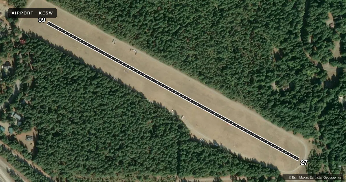
Airport sketch
Runways drawn to scale from FAA survey coordinates, rendered over satellite imagery. Not for navigation.
Approaches & charts
Services on the field
Fuel grades, oxygen, maintenance, ramp storage and lighting — as declared to the FAA by the airport operator.
Fuel & services
- Fuel
- Not available
Ramp & ground
- Transient storage
- Tie-down
- Landing fee
- No fee published
- Customs
- Not available
- Lighting schedule
- SEE RMK
- Wind indicator
- Yes
- Segmented circle
- No
Fuel & FBOs
Cheapest 100LL and Jet A on the field and nearby. Always confirm with the FBO before taxi.
Airport notes
Surface conditions, obstructions, local procedures, lighting outages and other notes published with each FAA cycle.
General notes
- CLSD 1 OCT - 1 JUN; EXC APVD MIL & PUBLIC SAFETY/LAW ENFORCEMENT HELI OPS.
- PAEW & WILDLIFE ON OR INVOF RWY.
Lighting notes
- LGTS OPER ON PCL ONLY ON DAYS ARPT IS OPEN.
Runway surface & condition
- 09/27ACTVT LIRL RWY 09/27 - CTAF.
Other notes
- ESTABD PRIOR TO 15 MAY 1959.
- PILOTS PROVD TIEDOWN CHAINS.
VFR map & nearby airports
VFR sectional. Tap any ICAO chip to open that airport.
Key facts · KESW
Answer card- ICAO
- KESW
- Name
- EASTON STATE
- Location
- EASTON, WASHINGTON
- Elevation
- 2,226 ft MSL
- Traffic pattern altitude
- 3,226 ft MSL (1,000 AGL)
- Control tower
- Non-towered (use CTAF)
- Total runways
- 1
- Longest runway
- 09/27 · 2,640 ft
- Published ILS approaches
- 0
- Published frequencies
- 1
- Magnetic variation
- 20°
- Current flight rules
- VFR
- Current wind
- 310° at 14 kt
- Favored runway now
- RWY 27
Easton State Airport sits in Easton, Washington. The field elevation is 2,226 ft MSL. It has one runway. Runway 09/27 is 2,640 ft of turf, so plan for short-field performance and soft-field technique. There is no control tower. CTAF is 122.9.
No ILS approaches are published here. Pattern altitude is not published, so use the current FAA Chart Supplement before you go. The airport is closed from 1 October through 1 June except for approved military and public safety or law enforcement helicopter operations. That matters for planning. The runway lights are pilot-controlled only when the airport is open. The lighting for runway 09/27 is activated by CTAF.
There are no on-field FBOs listed. Bring your own tiedown chains. Wildlife is reported on or near the runway, so keep a sharp scan on rollout and on departure. With the field sitting above 2,200 ft MSL, density altitude can be a factor on warm days. Check performance carefully before you launch or accept a landing distance that leaves no margin.