METAR & TAF 21W
21W does not publish a METAR.
Showing the nearest reporting station: KPLU (PIERCE COUNTY/THUN FLD) · 31.3 NM away. Conditions at 21W may differ.
METAR · KPLU
Observed 04:15Z
KPLU 270415Z AUTO 00000KT 10SM -DZ BKN029 OVC075 17/15 A3009 RMK AO2
- Wind
- 000° @ 0 kt
- Visibility
- 10 SM
- Temp / Dew
- 17°C / 15°C
- Altimeter
- 30.09 inHg
- Clouds
- OVC
- Density alt
- 3,315 ft
- Ceiling
- 2,900 ft AGL
- Rules
- MVFR
Airport info & contacts
Manager on record, flight service, ARTCC, attendance schedule and pattern altitude — published by the FAA and refreshed every 28 days.
Location
- From city
- 10 NM SE
- VFR sectional
- SEATTLE
- ARTCC
- ZSE · SEATTLE
- NOTAM facility
- SEA (NOTAM-D)
Airport manager
- Name
- JOHN WILSON
- Phone
- 360-618-2477
- Address
- PO BOX 47312, OLYMPIA WA 98504-7264
Flight service · Hours
- FSS SEA
- SEATTLE1-800-WX-BRIEF
- Attendance
- Unattended
Frequencies
Tap any row to copy the frequency to your clipboard.
Runways & pattern
Full pagePattern entry · RWY 15
LEFT TRAFFICRunway end performance
| End | TORA | TODA | ASDA | LDA | VGSI | Approach lights | Obstruction |
|---|---|---|---|---|---|---|---|
| 15 | — | — | — | — | — | — | 100', trees, 1406' from thr, 0' R of cntrln, slope 12 |
| 33 | — | — | — | — | — | — | 75', trees, 965' from thr, 0' R of cntrln, slope 10 |
Declared distances in feet. TORA = takeoff run available, TODA = takeoff distance, ASDA = accelerate-stop, LDA = landing distance.
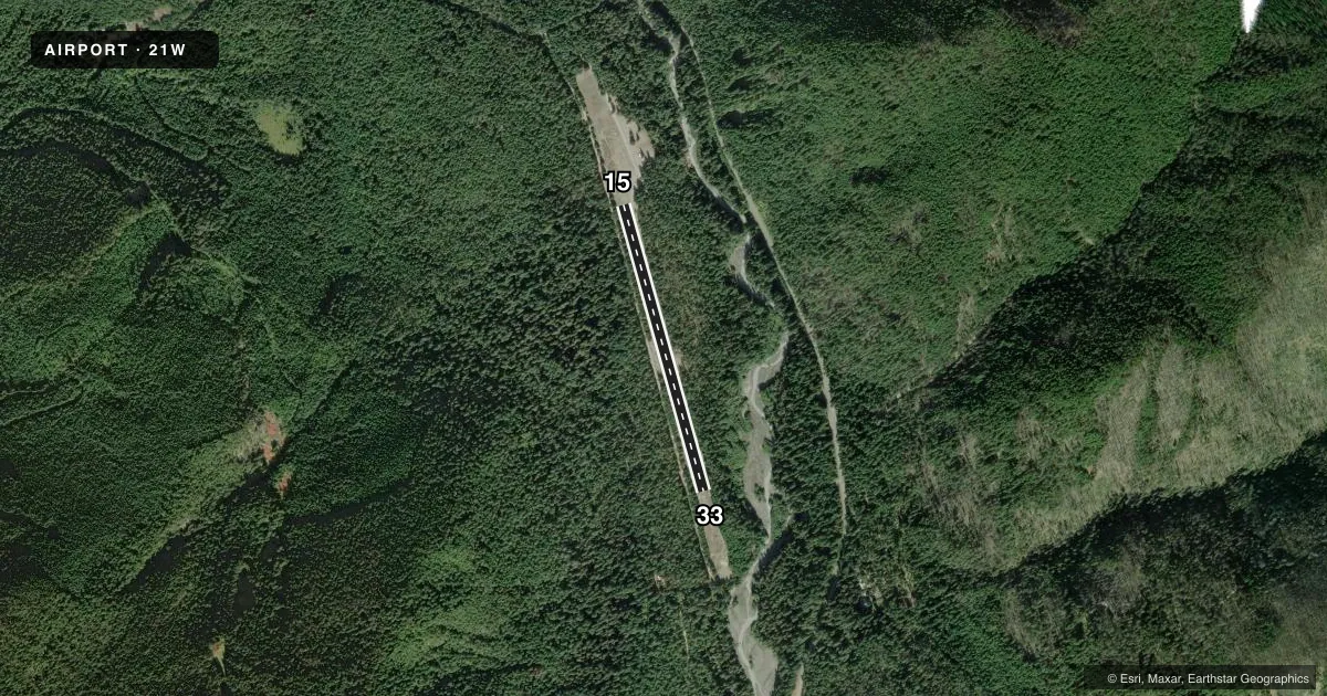
Airport sketch
Runways drawn to scale from FAA survey coordinates, rendered over satellite imagery. Not for navigation.
Approaches & charts
Services on the field
Fuel grades, oxygen, maintenance, ramp storage and lighting — as declared to the FAA by the airport operator.
Fuel & services
- Fuel
- Not available
Ramp & ground
- Transient storage
- Not published
- Wind indicator
- Yes
- Segmented circle
- No
Fuel & FBOs
Cheapest 100LL and Jet A on the field and nearby. Always confirm with the FBO before taxi.
Airport notes
Surface conditions, obstructions, local procedures, lighting outages and other notes published with each FAA cycle.
General notes
- CLSD 1 OCT TO 1 JUN EXC FOR APPROVED MIL & PUBLIC SAFETY/LAW ENFORCEMENT HELI OPS.
- VEHICLES, PEDESTRIANS, & ANIMALS ON & INVOF RY.
- USFS CAMPGROUNDS E & N OF RY.
- GUARDRAIL AND ROAD RUNS FULL LEN OF EASTSIDE OF RWY.
- CTN: MOUNTAINOUS TRRN SURROUNDS ARPT.
Approach & departure obstructions
- 15RWY 15 2 FT SIGN, 45 FT R & 11 FT FM THR; 65 FT TREES 87 FT R; GUARDRAIL & ROAD 55 FT L; 2 FT SIGN 45 FT L & 11 FT FM THR.
- 33HAS ROAD, GUARD & +95 FT TREES 90 FT R OF CNTRLN & 80 FT TREES 84 FT L OF CNTRLN. 2 FT SIGNS, 35 FT R & 43 FT L & 11 FT FM THR.
VFR map & nearby airports
VFR sectional. Tap any ICAO chip to open that airport.
Key facts · 21W
Answer card- ICAO
- 21W
- Name
- RANGER CREEK
- Location
- GREENWATER, WASHINGTON
- Elevation
- 2,650 ft MSL
- Traffic pattern altitude
- 3,650 ft MSL (1,000 AGL)
- Control tower
- Non-towered (use CTAF)
- Total runways
- 1
- Longest runway
- 15/33 · 2,875 ft
- Published ILS approaches
- 0
- Published frequencies
- 1
- Magnetic variation
- 19°
- Current flight rules
- MVFR
- Current wind
- 000° at 0 kt
- Favored runway now
- –
Ranger Creek (21W) sits near Greenwater, Washington at 2,650 ft MSL. It has one runway, 15/33, which is 2,875 ft long and asphalt. There is no control tower. CTAF is 122.9. No ILS approaches are published here. The pattern altitude is not published, so use 3,650 ft MSL for the standard 1,000 ft AGL pattern unless the current Chart Supplement says otherwise.
This is a mountain airport. Terrain surrounds the field, so plan your arrival with extra margin and expect a more demanding environment than a lowland strip. Published remarks also call out vehicles, pedestrians and animals on or near the runway. The east side of the runway has a road and guardrail running the full length. Runway 33 has trees, a road and a guardrail close to the approach end. Runway 15 also has signs, trees, a road and a guardrail near the threshold.
The airport is closed from 1 October to 1 June except for approved military and public safety or law enforcement helicopter operations. There are no on-field FBOs listed. Check the current FAA Chart Supplement and contact the airport operator before planning a stop here, especially if you need current access details or seasonal status confirmation.