METAR & TAF S36
S36 does not publish a METAR.
Showing the nearest reporting station: KRNT (RENTON MUNI) · 10.4 NM away. Conditions at S36 may differ.
METAR · KRNT
Observed 06:53Z
KRNT 270653Z AUTO 18004KT 10SM CLR 17/13 A3006 RMK AO2 SLP184 T01720128
- Wind
- 180° @ 4 kt
- Visibility
- 10 SM
- Temp / Dew
- 17°C / 13°C
- Altimeter
- 30.06 inHg
- Clouds
- CLR
- Density alt
- 652 ft
- Ceiling
- Unlimited
- Rules
- VFR
Airport info & contacts
Manager on record, flight service, ARTCC, attendance schedule and pattern altitude — published by the FAA and refreshed every 28 days.
Location
- From city
- 1 NM SSE
- VFR sectional
- SEATTLE
- ARTCC
- ZSE · SEATTLE
- NOTAM facility
- SEA (NOTAM-D)
Airport manager
- Name
- JEFF MILLER
- Phone
- 425-533-9651
- Address
- 29300 179TH PLACE SE, P.O. BOX 7282, COVINGTON WA 98042-7282
Flight service · Hours
- FSS SEA
- SEATTLE1-800-WX-BRIEF
- Attendance
- 0900-1700
Frequencies
Tap any row to copy the frequency to your clipboard.
Runways & pattern
Full pagePattern entry · RWY 16
LEFT TRAFFICRunway end performance
| End | TORA | TODA | ASDA | LDA | VGSI | Approach lights | Obstruction |
|---|---|---|---|---|---|---|---|
| 16 | — | — | — | — | — | — | 76', trees, 901' from thr, 0' R of cntrln, slope 9 |
| 34 | — | — | — | — | — | — | 107', trees, 1560' from thr, 0' R of cntrln, slope 12 |
Declared distances in feet. TORA = takeoff run available, TODA = takeoff distance, ASDA = accelerate-stop, LDA = landing distance.
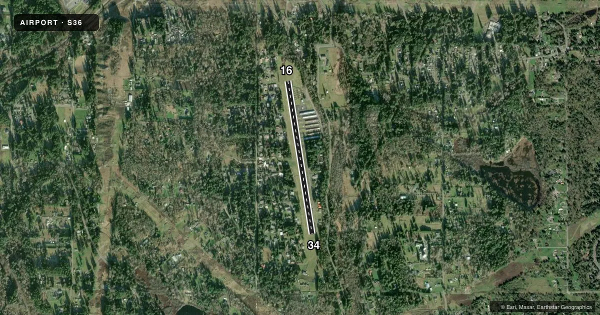
Airport sketch
Runways drawn to scale from FAA survey coordinates, rendered over satellite imagery. Not for navigation.
Approaches & charts
Services on the field
Fuel grades, oxygen, maintenance, ramp storage and lighting — as declared to the FAA by the airport operator.
Fuel & services
- Fuel
- 100LL
- Oxygen (bottled)
- Not available
- Oxygen (bulk)
- Not available
- Airframe repair
- Major
- Power plant repair
- Major
- Other services
- INSTR,RNTL
Ramp & ground
- Transient storage
- Tie-down
- Landing fee
- No fee published
- Customs
- Not available
- Beacon schedule
- SS-SR
- Beacon
- White / Green (civil land)(WG)
- Wind indicator
- Lighted
- Segmented circle
- No
Fuel & FBOs
Cheapest 100LL and Jet A on the field and nearby. Always confirm with the FBO before taxi.
Airport notes
Surface conditions, obstructions, local procedures, lighting outages and other notes published with each FAA cycle.
General notes
- TREES BOTH SIDES OF RWY IN TRSN SFC.
- TREES ON BOTH SIDES OF RWY 15/33.
- NIGHT OPS USE RWY 15, WIND AND WX PMTG.
- ARPT CLSD WHEN SNOW ON RWY.
- FOR CD CTC SEATTLE APCH AT 206-214-4723.
- TGLS PROHIBITED.
Fuel notes
- 100LL24 HR CREDIT CARD FUEL AVBL.
Approach & departure obstructions
- 16TREES IN PRIM SFC, PARKED ACFT IN PRIM SFC BOTH SIDES OF RWY AND 3 FT SIGN, 92 FT LEFT, 27 FT FROM THR.
- 34+95 FT TREES IN PRI SFC 0-200 FT FM THR, 120 FT RIGHT.
- 16MARKINGS FADED.
- 34MARKINGS FADED.
- 1615/33 NSTD MARKINGS NRS & CNTRLN ONLY; FADED.
- 34RWY 33 APPROACH RATIO 6:1 FROM DSPLCD THR.
Other notes
- PILOTS BRING OWN TIEDOWNS.
- MANAGERAMGR OTR CTC: AIRFIELDMANAGER@CRESTAIRFIELD.AERO.
- OWNEROTR CTC: AIRFIELDMANAGER@CRESTAIRFIELD.AERO.
VFR map & nearby airports
VFR sectional. Tap any ICAO chip to open that airport.
Key facts · S36
Answer card- ICAO
- S36
- Name
- CREST AIRFIELD
- Location
- COVINGTON, WASHINGTON
- Elevation
- 472 ft MSL
- Traffic pattern altitude
- 1,472 ft MSL (1,000 AGL)
- Control tower
- Non-towered (use CTAF)
- Total runways
- 1
- Longest runway
- 16/34 · 3,288 ft
- Published ILS approaches
- 0
- Published frequencies
- 2
- Magnetic variation
- 20°
- Current flight rules
- VFR
- Current wind
- 180° at 4 kt
- Favored runway now
- RWY 16
Crest Airfield is in Covington, Washington. The field elevation is 472 ft MSL. It has one runway. Runway 15/33 is 3,288 ft long and asphalt. There is no control tower. CTAF and UNICOM are both 123.0. No ILS approaches are published here.
The pattern altitude is not published. Use 1,000 ft AGL for light piston operations unless the current Chart Supplement says otherwise. Crest Airpark is on the field. It carries 100LL. Twenty-four hour credit card fuel is available. Pilots should plan for trees near the runway environment. Published remarks note trees in the primary and transitional surfaces. They also note trees on both sides of the runway. Runway 33 markings are faded. Runway 15 markings are faded too.
A few operational items matter here. The airport is closed when there is snow on the runway. Touch-and-go landings are prohibited. Night operations use runway 15 when wind and weather permit. For clearance delivery, contact Seattle Approach at 206-214-4723. Bring your own tiedowns. If you are arriving for the first time, review the current Chart Supplement before departure. The runway length is workable for light aircraft. The trees and the published runway notes deserve a careful brief before you go.