METAR & TAF S50
S50 does not publish a METAR.
Showing the nearest reporting station: KSEA (SEATTLE-TACOMA INTL) · 8.1 NM away. Conditions at S50 may differ.
METAR · KSEA
Observed 08:01Z
KSEA 270801Z 21007KT 10SM BKN027 BKN120 OVC240 15/13 A3008 RMK AO2 T01500128 $
- Wind
- 210° @ 7 kt
- Visibility
- 10 SM
- Temp / Dew
- 15°C / 13°C
- Altimeter
- 30.08 inHg
- Clouds
- OVC
- Density alt
- -120 ft
- Ceiling
- 2,700 ft AGL
- Rules
- MVFR
Airport info & contacts
Manager on record, flight service, ARTCC, attendance schedule and pattern altitude — published by the FAA and refreshed every 28 days.
Location
- From city
- 1 NM N
- VFR sectional
- SEATTLE
- ARTCC
- ZSE · SEATTLE
- NOTAM facility
- SEA (NOTAM-D)
Airport manager
- Name
- TIM MENSONIDES
- Phone
- (253) 333-6821
- Address
- 2143 E ST. NE, SUITE #1, AUBURN WA 98002
Flight service · Hours
- FSS SEA
- SEATTLE1-800-WX-BRIEF
- Attendance
- MON-FRI · 0800-1700
Frequencies
Tap any row to copy the frequency to your clipboard.
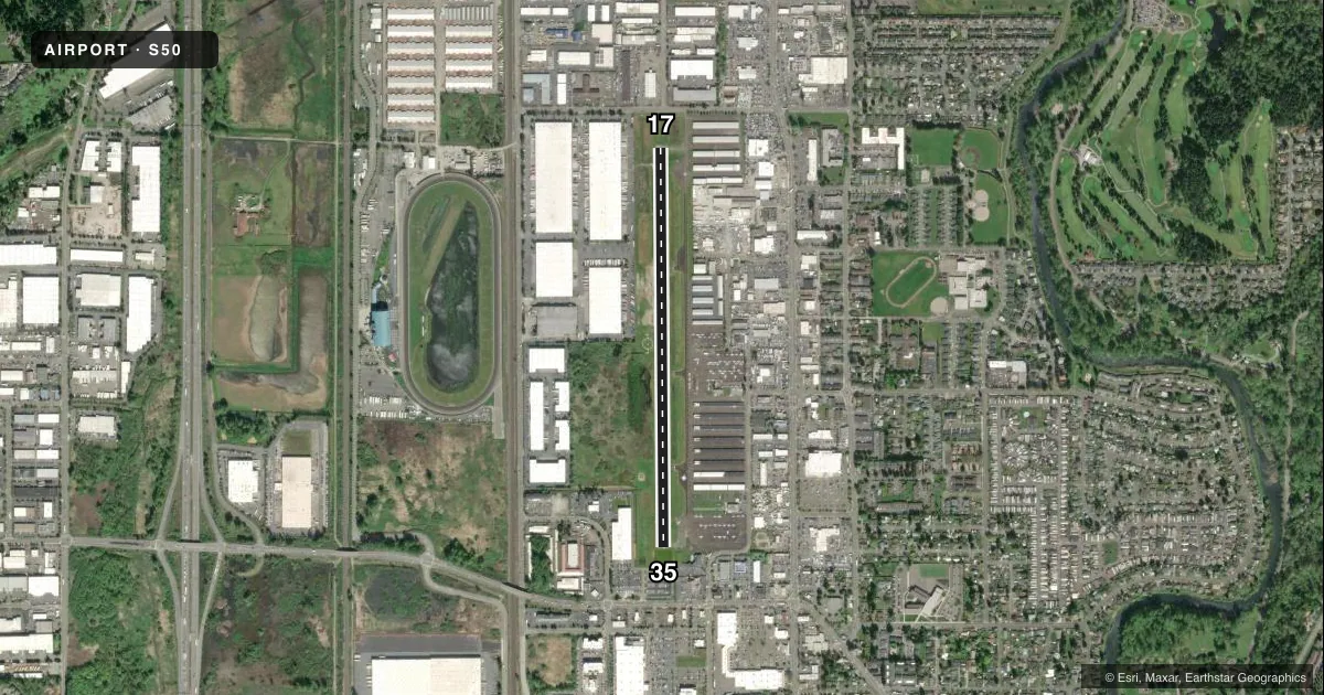
Runways & pattern
Full pagePattern entry · RWY 17
RIGHT TRAFFICRunway end performance
| End | TORA | TODA | ASDA | LDA | VGSI | Approach lights | Obstruction |
|---|---|---|---|---|---|---|---|
| 17 | — | — | — | — | PAPI 2-box left(4°) | — | 25', bldg, 700' from thr, 88' R of cntrln, slope 20 |
| 35 | — | — | — | — | PAPI 2-box right(4°) | — | 18', other, 442' from thr, 0' R of cntrln, slope 13 |
Declared distances in feet. TORA = takeoff run available, TODA = takeoff distance, ASDA = accelerate-stop, LDA = landing distance.
Airport sketch
Runways drawn to scale from FAA survey coordinates, rendered over satellite imagery. Not for navigation.
Approaches & charts
Services on the field
Fuel grades, oxygen, maintenance, ramp storage and lighting — as declared to the FAA by the airport operator.
Fuel & services
- Fuel
- 100LLA
- Airframe repair
- Major
- Power plant repair
- Major
- Other services
- CHTR,INSTR,RNTL,SALES
Ramp & ground
- Transient storage
- Tie-down
- Hangar
- Landing fee
- No fee published
- Customs
- Not available
- Lighting schedule
- SEE RMK
- Beacon schedule
- SS-SR
- Beacon
- White / Green (civil land)(WG)
- Wind indicator
- Lighted
- Segmented circle
- Yes
Fuel & FBOs
Cheapest 100LL and Jet A on the field and nearby. Always confirm with the FBO before taxi.
Airport notes
Surface conditions, obstructions, local procedures, lighting outages and other notes published with each FAA cycle.
General notes
- ULTRALIGHT NA. OTFC OF RESIDENTIAL AREA E OF ARPT NA. TFC PAT INSTRN - AMGR.
- FOR CD CTC SEATTLE APCH AT 206-214-4723.
- BIRDS & WILDLIFE INVOF ARPT.
- CALM WND RWY: 35
- AVOID RWY DLA WHEN PAT ACTV.
- WINTER WX RPT MON-FRI 0800-1700.
- REF ARPT WEBSITE FOR PAT INFO AND NOISE ABATEMENT.
- WX RPRT AVBL, KEY MIC 4 TIMES ON FREQ 122.8.
- PCL AVBL 24/7.
- HEL TOUCHDOWN RUNNING LDG AND TKOFS PROHIBITED ON TWY ALPHA AND RWY 17/35.
Lighting notes
- ACTVT REIL RWY 17 & 35; MIRL RWY 17/35 - CTAF. PAPI RWY 17 & 35 OPR CONSLY.
Approach & departure obstructions
- 35CALM WND RWY.
- 17PAPI UNUSBLE BYD 10 DEGS RIGHT OF CNTRLN.
- 1720:1 APCH SLOPE; 80 FT E-W PWR LINE 1804 FT N OF THR.
- 35CTLG OBSTN PRKG LOT LGT POLES.
VFR map & nearby airports
VFR sectional. Tap any ICAO chip to open that airport.
Key facts · S50
Answer card- ICAO
- S50
- Name
- AUBURN MUNI
- Location
- AUBURN, WASHINGTON
- Elevation
- 63 ft MSL
- Traffic pattern altitude
- 1,063 ft MSL (1,000 AGL)
- Control tower
- Non-towered (use CTAF)
- Total runways
- 1
- Longest runway
- 17/35 · 3,842 ft
- Published ILS approaches
- 0
- Published frequencies
- 4
- Magnetic variation
- 15°
- Current flight rules
- MVFR
- Current wind
- 210° at 7 kt
- Favored runway now
- RWY 17
Auburn Muni sits in Auburn, Washington. The field elevation is 63 ft MSL. It has one runway. Runway 17/35 is 3,842 ft long and paved with asphalt. There is no control tower. Clearance delivery is handled through Seattle Approach. The published frequencies include CTAF and UNICOM on 122.975.
No ILS approaches are published here. The pattern altitude is not published in the facts, so use the standard 1,000 ft AGL unless the current FAA Chart Supplement says otherwise. The on-field FBO is Auburn Municipal Airport. It carries 100LL. Pilot-controlled lighting is available 24 hours a day. Runway end identifier lights are pilot controlled on both ends. Medium intensity runway lights are also on runway 17/35 and are controlled by CTAF. The PAPI on both runway ends operates continuously, though the runway 17 PAPI is unusable beyond 10 degrees right of centerline.
A few local notes matter here. Use runway 35 for calm wind conditions. Avoid runway delay when the traffic pattern is active. Helicopter touchdown running landings and takeoffs are prohibited on taxiway Alpha and runway 17/35. Ultralight aircraft are not authorized. Overflight of the residential area east of the airport is not authorized. Birds and wildlife are also reported in the area, so keep a sharp scan on departure and arrival.