METAR & TAF 2S1
2S1 does not publish a METAR.
Showing the nearest reporting station: KSEA (SEATTLE-TACOMA INTL) · 6.7 NM away. Conditions at 2S1 may differ.
METAR · KSEA
Observed 11:53Z
KSEA 271153Z 19006KT 10SM BKN021 BKN033 OVC085 15/12 A3008 RMK AO2 SLP190 70001 T01500122 10156 20150 51004 $
- Wind
- 190° @ 6 kt
- Visibility
- 10 SM
- Temp / Dew
- 15°C / 12°C
- Altimeter
- 30.08 inHg
- Clouds
- OVC
- Density alt
- 193 ft
- Ceiling
- 2,100 ft AGL
- Rules
- MVFR
Airport info & contacts
Manager on record, flight service, ARTCC, attendance schedule and pattern altitude — published by the FAA and refreshed every 28 days.
Location
- From city
- 1 NM NW
- VFR sectional
- SEATTLE
- Pattern altitude
- 983 ft AGL · 1,299 ft MSL
- ARTCC
- ZSE · SEATTLE
- NOTAM facility
- SEA (NOTAM-D)
Airport manager
- Name
- KEVAN YALOWITZ
- Phone
- 202-641-2050
- Address
- 19710 87TH AVE SW, VASHON WA 98070
Flight service · Hours
- FSS SEA
- SEATTLE1-800-WX-BRIEF
- Attendance
- Unattended
Frequencies
Tap any row to copy the frequency to your clipboard.
Runways & pattern
Full pagePattern entry · RWY 17
RIGHT TRAFFICRunway end performance
| End | TORA | TODA | ASDA | LDA | VGSI | Approach lights | Obstruction |
|---|---|---|---|---|---|---|---|
| 17 | — | — | — | — | — | — | 41', trees, 0' from thr, 78' R of cntrln, slope 0 |
| 35 | — | — | — | — | — | — | 30', trees, 0' from thr, 90' R of cntrln, slope 0 |
Declared distances in feet. TORA = takeoff run available, TODA = takeoff distance, ASDA = accelerate-stop, LDA = landing distance.
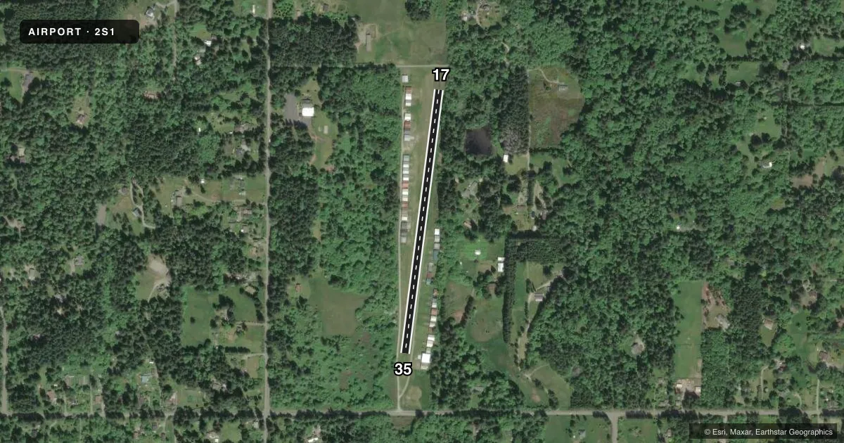
Airport sketch
Runways drawn to scale from FAA survey coordinates, rendered over satellite imagery. Not for navigation.
Approaches & charts
Services on the field
Fuel grades, oxygen, maintenance, ramp storage and lighting — as declared to the FAA by the airport operator.
Fuel & services
- Fuel
- Not available
- Oxygen (bottled)
- Not available
- Oxygen (bulk)
- Not available
- Other services
- INSTR
Ramp & ground
- Transient storage
- Tie-down
- Landing fee
- No fee published
- Customs
- Not available
- Lighting schedule
- SS-SR
- Wind indicator
- Lighted
- Segmented circle
- No
Fuel & FBOs
Cheapest 100LL and Jet A on the field and nearby. Always confirm with the FBO before taxi.
Airport notes
Surface conditions, obstructions, local procedures, lighting outages and other notes published with each FAA cycle.
General notes
- NGT OPNS ONLY FOR PILOTS FAMILIAR WITH APT CLOSE IN OBSTNS, ALL QUADRANTS.
- OCNL LARGE WILD ANIMALS ON ARPT.
- RWY 17/35 SOFT WHEN WET.
- HANGARS 90 FT E & W OF CNTRLN.
- NOISE ABATEMENT PROCS IN EFCT. CTC AMGR 202-641-2050.
- TOUCH & GO LDGS NOT RECOMMENDED.
- TURBULENCE PSBL AT N END OF RY 17/35 WITH STRONG CROSSWINDS.
- RCMD CLG FOR FLD CONDS 202-641-2050.
- HEL PARKING AREA RSTRD TO MEDEVAC OPNS.
- HILL 5-10 FT W OF RWY EDGE THE FULL LEN.
- GATE COMBINATION 1168.
- FOR CD CTC SEATTLE APCH AT 206-214-4723.
Runway surface & condition
- H1FOR MEDIVAC EMERG MED SVCS ONLY.
- 17/35NSTD LIRL; THR LGTS NON-STD COLORS 360 DEG GREEN.
- H1G PERIMETER LGTS.
Approach & departure obstructions
- 17+5 FT FENCE & DIRT RD APRX 182 FT FM THR.
- 35TREES IN PRIM SFC AT THLD; GRAVEL RD 45 FT RIGHT AT THLD.
Other notes
- ESTABD PRIOR TO 15 MAY 1959.
- PILOTS BRING OWN TIEDOWNS.
VFR map & nearby airports
VFR sectional. Tap any ICAO chip to open that airport.
Key facts · 2S1
Answer card- ICAO
- 2S1
- Name
- VASHON MUNI
- Location
- VASHON, WASHINGTON
- Elevation
- 316 ft MSL
- Traffic pattern altitude
- 1,299 ft MSL (983 AGL)
- Control tower
- Non-towered (use CTAF)
- Total runways
- 1
- Longest runway
- 17/35 · 2,001 ft
- Published ILS approaches
- 0
- Published frequencies
- 1
- Magnetic variation
- 20°
- Current flight rules
- MVFR
- Current wind
- 190° at 6 kt
- Favored runway now
- RWY 17
Vashon Muni Airport (2S1) sits on Vashon Island in Washington. The field elevation is 316 ft MSL. It has one runway, 17/35, which is 2,001 ft of turf. The airport is not towered. CTAF is 122.9. Pattern altitude is 983 ft AGL, which is 1,299 ft MSL.
There are no published ILS approaches here. That makes current weather and local terrain awareness more important, especially for a short turf strip with close-in obstructions. Published remarks call out turbulence near the north end of runway 17/35 when crosswinds are strong. They also note a 5-foot fence and dirt road about 182 feet from the threshold of runway 17. Night operations are only for pilots who know the airport and its close-in obstructions in all quadrants. Runway 17/35 has nonstandard low-intensity lights with nonstandard threshold colors. Touch-and-go landings are not recommended.
No on-field FBOs are listed. Check with the airport operator or call the field directly before arrival if you need current services. Occasional large wild animals are also reported on the airport. A careful taxi and runway scan make sense on arrival and departure.