METAR & TAF KPWT
Current METAR
Observed 07:56Z
KPWT 270756Z AUTO 21008KT 10SM CLR 13/13 A3007 RMK AO2 SLP185 T01330128 402060133
- Wind
- 210° @ 8 kt
- Visibility
- 10 SM
- Temp / Dew
- 13°C / 13°C
- Altimeter
- 30.07 inHg
- Clouds
- CLR
- Density alt
- 125 ft
- Ceiling
- Unlimited
- Rules
- VFR
Airport info & contacts
Manager on record, flight service, ARTCC, attendance schedule and pattern altitude — published by the FAA and refreshed every 28 days.
Location
- From city
- 7 NM SW
- VFR sectional
- SEATTLE
- ARTCC
- ZSE · SEATTLE
- NOTAM facility
- PWT (NOTAM-D)
Airport manager
- Name
- COLE BARNES
- Phone
- (360) 813-0828
- Address
- 8850 STATE HIGHWAY 3 SW, BREMERTON WA 98312
Flight service · Hours
- FSS SEA
- SEATTLE1-800-WX-BRIEF
- Attendance
- M-F · 0800-1630
Frequencies
Tap any row to copy the frequency to your clipboard.
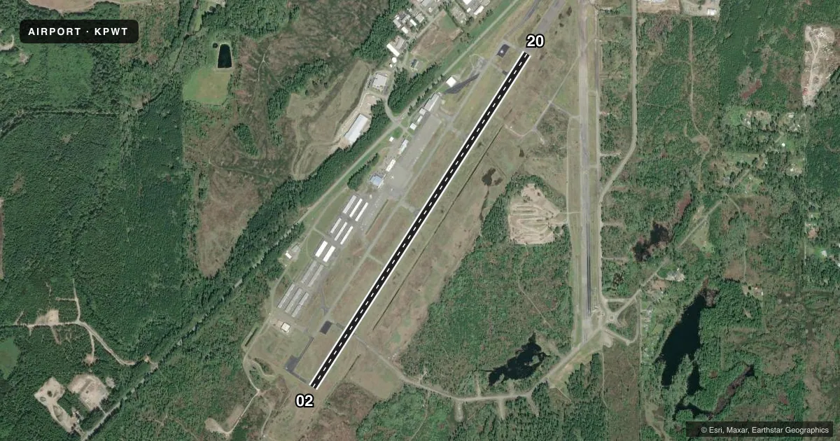
Runways & pattern
Full pagePattern entry · RWY 20
LEFT TRAFFICRunway end performance
| End | TORA | TODA | ASDA | LDA | VGSI | Approach lights | Obstruction |
|---|---|---|---|---|---|---|---|
| 02 | — | — | — | — | PAPI 4-box left(3°) | — | — |
| 20 | — | — | — | — | PAPI 4-box left(2.83°) | MALSR | 33', fence, 1740' from thr, 300' R of cntrln, slope 46 |
Declared distances in feet. TORA = takeoff run available, TODA = takeoff distance, ASDA = accelerate-stop, LDA = landing distance.
Airport sketch
Runways drawn to scale from FAA survey coordinates, rendered over satellite imagery. Not for navigation.
Approaches & charts
ILS · 1
Services on the field
Fuel grades, oxygen, maintenance, ramp storage and lighting — as declared to the FAA by the airport operator.
Fuel & services
- Fuel
- 100LLA
- Oxygen (bottled)
- Not available
- Oxygen (bulk)
- Not available
- Airframe repair
- Major
- Power plant repair
- Major
- Other services
- AFRT,AMB,AVNCS,CHTR,INSTR,RNTL
Ramp & ground
- Transient storage
- Tie-down
- Landing fee
- No fee published
- Customs
- Not available
- Lighting schedule
- SEE RMK
- Beacon schedule
- SS-SR
- Beacon
- White / Green (civil land)(WG)
- Wind indicator
- Lighted
- Segmented circle
- Yes
Fuel & FBOs
Cheapest 100LL and Jet A on the field and nearby. Always confirm with the FBO before taxi.
Airport notes
Surface conditions, obstructions, local procedures, lighting outages and other notes published with each FAA cycle.
General notes
- FENCE CROSSES N END OF ABND RWY.
- FOR CD CTC SEATTLE APCH AT 206-214-4723.
- WINTER WEATHER OPS AND REPORTING MON - FRI 8:00-16:30.
Lighting notes
- ACTVT MALSR RWY 20; REIL RWY 02; PAPI RWY 02; HIRL 02/20; TWY LGTS - CTAF. PAPI RWY 20 OPR CONSLY.
Fuel notes
- 100LL24 HR FUEL TRML 300 FT WSW OF TWY A4, ONLY FOR 100LL.
Approach & departure obstructions
- 02+6 FT TRN 25 FT FM RWY END & 250 FT R.
- 20+6 FT' FENCE 0 TO 200 FT FM RWY END 300 FT R.
Other notes
- THIS AIRPORT HAS BEEN SURVEYED BY THE NATIONAL GEODETIC SURVEY.
- ESTABD PRIOR TO 1959.
- PILOT MUST PRVD TIEDOWNS.
VFR map & nearby airports
VFR sectional. Tap any ICAO chip to open that airport.
Key facts · KPWT
Answer card- ICAO
- KPWT
- Name
- BREMERTON NTL
- Location
- BREMERTON, WASHINGTON
- Elevation
- 444 ft MSL
- Traffic pattern altitude
- 1,444 ft MSL (1,000 AGL)
- Control tower
- Non-towered (use CTAF)
- Total runways
- 1
- Longest runway
- 02/20 · 6,000 ft
- Published ILS approaches
- 1
- Published frequencies
- 7
- Magnetic variation
- 16°
- Current flight rules
- VFR
- Current wind
- 210° at 8 kt
- Favored runway now
- RWY 20
Bremerton Ntl sits in Bremerton, Washington at 444 ft MSL. It has one runway. Runway 02/20 is 6,000 ft asphalt, so it gives you a solid length for most general aviation work. The field is non-towered. Use CTAF 123.05 for local traffic. Seattle Approach handles IFR services. Clearance delivery is with Seattle Approach at 206-214-4723.
The airport has one ILS approach to runway 20. Lighting is good to know before you go. MALSR is used for runway 20. REIL and PAPI are available for runway 02. PAPI for runway 20 runs continuously. High intensity runway lights are available on both ends. Taxiway lights are controlled by CTAF.
Pattern altitude is not published. Use the standard 1,000 ft AGL for light piston aircraft unless you get current local guidance. That puts the pattern at about 1,444 ft MSL. Avian Flight Center is on the field. It carries 100LL, Jet A and Jet A Prist. The 24-hour fuel terminal is 300 feet west-southwest of taxiway A4. It is only for 100LL. Be aware of the published obstructions. There is a 6-foot tree near the runway 02 end. There is also a 6-foot fence near the runway 20 end. Pilots must provide tiedowns.