METAR & TAF 83Q
83Q does not publish a METAR.
Showing the nearest reporting station: KPWT (BREMERTON NTL) · 14.7 NM away. Conditions at 83Q may differ.
METAR · KPWT
Observed 05:56Z
KPWT 270556Z AUTO 20007KT 10SM SCT110 14/13 A3007 RMK AO2 SLP186 60000 T01390128 10189 20139 52002
- Wind
- 200° @ 7 kt
- Visibility
- 10 SM
- Temp / Dew
- 14°C / 13°C
- Altimeter
- 30.07 inHg
- Clouds
- SCT
- Density alt
- -306 ft
- Ceiling
- Unlimited
- Rules
- VFR
Airport info & contacts
Manager on record, flight service, ARTCC, attendance schedule and pattern altitude — published by the FAA and refreshed every 28 days.
Location
- From city
- 0 NM N
- VFR sectional
- SEATTLE
- ARTCC
- ZSE · SEATTLE
- NOTAM facility
- SEA (NOTAM-D)
Airport manager
- Name
- CAROL TRIPP
- Phone
- 360-779-9905
- Address
- 18809 FRONT ST. NW #1, POULSBO WA 98370
Flight service · Hours
- FSS SEA
- SEATTLE1-800-WX-BRIEF
- Attendance
- 0800-1600
Frequencies
Tap any row to copy the frequency to your clipboard.
Runways & pattern
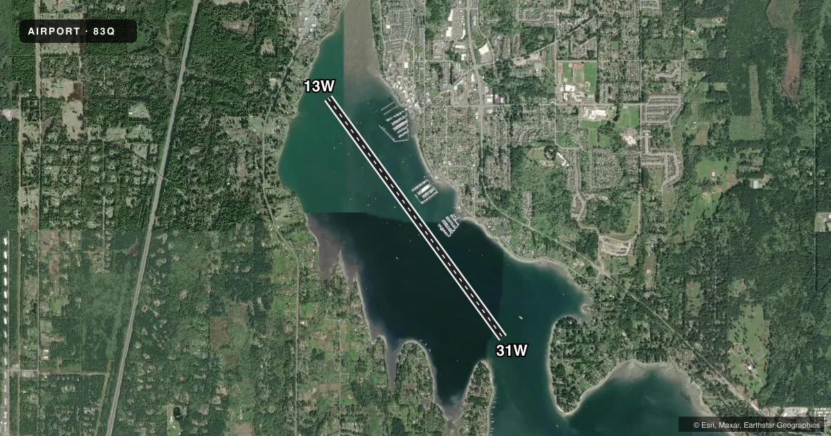
Full pagePattern entry · RWY 13W
RIGHT TRAFFICAirport sketch
Runways drawn to scale from FAA survey coordinates, rendered over satellite imagery. Not for navigation.
Approaches & charts
Services on the field
Fuel grades, oxygen, maintenance, ramp storage and lighting — as declared to the FAA by the airport operator.
Fuel & services
- Fuel
- Not available
Ramp & ground
- Transient storage
- Not published
- Segmented circle
- No
Fuel & FBOs
Cheapest 100LL and Jet A on the field and nearby. Always confirm with the FBO before taxi.
Airport notes
Surface conditions, obstructions, local procedures, lighting outages and other notes published with each FAA cycle.
General notes
- ORANGE BUOY 100 FT SW OF TSNT DOCK MARKS LOW TIDE ROCKS.
- DOCK NOT ACCESSIBLE DURING -2 FT OR GREATER LOW TIDES.
- DOCK CLSD 3RD WKEND IN MAY.
- FOR CD CTC SEATTLE APCH AT 206-214-4722.
Other notes
- TSNT DOCK AVBL.
- 1NO ATTENDANCE THANKSGIVING AND CHRISTMAS.
- MANAGERCAROL.TRIPP@PORTOFPOULSBO.COM
- OWNERTIDELANDS ARE OWNED BY STATE OF WA AND LEASED TO PORT.
- OWNEREXTENSION 5
VFR map & nearby airports
VFR sectional. Tap any ICAO chip to open that airport.
Key facts · 83Q
Answer card- ICAO
- 83Q
- Name
- PORT OF POULSBO MARINA MOORAGE
- Location
- POULSBO, WASHINGTON
- Elevation
- 0 ft MSL
- Traffic pattern altitude
- 1,000 ft MSL (1,000 AGL)
- Control tower
- Non-towered (use CTAF)
- Total runways
- 1
- Longest runway
- 13W/31W · 9,037 ft
- Published ILS approaches
- 0
- Published frequencies
- 1
- Magnetic variation
- 20°
- Current flight rules
- VFR
- Current wind
- 200° at 7 kt
- Favored runway now
- RWY 13W
Port of Poulsbo Marina Moorage sits in Poulsbo, Washington at field elevation 0 ft MSL. This is a water airport with one runway, 13W/31W, which is 9,037 ft long. The runway headings are magnetic 146° and 326°. There is no control tower. CTAF is 122.9. No ILS approaches are published here.
Pattern altitude is not published. Use standard 1,000 ft AGL for light piston planning unless the current Chart Supplement says otherwise. For this field, that works out to 1,000 ft MSL. Pilots should also note the published remarks. Clearance delivery goes through Seattle Approach at 206-214-4722. The transient dock is available. It is closed the third weekend in May. The dock is also not accessible during minus 2 feet or greater low tides. An orange buoy 100 feet southwest of the transient dock marks low tide rocks.
There are no on-field FBOs listed. Contact the airport operator directly or the FBO directly by phone for current services before arrival. For a first visit, plan for water operations, tide limits and dock access before you launch. Check the current FAA Chart Supplement for any additional local restrictions or operational notes.