METAR & TAF S60
S60 does not publish a METAR.
Showing the nearest reporting station: KPAE (SEATTLE PAINE FLD INTL) · 9.0 NM away. Conditions at S60 may differ.
METAR · KPAE
Observed 14:53Z
KPAE 271453Z 18010KT 10SM BKN070 OVC095 16/12 A3008 RMK AO2 SLP186 T01610122 53006
- Wind
- 180° @ 10 kt
- Visibility
- 10 SM
- Temp / Dew
- 16°C / 12°C
- Altimeter
- 30.08 inHg
- Clouds
- OVC
- Density alt
- -55 ft
- Ceiling
- 7,000 ft AGL
- Rules
- VFR
Airport info & contacts
Manager on record, flight service, ARTCC, attendance schedule and pattern altitude — published by the FAA and refreshed every 28 days.
Location
- From city
- 1 NM S
- VFR sectional
- SEATTLE
- ARTCC
- ZSE · SEATTLE
- NOTAM facility
- SEA (NOTAM-D)
Airport manager
- Name
- SARAH FELLER
- Phone
- 425-486-1257
- Address
- PO BOX 82064, KENMORE WA 98028-0064
Flight service · Hours
- FSS SEA
- SEATTLE1-800-WX-BRIEF
- Attendance
- DAWN-DUSK
Frequencies
Tap any row to copy the frequency to your clipboard.
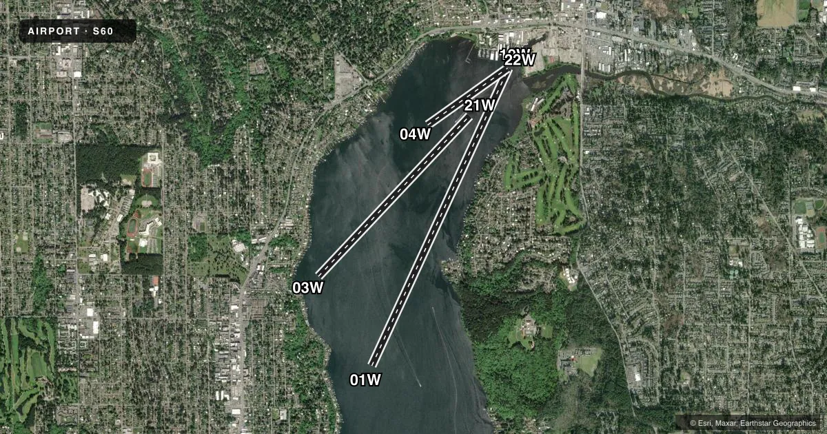
Runways & pattern
Full pagePattern entry · RWY 19W
LEFT TRAFFICAirport sketch
Runways drawn to scale from FAA survey coordinates, rendered over satellite imagery. Not for navigation.
Approaches & charts
Services on the field
Fuel grades, oxygen, maintenance, ramp storage and lighting — as declared to the FAA by the airport operator.
Fuel & services
- Fuel
- 100LLA
- Oxygen (bottled)
- Not available
- Oxygen (bulk)
- Not available
- Airframe repair
- Major
- Power plant repair
- Major
- Other services
- BCHGR,CHTR,INSTR,SALES
Ramp & ground
- Transient storage
- Tie-down
- Landing fee
- No fee published
- Customs
- Not available
- Wind indicator
- Yes
- Segmented circle
- No
Fuel & FBOs
Cheapest 100LL and Jet A on the field and nearby. Always confirm with the FBO before taxi.
Airport notes
Surface conditions, obstructions, local procedures, lighting outages and other notes published with each FAA cycle.
General notes
- APCH SFC DATA NOT CKD.
- LOADING EQUP & 100 FT CRANES PARKED ADJ TO FBO AREA CERTAIN PDS OF THE YEAR.
- 8 BUOYS MKD 7 KTS SPD LIMIT AREA WI LDG ZONE - UNLGTD; SEAPLANES EXEMPT FM 7 KTS SPD LMT.
- UNLGTD CRANE 75 FT AGL & PILINGS 6 FT ABOVE WATER RWY 21 & 22.
- 2 +6 FT NAVL BUOYS MKGD S SIDE OF COML WATERLANE; LGTD WITH BLINKING DIM RED LGTS; BLINK AT APRX 2 SEC INTVL; EXTRMLY DFCLT TO SEE.
- SFC WATERCRAFT ENTERING OPRG AREA FM CHANNEL E OF RWY 01/19.
- FOR CD CTC SEATTLE APCH AT 206-214-4722.
- KENMORE AIR DOCK FREQ 130.30.
- FOR TSNT PRKG & DOCK ACES CALL AT LEAST 3 HRS PRIOR TO ARR, CTC KENMORE AIR DISPATCH FOR APVL AT 425-486-1257, EXT. 2010.
- ARPT HAS SKED SVC.
Other notes
- ESTABD PRIOR TO 15 MAY 1959.
- OWNEROWNERS: GREEN HORNET ENTERPRISES LLC AND MUNRO BANKS HOLDCO INC.
- MANAGEREXT. 2240
VFR map & nearby airports
VFR sectional. Tap any ICAO chip to open that airport.
Key facts · S60
Answer card- ICAO
- S60
- Name
- KENMORE AIR HARBOR
- Location
- KENMORE, WASHINGTON
- Elevation
- 18.7 ft MSL
- Traffic pattern altitude
- 1,018.7 ft MSL (1,000 AGL)
- Control tower
- Non-towered (use CTAF)
- Total runways
- 3
- Longest runway
- 01W/19W · 10,000 ft
- Published ILS approaches
- 0
- Published frequencies
- 2
- Magnetic variation
- 15°
- Current flight rules
- VFR
- Current wind
- 180° at 10 kt
- Favored runway now
- RWY 19W
Kenmore Air Harbor sits in Kenmore, Washington on the north end of Lake Washington. Field elevation is 18.7 ft MSL. This is a seaplane base with 3 water runways. The longest is 01W/19W at 10,000 ft. There is no control tower. CTAF and UNICOM are both 122.7. No ILS approaches are published.
Pattern altitude is not published. Use the standard 1,000 ft AGL for light piston operations unless the current FAA Chart Supplement or local procedures say otherwise. The field carries a lot of water traffic. Published remarks call out buoys in the landing zone. They also note a commercial waterlane to the south and surface craft entering from the channel east of 01W/19W. There is also an unlighted crane 75 ft AGL and pilings near 21W and 22W, so a close look at the landing area matters.
Kenmore Air Harbor is the on-field FBO. It carries 100LL and Jet A. Transient parking and dock access require a call at least 3 hours before arrival for approval. The airport also has scheduled service. For a first-time arrival, plan for seaplane traffic, dock coordination and good visual scanning around the waterlane and nearby obstructions.