METAR & TAF W16
W16 does not publish a METAR.
Showing the nearest reporting station: KPAE (SEATTLE PAINE FLD INTL) · 11.7 NM away. Conditions at W16 may differ.
METAR · KPAE
Observed 05:53Z
KPAE 270553Z AUTO 16007KT 10SM SCT090 BKN120 16/12 A3007 RMK AO2 RAB0454E19 SLP181 P0000 60000 T01610122 10189 20161 50001
- Wind
- 160° @ 7 kt
- Visibility
- 10 SM
- Temp / Dew
- 16°C / 12°C
- Altimeter
- 30.07 inHg
- Clouds
- BKN
- Density alt
- -4 ft
- Ceiling
- 12,000 ft AGL
- Rules
- VFR
Airport info & contacts
Manager on record, flight service, ARTCC, attendance schedule and pattern altitude — published by the FAA and refreshed every 28 days.
Location
- From city
- 2 NM NW
- VFR sectional
- SEATTLE
- ARTCC
- ZSE · SEATTLE
- NOTAM facility
- SEA (NOTAM-D)
Airport manager
- Name
- ROGER HABICH
- Phone
- 425-239-8791
- Address
- 3616 COLBY AVE #144, EVERETT WA 98201
Flight service · Hours
- FSS SEA
- SEATTLE1-800-WX-BRIEF
- Attendance
- OCT-MAR · 0900-DARK
- APR-SEP · 0900-1900
Frequencies
Tap any row to copy the frequency to your clipboard.
Runways & pattern
Full pagePattern entry · RWY 07
RIGHT TRAFFICRunway end performance
| End | TORA | TODA | ASDA | LDA | VGSI | Approach lights | Obstruction |
|---|---|---|---|---|---|---|---|
| 07 | — | — | — | — | — | — | 50', pline, 1913' from thr, 0' R of cntrln, slope 34 |
| 25 | — | — | — | — | — | — | 88', trees, 1164' from thr, 0' R of cntrln, slope 10 |
Declared distances in feet. TORA = takeoff run available, TODA = takeoff distance, ASDA = accelerate-stop, LDA = landing distance.
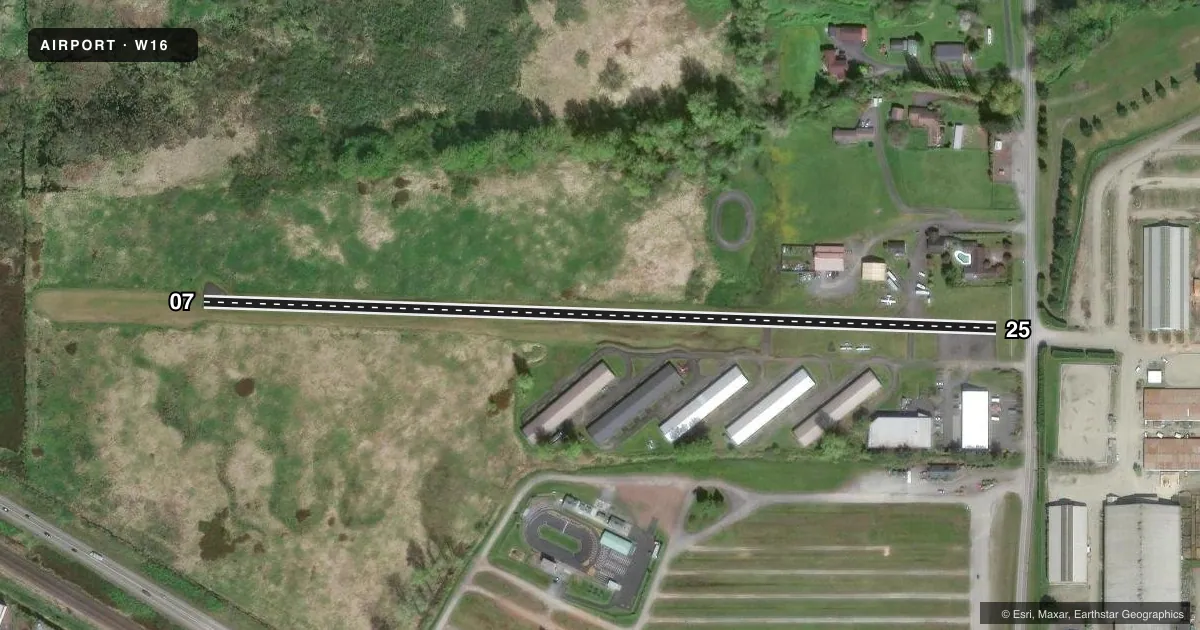
Airport sketch
Runways drawn to scale from FAA survey coordinates, rendered over satellite imagery. Not for navigation.
Approaches & charts
Services on the field
Fuel grades, oxygen, maintenance, ramp storage and lighting — as declared to the FAA by the airport operator.
Fuel & services
- Fuel
- Not available
- Oxygen (bottled)
- Not available
- Oxygen (bulk)
- Not available
- Airframe repair
- Major
- Power plant repair
- Major
Ramp & ground
- Transient storage
- Tie-down
- Landing fee
- No fee published
- Customs
- Not available
- Lighting schedule
- SS-SR
- Wind indicator
- Yes
- Segmented circle
- No
Fuel & FBOs
Cheapest 100LL and Jet A on the field and nearby. Always confirm with the FBO before taxi.
Airport notes
Surface conditions, obstructions, local procedures, lighting outages and other notes published with each FAA cycle.
General notes
- RWY ELEV: 25 END 46', 7 END 33'.
- SOLAR POWERED RUNWAY LIGHTS.
- FOR CD CTC SEATTLE APCH AT 206-214-4722.
Approach & departure obstructions
- 07GRASS & WEEDS AT 70'; +4' POSTS AT 100'.
- 256 FT FENCE 50 FT FM END OF RWY & ROAD 90 FT FM END OF RWY; 10 FT FENCE AND 20 FT HEDGE 135 FT FROM END OF RWY.
- 07MARKINGS ARE FADED.
- 25MARKINGS ARE FADED.
- 07NUMBERS 200' E OF DSPLCD THR; NUMBERS ONLY; NO CNTRLN. WORD - MONROE - PAINTED MIDFIELD ON RY.
- 25RWY 25 APCH RATIO 28:1 FROM DSPCLD THR
- 25ACFT PARKED IN PRIMARY SFC.
Other notes
- NO OBJECION PROVIDED RWY 25 IS DSPLCD 500'.
- PILOTS BRING OWN ROPES.
- 07/25UNSEALED CRACKS AND JOINTS. ALLIGATOR CRACKING AND VEGETATION THROUGH CRACKS AND JOINTS.
VFR map & nearby airports
VFR sectional. Tap any ICAO chip to open that airport.
Key facts · W16
Answer card- ICAO
- W16
- Name
- FIRST AIR FLD
- Location
- MONROE, WASHINGTON
- Elevation
- 50 ft MSL
- Traffic pattern altitude
- 1,050 ft MSL (1,000 AGL)
- Control tower
- Non-towered (use CTAF)
- Total runways
- 1
- Longest runway
- 07/25 · 2,087 ft
- Published ILS approaches
- 0
- Published frequencies
- 1
- Magnetic variation
- 20°
- Current flight rules
- VFR
- Current wind
- 160° at 7 kt
- Favored runway now
- RWY 07
First Air Fld is in Monroe, Washington. Field elevation is 50 ft MSL. It has one runway, 07/25, which is 2,087 ft long. The airport is not towered. CTAF is 122.9. No ILS approaches are published here.
Pattern altitude is not published. Use 1,000 ft AGL for light piston operations unless the current Chart Supplement says otherwise. That puts the pattern at 1,050 ft MSL based on the field elevation in the facts. The runway is asphalt. The published remarks show unsealed cracks, joints and some vegetation through the surface. Markings are faded. Runway 25 is displaced 500 feet. The numbers for runway 07 are 200 feet east of the displaced threshold. Aircraft are parked in the primary surface, so taxi and parking awareness matters.
There are no on-field FBOs listed in the facts. Contact the airport operator directly before arrival, or call the field on CTAF for current FBO availability. Published remarks also note obstructions near both ends. Runway 07 has grass, weeds and posts near the approach. Runway 25 has fences and a road close to the departure end. Pilots should plan a careful look at the runway condition and the displaced threshold before committing. For clearance delivery, contact Seattle Approach at 206-214-4722.