METAR & TAF W10
W10 does not publish a METAR.
Showing the nearest reporting station: KPAE (SEATTLE PAINE FLD INTL) · 9.3 NM away. Conditions at W10 may differ.
METAR · KPAE
Observed 14:53Z
KPAE 271453Z 18010KT 10SM BKN070 OVC095 16/12 A3008 RMK AO2 SLP186 T01610122 53006
- Wind
- 180° @ 10 kt
- Visibility
- 10 SM
- Temp / Dew
- 16°C / 12°C
- Altimeter
- 30.08 inHg
- Clouds
- OVC
- Density alt
- 258 ft
- Ceiling
- 7,000 ft AGL
- Rules
- VFR
Airport info & contacts
Manager on record, flight service, ARTCC, attendance schedule and pattern altitude — published by the FAA and refreshed every 28 days.
Location
- From city
- 2 NM SW
- VFR sectional
- SEATTLE
- ARTCC
- ZSE · SEATTLE
- NOTAM facility
- SEA (NOTAM-D)
Airport manager
- Name
- SKY & TARA RUDOLPH
- Phone
- (360) 321-0510
- Address
- PO BOX 852, LANGLEY WA 98260
Flight service · Hours
- FSS SEA
- SEATTLE1-800-WX-BRIEF
- Attendance
- Unattended
Frequencies
Tap any row to copy the frequency to your clipboard.
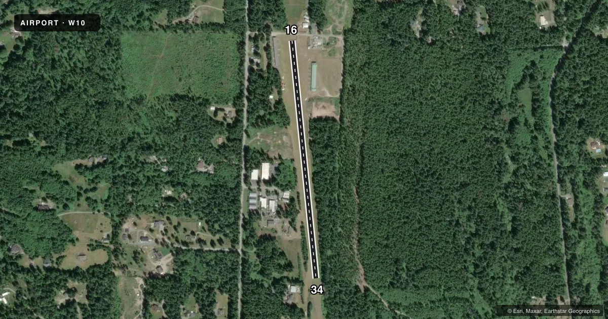
Runways & pattern
Full pagePattern entry · RWY 16
LEFT TRAFFICRunway end performance
| End | TORA | TODA | ASDA | LDA | VGSI | Approach lights | Obstruction |
|---|---|---|---|---|---|---|---|
| 16 | — | — | — | — | — | — | 125', trees, 756' from thr, 0' R of cntrln, slope 4 |
| 34 | — | — | — | — | — | — | 53', tree, 716' from thr, 28' R of cntrln, slope 9 |
Declared distances in feet. TORA = takeoff run available, TODA = takeoff distance, ASDA = accelerate-stop, LDA = landing distance.
Airport sketch
Runways drawn to scale from FAA survey coordinates, rendered over satellite imagery. Not for navigation.
Approaches & charts
Services on the field
Fuel grades, oxygen, maintenance, ramp storage and lighting — as declared to the FAA by the airport operator.
Fuel & services
- Fuel
- Not available
- Oxygen (bottled)
- Not available
- Oxygen (bulk)
- Not available
Ramp & ground
- Transient storage
- Tie-down
- Landing fee
- No fee published
- Customs
- Not available
- Wind indicator
- Yes
- Segmented circle
- No
Fuel & FBOs
Cheapest 100LL and Jet A on the field and nearby. Always confirm with the FBO before taxi.
Airport notes
Surface conditions, obstructions, local procedures, lighting outages and other notes published with each FAA cycle.
General notes
- FOR CD CTC SEATTLE APCH AT 206-214-4722.
- WILDLIFE INVOF RWY.
- TREES WI PRI SFC.
Approach & departure obstructions
- 16+3 FT FENCE AT 74 FT, ROAD AT 100 FT, 6 FT BRUSH AT 118 FT FM THR, 10 FT HIGH GND 200 FT FM THR, TREES 48-125 FT R, 150 FT FR THR.
- 34+6 FT -20 FT BRUSH 0 FT - 200 FT FM THR; 71 FT RIGHT & 110 FT LEFT, 40 FT - 80 FT TREES 88 FT RIGHT AND 50 FT LEFT 0 FT - 200 FT FM THR.
Other notes
- TIE DOWNS PILOT PROVIDED
VFR map & nearby airports
VFR sectional. Tap any ICAO chip to open that airport.
Key facts · W10
Answer card- ICAO
- W10
- Name
- WHIDBEY AIR PARK
- Location
- LANGLEY, WASHINGTON
- Elevation
- 271 ft MSL
- Traffic pattern altitude
- 1,271 ft MSL (1,000 AGL)
- Control tower
- Non-towered (use CTAF)
- Total runways
- 1
- Longest runway
- 16/34 · 2,470 ft
- Published ILS approaches
- 0
- Published frequencies
- 1
- Magnetic variation
- 21°
- Current flight rules
- VFR
- Current wind
- 180° at 10 kt
- Favored runway now
- RWY 16
Whidbey Air Park is in Langley, Washington on Whidbey Island. Field elevation is 271 ft MSL. The airport has one runway, 16/34, which is 2,470 ft long and asphalt. There is no control tower. CTAF is 122.9. No ILS approaches are published here. Pattern altitude is not published, so use the current Chart Supplement for the published pattern altitude before flight.
This is a small field with some real operating limits. Published remarks note trees within the primary surface. There are also obstructions near both runway ends. Runway 34 has brush and trees close in. Runway 16 has a fence, a road, brush, rising ground and trees near the threshold area. Wildlife is also noted in the runway vicinity. Tie downs are pilot provided, so plan accordingly if you are staying on the ground.
No on-field FBOs are listed in the facts. Contact the airport operator directly before arrival, or call the field on CTAF or UNICOM for current FBO availability. For clearance delivery, Seattle Approach is listed at 206-214-4722. If you are planning a first visit, pay close attention to the runway environment and the published obstructions. This is not a place to assume extra margin on short final. Check the current Chart Supplement for any noise or curfew restrictions before flying into the field.