METAR & TAF 74S
74S does not publish a METAR.
Showing the nearest reporting station: KBVS (SKAGIT RGNL) · 9.7 NM away. Conditions at 74S may differ.
METAR · KBVS
Observed 08:35Z
KBVS 270835Z AUTO 00000KT 10SM OVC110 14/14 A3006 RMK A01
- Wind
- 000° @ 0 kt
- Visibility
- 10 SM
- Temp / Dew
- 14°C / 14°C
- Altimeter
- 30.06 inHg
- Clouds
- OVC
- Density alt
- 12 ft
- Ceiling
- 11,000 ft AGL
- Rules
- VFR
Airport info & contacts
Manager on record, flight service, ARTCC, attendance schedule and pattern altitude — published by the FAA and refreshed every 28 days.
Location
- From city
- 2 NM W
- VFR sectional
- SEATTLE
- ARTCC
- ZSE · SEATTLE
- NOTAM facility
- SEA (NOTAM-D)
Airport manager
- Name
- JOHN DUMAS
- Phone
- 360-293-3134
- Address
- 317 COMMERCIAL AVENUE, ANACORTES WA 98221
Flight service · Hours
- FSS SEA
- SEATTLE1-800-WX-BRIEF
- Attendance
- Unattended
Frequencies
Tap any row to copy the frequency to your clipboard.
Runways & pattern
Full pagePattern entry · RWY 18
RIGHT TRAFFICRunway end performance
| End | TORA | TODA | ASDA | LDA | VGSI | Approach lights | Obstruction |
|---|---|---|---|---|---|---|---|
| 18 | — | — | — | — | PAPI 4-box right(3°) | — | 22', tree, 767' from thr, 0' R of cntrln, slope 25 |
| 36 | — | — | — | — | PAPI 4-box left(3°) | — | 20', trees, 1158' from thr, 0' R of cntrln, slope 46 |
Declared distances in feet. TORA = takeoff run available, TODA = takeoff distance, ASDA = accelerate-stop, LDA = landing distance.
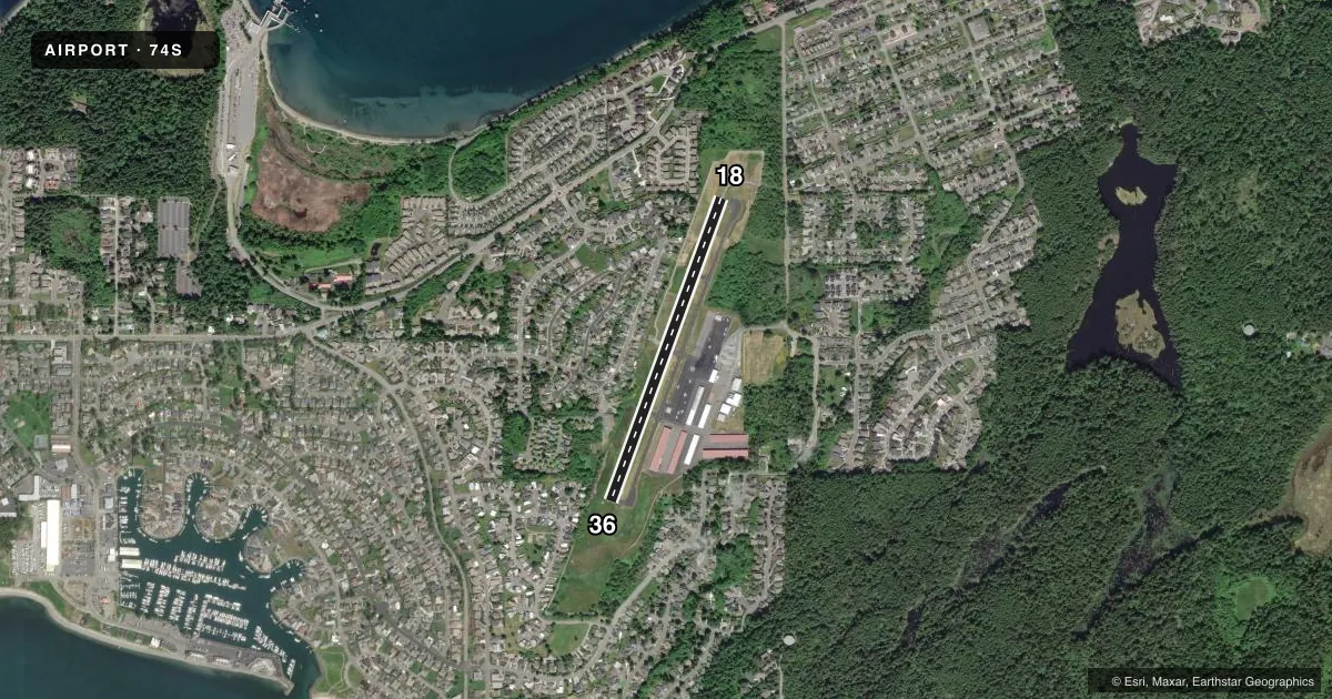
Airport sketch
Runways drawn to scale from FAA survey coordinates, rendered over satellite imagery. Not for navigation.
Approaches & charts
Services on the field
Fuel grades, oxygen, maintenance, ramp storage and lighting — as declared to the FAA by the airport operator.
Fuel & services
- Fuel
- 100A
- Oxygen (bottled)
- Not available
- Oxygen (bulk)
- Not available
- Airframe repair
- Not available
- Power plant repair
- Not available
- Other services
- AFRT,AMB,CHTR
Ramp & ground
- Transient storage
- Tie-down
- Landing fee
- No fee published
- Customs
- Not available
- Lighting schedule
- SEE RMK
- Beacon schedule
- SS-SR
- Beacon
- White / Green (civil land)(WG)
- Wind indicator
- Lighted
- Segmented circle
- Yes
Fuel & FBOs
Cheapest 100LL and Jet A on the field and nearby. Always confirm with the FBO before taxi.
Airport notes
Surface conditions, obstructions, local procedures, lighting outages and other notes published with each FAA cycle.
General notes
- MILITARY ARRIVAL CORRIDOR N & W OF ARPT.
- RWY 36 PREFERRED CALM WIND RY.
- NOISE ABATEMENT PROCEDURES IN EFFECT; CTC AMGR 360-293-3134.
- NO TOUCH & GO LDGS.
- FOR CD CTC WHIDBEY APCH AT 360-257-3310.
- DEER AND COYOTE NEAR MOV AREAS.
Lighting notes
- ACTVT MIRL & REILS RY 18/36 - CTAF.
Other notes
- AUTOMATED UNICOM; 122.9. ADZY ALSO AVBL AT 617-262-3825.
- PILOTS BRING OWN TIEDOWNS.
VFR map & nearby airports
VFR sectional. Tap any ICAO chip to open that airport.
Key facts · 74S
Answer card- ICAO
- 74S
- Name
- ANACORTES
- Location
- ANACORTES, WASHINGTON
- Elevation
- 246.1 ft MSL
- Traffic pattern altitude
- 1,246.1 ft MSL (1,000 AGL)
- Control tower
- Non-towered (use CTAF)
- Total runways
- 1
- Longest runway
- 18/36 · 3,018 ft
- Published ILS approaches
- 0
- Published frequencies
- 1
- Magnetic variation
- 21°
- Current flight rules
- VFR
- Current wind
- 000° at 0 kt
- Favored runway now
- –
Anacortes Airport is in Anacortes, Washington. The field elevation is 246.1 ft MSL. It has one runway, 18/36, which is 3,018 ft long and asphalt. There is no control tower. CTAF is 128.25.
No ILS approaches are published here. Pattern altitude is not published, so use the standard 1,000 ft AGL for light piston operations unless the current FAA Chart Supplement says otherwise. For this field, that works out to about 1,246 ft MSL based on the listed elevation.
Anacortes Airport has one on-field FBO, Anacortes Airport. It carries 100LL. Call (360) 293-3134 before arrival if you need current service details. Published remarks say noise abatement procedures are in effect. They also note a military arrival corridor north and west of the airport. No touch-and-go landings are permitted. Runway 36 is the preferred calm wind runway. Medium intensity runway lights and runway end identifier lights on 18/36 are activated by CTAF. Deer and coyote are near the movement areas, so keep a sharp scan on taxi and rollout. Pilots must bring their own tiedowns.