METAR & TAF KBVS
Current METAR
Observed 15:35Z
KBVS 271535Z AUTO 18005G14KT 10SM BKN100 17/16 A3006 RMK A01
- Wind
- 180° @ 5G14 kt
- Visibility
- 10 SM
- Temp / Dew
- 17°C / 16°C
- Altimeter
- 30.06 inHg
- Clouds
- BKN
- Density alt
- 246 ft
- Ceiling
- 10,000 ft AGL
- Rules
- VFR
Airport info & contacts
Manager on record, flight service, ARTCC, attendance schedule and pattern altitude — published by the FAA and refreshed every 28 days.
Location
- From city
- 3 NM W
- VFR sectional
- SEATTLE
- Pattern altitude
- 500 ft AGL · 645 ft MSL
- ARTCC
- ZSE · SEATTLE
- NOTAM facility
- BVS (NOTAM-D)
Airport manager
- Name
- KEITH D. LOVE
- Phone
- 360-757-0011
- Address
- 15400 AIRPORT DR, 15400 AIRPORT DR, BURLINGTON WA 98233
Flight service · Hours
- FSS SEA
- SEATTLE1-800-WX-BRIEF
- Attendance
- 0700-1900
Frequencies
Tap any row to copy the frequency to your clipboard.
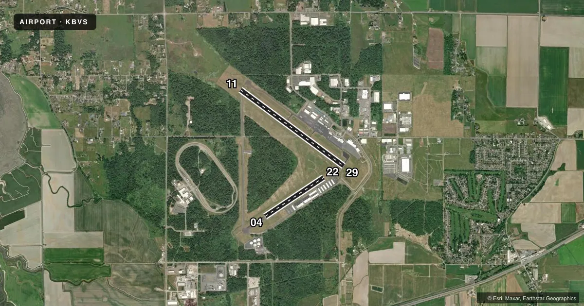
Runways & pattern
Full pagePattern entry · RWY 11
LEFT TRAFFIC| Runway | Heading (°M) | Length | Surface | Traffic |
|---|---|---|---|---|
| 11/29Favored | 110° / 290° | 5,480 ft | ASPH | Standard L |
| 04/22 | 40° / 220° | 3,000 ft | ASPH | Standard L |
Runway end performance
| End | TORA | TODA | ASDA | LDA | VGSI | Approach lights | Obstruction |
|---|---|---|---|---|---|---|---|
| 11 | — | — | — | — | PAPI 4-box left(3°) | — | — |
| 29 | — | — | — | — | PAPI 4-box left(3°) | — | — |
| 04 | — | — | — | — | PAPI 2-box left(4°) | — | — |
| 22 | — | — | — | — | PAPI 2-box left(3°) | — | — |
Declared distances in feet. TORA = takeoff run available, TODA = takeoff distance, ASDA = accelerate-stop, LDA = landing distance.
Airport sketch
Runways drawn to scale from FAA survey coordinates, rendered over satellite imagery. Not for navigation.
Approaches & charts
Services on the field
Fuel grades, oxygen, maintenance, ramp storage and lighting — as declared to the FAA by the airport operator.
Fuel & services
- Fuel
- 100LLA
- Oxygen (bottled)
- HIGH/LOW
- Oxygen (bulk)
- Not available
- Airframe repair
- Major
- Power plant repair
- Major
- Other services
- AFRT,AVNCS,CHTR,INSTR,RNTL,SALES
Ramp & ground
- Transient storage
- Tie-down
- Landing fee
- No fee published
- Customs
- Not available
- Lighting schedule
- SEE RMK
- Beacon schedule
- SS-SR
- Beacon
- White / Green (civil land)(WG)
- Wind indicator
- Lighted
- Segmented circle
- Yes
Fuel & FBOs
Cheapest 100LL and Jet A on the field and nearby. Always confirm with the FBO before taxi.
Airport notes
Surface conditions, obstructions, local procedures, lighting outages and other notes published with each FAA cycle.
General notes
- MIGRATORY WATERFOWL & BIRDS ON AND INVOF ARPT.
- HELICOPTER TRAINING OPS ON AIRPORT W/ AUTOROTATIONS ON RUNWAY
- USE OF TWY B BY ACFT WITH WINGSPAN 49 FT OR GREATER PROHIBITED WHEN RY 04/22 IN USE.
- POSSIBLE TURBULENCE INVOF EXHAUST STACKS 3,500 FT SW OF RW 04, AVOID LOW ALT OVERFLT.
- U.S. CUST SVC AVBL FOR INTL ARR. CHK PORT OF SKAGIT WEBSITE FOR REQ FOR SVC INSRT, WWW.PORTOFSKAGIT.COM. AVBL SEVEN DAYS A WEEK, PER APVL. USAGE FEES APPLY.
- FOR CD CTC WHIDBEY APCH AT 360-257-3310.
- RWY 04/22 CLSD TO ACFT MORE THAN 12500 LB AND WINGSPAN MORE THAN 49 FT.
Lighting notes
- ACTVT MIRL RY 11/29, LIRL RY 04/22, PAPI RY 11 & 29, AND REIL RY 11 & 29 - CTAF. PAPI RYS 04 & 22 OPR CONTINUOUSLY.
Approach & departure obstructions
- 04MARKINGS FADED.
- 22MARKINGS FADED.
Other notes
- PRVDD ARPT MGR BRIEFS ALL ARPT USERS ON SPL OPNS; I.E., CONVERT ABNDD N/S TWY TO LTD USE RWY 16/34; A NOTAM BE ISSUED WHICH ALERTS THE GENERAL PUBLIC TO THIS OPN & WHICH STATES THE SPL PROCS TO BE USED WHEN OPERG TO/FROM ARPT; ARPT UNICOM BE ACTVTD AND MANNED WHENEVER THIS SPL OPN IN PROG.
- ULTRALIGHT TPA 500 FT AGL.
- 2TERMINAL BUILDING OPEN 0700-1900. AFTER HOURS, ACCESS AVAILABLE TO PILOTS. TERMINAL AND APRON ADJACENT TO TERMINAL FREE PILOT ACCESS WIFI.
- 04/22WDSPR, OPN, UNSEALED CRACKS AND JOINTS.
VFR map & nearby airports
VFR sectional. Tap any ICAO chip to open that airport.
Key facts · KBVS
Answer card- ICAO
- KBVS
- Name
- SKAGIT RGNL
- Location
- BURLINGTON/MOUNT VERNON, WASHINGTON
- Elevation
- 145.1 ft MSL
- Traffic pattern altitude
- 645.1 ft MSL (500 AGL)
- Control tower
- Non-towered (use CTAF)
- Total runways
- 2
- Longest runway
- 11/29 · 5,480 ft
- Published ILS approaches
- 0
- Published frequencies
- 4
- Magnetic variation
- 16°
- Current flight rules
- VFR
- Current wind
- 180° at 5 kt
- Favored runway now
- RWY 11
Skagit Rgnl sits in Burlington and Mount Vernon, Washington. Field elevation is 145.1 ft MSL. The airport has 2 asphalt runways. The longest is 11/29 at 5,480 ft. There is no control tower. Pattern altitude is 500 ft AGL, or 645.1 ft MSL. No ILS approaches are published here.
Corporate Air Center is on the field. It carries 100LL, Jet A and Jet A Prist. The terminal building is open from 0700 to 1900. After hours, pilots still have access. Free pilot WiFi is available in the terminal and on the apron next to it. For clearance delivery, contact Whidbey Approach. CTAF and UNICOM are both 123.075.
A few operational items matter here. U.S. customs service is available for international arrivals. Check the Port of Skagit requirements before using it. Helicopter training and autorotations happen on the airport. Runway 04/22 is closed to aircraft over 12,500 lb or with a wingspan over 49 ft. Taxiway B is not for aircraft with a wingspan of 49 ft or greater when 04/22 is in use. Expect birds in the area. There can also be turbulence near the exhaust stacks southwest of runway 04. Runway 04 markings are faded, so brief that one carefully before arrival.