METAR & TAF 0W7
0W7 does not publish a METAR.
Showing the nearest reporting station: KBLI (BELLINGHAM INTL) · 8.5 NM away. Conditions at 0W7 may differ.
METAR · KBLI
Observed 12:53Z
KBLI 271253Z AUTO 00000KT 10SM BKN075 OVC090 14/14 A3005 RMK AO2 SLP182 T01390139
- Wind
- 000° @ 0 kt
- Visibility
- 10 SM
- Temp / Dew
- 14°C / 14°C
- Altimeter
- 30.05 inHg
- Clouds
- OVC
- Density alt
- 99 ft
- Ceiling
- 7,500 ft AGL
- Rules
- VFR
Airport info & contacts
Manager on record, flight service, ARTCC, attendance schedule and pattern altitude — published by the FAA and refreshed every 28 days.
Location
- From city
- 6 NM SE
- VFR sectional
- SEATTLE
- ARTCC
- ZSE · SEATTLE
- NOTAM facility
- SEA (NOTAM-D)
Airport manager
- Name
- BRIAN SCHOENING
- Phone
- 206-909-4783
- Address
- 14915 58TH LANE NE, KENMORE WA 98028
Flight service · Hours
- FSS SEA
- SEATTLE1-800-WX-BRIEF
- Attendance
- DALGT
Frequencies
Tap any row to copy the frequency to your clipboard.
Runways & pattern
Full pagePattern entry · RWY 12W
LEFT TRAFFICAirport sketch
Runways drawn to scale from FAA survey coordinates, rendered over satellite imagery. Not for navigation.
Approaches & charts
Services on the field
Fuel grades, oxygen, maintenance, ramp storage and lighting — as declared to the FAA by the airport operator.
Fuel & services
- Fuel
- Not available
- Oxygen (bottled)
- Not available
- Oxygen (bulk)
- Not available
- Airframe repair
- Major
- Power plant repair
- Major
Ramp & ground
- Transient storage
- Not published
- Landing fee
- No fee published
- Customs
- Not available
- Wind indicator
- Yes
- Segmented circle
- No
Fuel & FBOs
Cheapest 100LL and Jet A on the field and nearby. Always confirm with the FBO before taxi.
Airport notes
Surface conditions, obstructions, local procedures, lighting outages and other notes published with each FAA cycle.
General notes
- CANOE, SAILBOAT, DRONE & HANG GLDR ACTY IN VCNTY OF ARPT.
- LAND AND TAKE OFF IN THE CENTER OF THE LAKE.
- AVOID FLYING OVER NOISE SENSITIVE AREAS DURING TO/LDG
- APCH/DEP SVC PRVDD BY VICTORIA TRML ON 132.7/290.8. (604) 586-4560.
Other notes
- CALL 206-909-4783 PRIOR TO ARR TO ARNG SVCS.
- ESTABD PRIOR TO 5/15/59.
VFR map & nearby airports
VFR sectional. Tap any ICAO chip to open that airport.
Key facts · 0W7
Answer card- ICAO
- 0W7
- Name
- FLOATHAVEN
- Location
- BELLINGHAM, WASHINGTON
- Elevation
- 307 ft MSL
- Traffic pattern altitude
- 1,307 ft MSL (1,000 AGL)
- Control tower
- Non-towered (use CTAF)
- Total runways
- 1
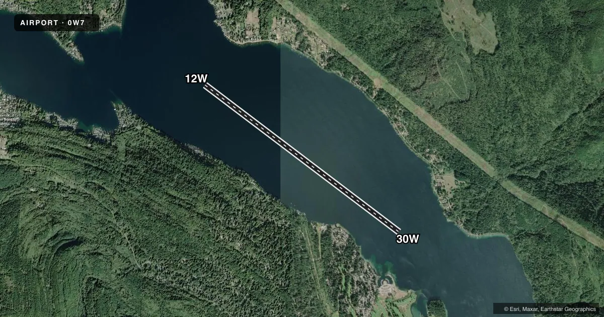
- Longest runway
- 12W/30W · 10,000 ft
- Published ILS approaches
- 0
- Published frequencies
- 1
- Magnetic variation
- 21°
- Current flight rules
- VFR
- Current wind
- 000° at 0 kt
- Favored runway now
- –
FLOATHAVEN sits in Bellingham, Washington. Field elevation is 307 ft MSL. It has one runway, 12W/30W and it is a 10,000 ft water runway. The field is not towered. CTAF is 122.9. No ILS approaches are published here.
Pattern altitude is not published. Use the standard 1,000 ft AGL for light piston operations unless the current Chart Supplement or local procedures say otherwise. The published runway headings are 127° and 307° magnetic. That matters on a water strip because wind and drift can change your setup fast. The Chart Supplement also says to land and take off in the center of the lake.
This is a water operation with other traffic in the area. Canoe, sailboat, drone and hang glider activity is reported nearby. Avoid flying over noise sensitive areas during takeoff and landing. Approach and departure service is provided by Victoria Terminal on 132.7 and 290.8. The published remarks also say to call prior to arrival to arrange services. There are no on-field FBOs listed. Verify services with the airport operator or the FBO directly by phone before you go.