METAR & TAF KORS
Current METAR
Observed 16:35Z
KORS 271635Z AUTO 18008KT 10SM FEW023 BKN070 OVC110 18/14 A3005 RMK AO2
- Wind
- 180° @ 8 kt
- Visibility
- 10 SM
- Temp / Dew
- 18°C / 14°C
- Altimeter
- 30.05 inHg
- Clouds
- OVC
- Density alt
- 242 ft
- Ceiling
- 7,000 ft AGL
- Rules
- VFR
Airport info & contacts
Manager on record, flight service, ARTCC, attendance schedule and pattern altitude — published by the FAA and refreshed every 28 days.
Location
- From city
- 1 NM N
- VFR sectional
- SEATTLE
- Pattern altitude
- 1,000 ft AGL · 1,035 ft MSL
- ARTCC
- ZVR · VANCOUVER
- NOTAM facility
- ORS (NOTAM-D)
Airport manager
- Name
- CHIP LONG
- Phone
- 360-376-5285
- Address
- PO BOX 53, EASTSOUND WA 98245
Flight service · Hours
- FSS SEA
- SEATTLE1-800-WX-BRIEF
- Attendance
- 0800-1630
Frequencies
Tap any row to copy the frequency to your clipboard.
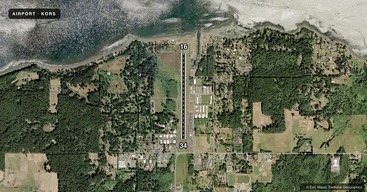
Runways & pattern
Full pagePattern entry · RWY 16
LEFT TRAFFICRunway end performance
| End | TORA | TODA | ASDA | LDA | VGSI | Approach lights | Obstruction |
|---|---|---|---|---|---|---|---|
| 16 | — | — | — | — | PAPI 4-box right(3.48°) | — | 10', road, 387' from thr, 0' R of cntrln, slope 18 |
| 34 | — | — | — | — | PAPI 2-box left(4°) | — | 128', trees, 2000' from thr, 267' R of cntrln, slope 14 |
Declared distances in feet. TORA = takeoff run available, TODA = takeoff distance, ASDA = accelerate-stop, LDA = landing distance.
Airport sketch
Runways drawn to scale from FAA survey coordinates, rendered over satellite imagery. Not for navigation.
Approaches & charts
Services on the field
Fuel grades, oxygen, maintenance, ramp storage and lighting — as declared to the FAA by the airport operator.
Fuel & services
- Fuel
- 100LL
- Other services
- AFRT,AMB,CHTR,INSTR
Ramp & ground
- Transient storage
- Tie-down
- Landing fee
- No fee published
- Customs
- Not available
- Lighting schedule
- SEE RMK
- Beacon schedule
- SS-SR
- Beacon
- White / Green (civil land)(WG)
- Wind indicator
- Lighted
- Segmented circle
- Yes
Fuel & FBOs
Cheapest 100LL and Jet A on the field and nearby. Always confirm with the FBO before taxi.
Airport notes
Surface conditions, obstructions, local procedures, lighting outages and other notes published with each FAA cycle.
General notes
- NOISE ABATEMENT PROCS IN EFCT - AMGR.
- ADNL TSNT TURF TIEDOWNS S OF SEGEMENTED CIRCLE.
- DEER ON & INVOF RWY.
- NGT CIRCLING APCH NA FM W SIDE OF RWY.
- GRASS SFC LNDG NA.
- FOR CD FOR DEP FROM RWY 16/34, CTC VICTORIA TRML AT 604-586-4561.
Lighting notes
- ACTVT REIL RWY 16 & 34; PAPI RWY 16; MIRL RWY 16/34; TWY LGTS - CTAF. REIL RWY 16 & 34 PHOTOCELL NOT AVBL DALGT.
Fuel notes
- 100LLCREDIT CARD SELF SVC H24.
Runway surface & condition
- 16/34RWY 34 CALM WIND RWY.
Approach & departure obstructions
- 163 FT SIGN 126 FT L & 19 FT FM THR; DITCH 100 FT R OF THR.
- 16FADED.
- 34FADED.
- 34PAPI UNSUBL BYD 2 DEGS LEFT AND BYD 5 DEGS RIGHT OF CNTRLN.
Other notes
- ESTABLISHED PRIOR TO 5/15/59.
VFR map & nearby airports
VFR sectional. Tap any ICAO chip to open that airport.
Key facts · KORS
Answer card- ICAO
- KORS
- Name
- ORCAS ISLAND
- Location
- EASTSOUND, WASHINGTON
- Elevation
- 34.8 ft MSL
- Traffic pattern altitude
- 1,034.8 ft MSL (1,000 AGL)
- Control tower
- Non-towered (use CTAF)
- Total runways
- 1
- Longest runway
- 16/34 · 2,901 ft
- Published ILS approaches
- 0
- Published frequencies
- 4
- Magnetic variation
- 17°
- Current flight rules
- VFR
- Current wind
- 180° at 8 kt
- Favored runway now
- RWY 16
Orcas Island Airport sits near Eastsound in Washington. Field elevation is 34.8 ft MSL. The airport has one runway. Runway 16/34 is 2,901 ft long and paved. There is no control tower. Pattern altitude is 1,000 ft AGL at 1,034.8 ft MSL.
No ILS approaches are published here. The airport uses CTAF 128.25. Whidbey approach and departure frequencies are listed for IFR work. Orcas Island Airport is on the field. It carries AVGAS 100LL. Self-serve 100LL is available by credit card 24 hours a day. The field also has medium intensity runway lights. Runway end identifier lights are installed on 16 and 34. Runway 16 has a PAPI. Runway 34 markings are faded. Runway 16 markings are faded too.
This is a small island airport, so plan for local procedures and weather that can change fast. Noise abatement procedures are in effect. Contact the airport manager before you go if you need the local run-up or arrival picture. Night circling approaches are not authorized from the west side of the runway. Runway 34 is the calm wind runway. For departure clearance from runway 16 or 34, contact Victoria Terminal. The airport also has a few close-in obstacles near runway 16. Check the current FAA Chart Supplement before you launch.