METAR & TAF S31
Current METAR
Observed 15:35Z
KS31 271535Z AUTO VRB04KT 9SM OVC010 15/14 A3004 RMK AO2 CIG 009V013 T01530139
- Wind
- VAR @ 4 kt
- Visibility
- 9 SM
- Temp / Dew
- 15°C / 14°C
- Altimeter
- 30.04 inHg
- Clouds
- OVC
- Density alt
- 110 ft
- Ceiling
- 1,000 ft AGL
- Rules
- MVFR
Airport info & contacts
Manager on record, flight service, ARTCC, attendance schedule and pattern altitude — published by the FAA and refreshed every 28 days.
Location
- From city
- 3 NM N
- VFR sectional
- SEATTLE
- ARTCC
- ZSE · SEATTLE
- NOTAM facility
- SEA (NOTAM-D)
Airport manager
- Name
- WIL CATLIN
- Phone
- 360-468-4116
- Address
- PO BOX 907, LOPEZ WA 98261
Flight service · Hours
- FSS SEA
- SEATTLE1-800-WX-BRIEF
- Attendance
- Unattended
Frequencies
Tap any row to copy the frequency to your clipboard.
Runways & pattern
Full pagePattern entry · RWY 34
LEFT TRAFFICRunway end performance
| End | TORA | TODA | ASDA | LDA | VGSI | Approach lights | Obstruction |
|---|---|---|---|---|---|---|---|
| 16 | — | — | — | — | PAPI 2-box left(4°) | — | 87', trees, 1948' from thr, 0' R of cntrln, slope 20 |
| 34 | — | — | — | — | PAPI 2-box left(4°) | — | 60', trees, 900' from thr, 0' R of cntrln, slope 11 |
Declared distances in feet. TORA = takeoff run available, TODA = takeoff distance, ASDA = accelerate-stop, LDA = landing distance.
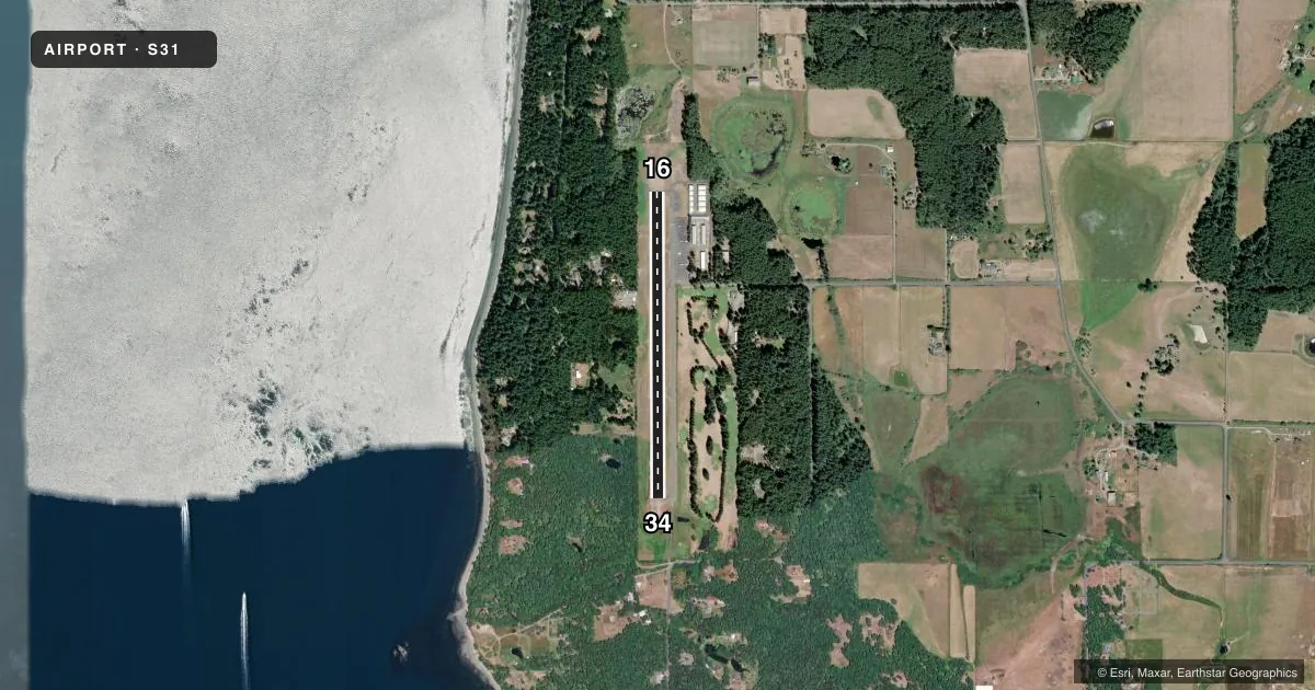
Airport sketch
Runways drawn to scale from FAA survey coordinates, rendered over satellite imagery. Not for navigation.
Approaches & charts
Services on the field
Fuel grades, oxygen, maintenance, ramp storage and lighting — as declared to the FAA by the airport operator.
Fuel & services
- Fuel
- Not available
- Oxygen (bottled)
- Not available
- Oxygen (bulk)
- Not available
- Airframe repair
- Not available
- Power plant repair
- Not available
- Other services
- AFRT,CHTR
Ramp & ground
- Transient storage
- Tie-down
- Landing fee
- Yes
- Customs
- Not available
- Beacon schedule
- SS-SR
- Beacon
- White / Green (civil land)(WG)
- Wind indicator
- Lighted
- Segmented circle
- Yes
Fuel & FBOs
Cheapest 100LL and Jet A on the field and nearby. Always confirm with the FBO before taxi.
Airport notes
Surface conditions, obstructions, local procedures, lighting outages and other notes published with each FAA cycle.
General notes
- RY 16/34 SOFT SHOULDERS & THLDS.
- FOR CD CTC WHIDBEY APCH AT 360-257-3310.
Runway surface & condition
- 16/34TWY MARKED WITH REFLECTORS.
Other notes
- ESTABD PRIOR TO 1959.
VFR map & nearby airports
VFR sectional. Tap any ICAO chip to open that airport.
Key facts · S31
Answer card- ICAO
- S31
- Name
- LOPEZ ISLAND
- Location
- LOPEZ, WASHINGTON
- Elevation
- 208.8 ft MSL
- Traffic pattern altitude
- 1,208.8 ft MSL (1,000 AGL)
- Control tower
- Non-towered (use CTAF)
- Total runways
- 1
- Longest runway
- 16/34 · 2,905 ft
- Published ILS approaches
- 0
- Published frequencies
- 1
- Magnetic variation
- 21°
- Current flight rules
- MVFR
- Current wind
- 000° at 4 kt
- Favored runway now
- RWY 34
Lopez Island Airport sits on Lopez Island in Washington. Field elevation is 208.8 ft MSL. The airport has one runway. Runway 16/34 is 2,905 ft long with asphalt pavement. There is no control tower. CTAF is 128.25. No ILS approaches are published here. Pattern altitude is not published in the facts, so use the standard 1,000 ft AGL for light piston traffic unless the current FAA Chart Supplement says otherwise.
This is a small island field with no on-field FBOs listed in the facts. Plan on self-sufficiency. For clearance delivery, contact Whidbey Approach at 360-257-3310. The published remarks also note soft shoulders and thresholds on Runway 16/34. Taxiways are marked with reflectors. That matters if you are arriving at dusk or in low visibility. The airport was established prior to 1959, so expect a field that is built for practical local use rather than heavy instrument traffic. With no tower and no published ILS, a first-time pilot should review the current Chart Supplement before departure and pay close attention to runway condition, local traffic and island weather.