METAR & TAF 38W
38W does not publish a METAR.
Showing the nearest reporting station: KBLI (BELLINGHAM INTL) · 10.3 NM away. Conditions at 38W may differ.
METAR · KBLI
Observed 16:53Z
KBLI 271653Z 18007KT 10SM BKN100 18/14 A3006 RMK AO2 SLP183 T01780139
- Wind
- 180° @ 7 kt
- Visibility
- 10 SM
- Temp / Dew
- 18°C / 14°C
- Altimeter
- 30.06 inHg
- Clouds
- BKN
- Density alt
- 318 ft
- Ceiling
- 10,000 ft AGL
- Rules
- VFR
Airport info & contacts
Manager on record, flight service, ARTCC, attendance schedule and pattern altitude — published by the FAA and refreshed every 28 days.
Location
- From city
- 1 NM N
- VFR sectional
- SEATTLE
- ARTCC
- ZVR · VANCOUVER
- NOTAM facility
- SEA (NOTAM-D)
Airport manager
- Name
- JON HUTCHINGS
- Phone
- 360-354-3446
- Address
- 300 4TH STREET, 323 FRONT STREET, LYNDEN WA 98264
Flight service · Hours
- FSS SEA
- SEATTLE1-800-WX-BRIEF
- Attendance
- Unattended
Frequencies
Tap any row to copy the frequency to your clipboard.
Runways & pattern
Full pagePattern entry · RWY 08
LEFT TRAFFICRunway end performance
| End | TORA | TODA | ASDA | LDA | VGSI | Approach lights | Obstruction |
|---|---|---|---|---|---|---|---|
| 08 | — | — | — | 2,163' | PAPI 2-box left(3°) | — | 56', trees, 2814' from thr, 0' R of cntrln, slope 46 |
| 26 | 2,425' | — | — | 2,003' | PAPI 2-box right(6°) | — | 36', trees, 230' from thr, 0' R of cntrln, slope 1 |
Declared distances in feet. TORA = takeoff run available, TODA = takeoff distance, ASDA = accelerate-stop, LDA = landing distance.
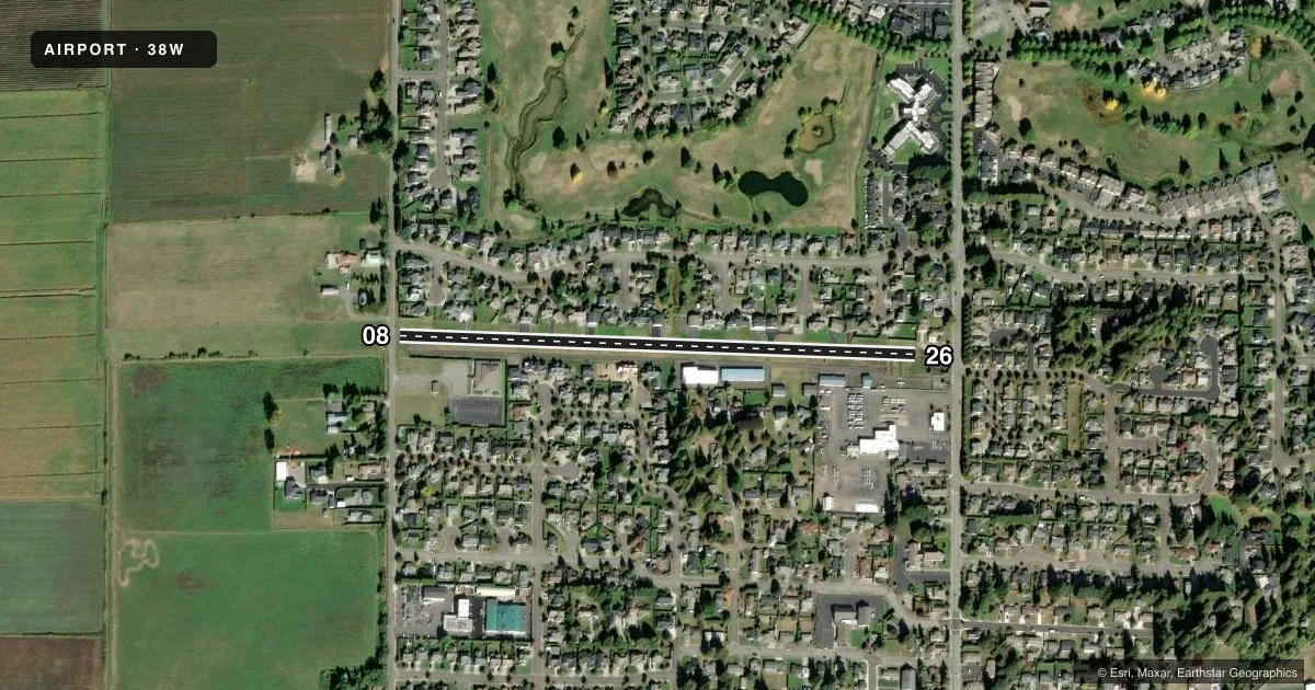
Airport sketch
Runways drawn to scale from FAA survey coordinates, rendered over satellite imagery. Not for navigation.
Approaches & charts
Services on the field
Fuel grades, oxygen, maintenance, ramp storage and lighting — as declared to the FAA by the airport operator.
Fuel & services
- Fuel
- 100LL
- Oxygen (bottled)
- Not available
- Oxygen (bulk)
- Not available
- Airframe repair
- Not available
- Power plant repair
- Not available
Ramp & ground
- Transient storage
- Tie-down
- Landing fee
- No fee published
- Customs
- Not available
- Lighting schedule
- SEE RMK
- Beacon schedule
- SEE RMK
- Beacon
- White / Green (civil land)(WG)
- Wind indicator
- Lighted
- Segmented circle
- Yes
Fuel & FBOs
Cheapest 100LL and Jet A on the field and nearby. Always confirm with the FBO before taxi.
Airport notes
Surface conditions, obstructions, local procedures, lighting outages and other notes published with each FAA cycle.
General notes
- REPORT ON DOWNWIND ON 122.9
- 1850 FT BTN THR LGTS; RWY 08 THR LGTS LOCATED 134 FT PRIOR TO DSPLCD THR.
- AVOID NIGHT LDNGS TO RWY 26 - NIGHT LDNGS SHOULD BE PERFORMED ON RWY 08 - WINDS PERMITTING.
- THR RELCTD 155 FT FOR NIGHT OPNS; RWY 26 THR RELCTD 434 FT FOR NIGHT OPNS; 1871 FT LGTD AT NIGHT.
- EXPOSED DITCH RWY 08/26.
- FLY PAPI ON ALL APROACHES TO RWY 08
- RUN-UPS NOT PERMITTED ON RUNWAY 26 TURN AROUND TAXIWAY
- WSDOT KIOSK LCTD AT FUEL STN.
- BICYCLES AVBL IN PILOT'S LOUNGE.
- APCH/DEP SVC PRVDD BY VICTORIA TRML ON 132.7/290.8. (604) 586-4560.
- ACFT WITH 40 FT WING SPAN ADZD TO BACK TAXI AND NOT TO USE WEST TWY.
- STRUCTURES AND TREES IN PRI SFCS.
Lighting notes
- USE 3 CLICKS TO ACTVT ROTG BCN- CTAF.
- USE 3 CLICKS TO ACTVT MIRL RWY 08/26 - CTAF.
Fuel notes
- 100LLAUTOMATED CREDIT CARD SYSTEM FOR FUEL.
Runway surface & condition
- 08/26NO WHITE/RED LIGHTS PAST DISPLACED THRESHOLD.
Approach & departure obstructions
- 08ROAD AT 23 FT, DITCH 43 FT LEFT AND 14 FT FM THR.
- 26TREES AT 200 FT; 9 FT TREES 60 FT RIGHT; ROAD 101 FT LEFT; 10 FT BUSHES 164 FT FM RWY END.
- 08APCH SLOPE 16:1 TO +17 FT ROAD AT 272 FT FROM DSPLCD THR.
- 26APCH SLOPE 18:1 TO DSPLCD THLD; 84 FT TREES 1116 FT 0B.
Other notes
- ESTABD PRIOR TO 15 MAY 1959.
- AUTOMATED UNICOM; 3 CLICKS.
- MANAGERAIRPORT PHYSICAL ADDRESS: 8635 DEPOT ROAD, LYNDEN, WA 98264
- MANAGERALTN CTC: HEATHER SYTSMA AND MIRIAM KENTNER - PUBLIC WORKS OFC MGR.
VFR map & nearby airports
VFR sectional. Tap any ICAO chip to open that airport.
Key facts · 38W
Answer card- ICAO
- 38W
- Name
- LYNDEN MUNI/JANSEN FLD
- Location
- LYNDEN, WASHINGTON
- Elevation
- 106 ft MSL
- Traffic pattern altitude
- 1,106 ft MSL (1,000 AGL)
- Control tower
- Non-towered (use CTAF)
- Total runways
- 1
- Longest runway
- 08/26 · 2,425 ft
- Published ILS approaches
- 0
- Published frequencies
- 1
- Magnetic variation
- 16°
- Current flight rules
- VFR
- Current wind
- 180° at 7 kt
- Favored runway now
- RWY 08
LYNDEN MUNI/JANSEN FLD sits in Lynden, Washington. Field elevation is 106 ft MSL. The airport has one runway, 08/26, which is 2,425 ft long. There is no control tower. CTAF is 122.9. No ILS approaches are published here.
Pattern altitude is not published, so use the standard 1,000 ft AGL for light piston operations unless the current FAA Chart Supplement says otherwise. That puts the pattern at 1,106 ft MSL based on the field elevation. The on-field FBO is Lynden Municipal Airport. It carries AVGAS 100LL. Call (360) 354-3446 before arrival if you need current field details.
Read the remarks before you go. The runway 08 side has nearby road and ditch obstacles. The runway 26 side has trees close in on the approach path. Night use needs extra care here. The threshold was relocated for night operations. Only 1,871 ft is lighted at night. The published note also says to avoid night landings to runway 26 when winds allow. Run-ups are not permitted on the runway 26 turnaround taxiway. For a first visit, plan a conservative approach, brief the displaced thresholds and verify any current local notes with the airport operator or the current FAA Chart Supplement.