METAR & TAF 1RL
1RL does not publish a METAR.
Showing the nearest reporting station: CYVR (VANCOUVER INTL) · 13.7 NM away. Conditions at 1RL may differ.
METAR · CYVR
Observed 15:15Z
CYVR 271515Z 13007KT 8SM -RA FEW015 OVC042 16/16 A3005 RMK SC2SC6 SLP179
- Wind
- 130° @ 7 kt
- Visibility
- 8 SM
- Temp / Dew
- 16°C / 16°C
- Altimeter
- 30.05 inHg
- Clouds
- OVC
- Density alt
- -28 ft
- Ceiling
- 4,200 ft AGL
- Rules
- VFR
Airport info & contacts
Manager on record, flight service, ARTCC, attendance schedule and pattern altitude — published by the FAA and refreshed every 28 days.
Location
- From city
- 1 NM SW
- VFR sectional
- SEATTLE
- ARTCC
- ZSE · SEATTLE
- NOTAM facility
- SEA (NOTAM-D)
Airport manager
- Name
- BOB GRANLEY
- Phone
- (778) 846-4311
- Address
- 693 HIGHLAND DRIVE, POINT ROBERTS WA 98281
Flight service · Hours
- FSS SEA
- SEATTLE1-800-WX-BRIEF
- Attendance
- MON-FRI · 0900-1700
Frequencies
Tap any row to copy the frequency to your clipboard.
Runways & pattern
Full pagePattern entry · RWY 16
RIGHT TRAFFICRunway end performance
| End | TORA | TODA | ASDA | LDA | VGSI | Approach lights | Obstruction |
|---|---|---|---|---|---|---|---|
| 16 | — | — | — | — | — | — | 120', trees, 752' from thr, 0' R of cntrln, slope 6 |
| 34 | — | — | — | — | — | — | 28', trees, 203' from thr, 0' R of cntrln, slope 8 |
Declared distances in feet. TORA = takeoff run available, TODA = takeoff distance, ASDA = accelerate-stop, LDA = landing distance.
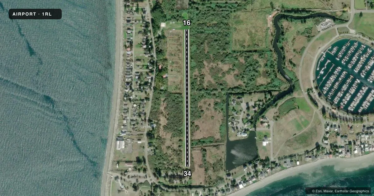
Airport sketch
Runways drawn to scale from FAA survey coordinates, rendered over satellite imagery. Not for navigation.
Approaches & charts
Services on the field
Fuel grades, oxygen, maintenance, ramp storage and lighting — as declared to the FAA by the airport operator.
Fuel & services
- Fuel
- Not available
Ramp & ground
- Transient storage
- Not published
- Landing fee
- Yes
- Wind indicator
- Yes
- Segmented circle
- No
Fuel & FBOs
Cheapest 100LL and Jet A on the field and nearby. Always confirm with the FBO before taxi.
Airport notes
Surface conditions, obstructions, local procedures, lighting outages and other notes published with each FAA cycle.
General notes
- TRAFFIC PATTERN WEST OF FLD OVER WATER.
- NOISE ABATEMENT PROC IN EFCT, CTC AMGR FOR DTLS AT 778-846-4311.
- WHEN ABLE LAND TO THE 'N' AND DEPART TO THE 'S'.
- BOUNDARY BAY (CZBB) ATIS AVBL, 125.5 OR 1-877-517-2847, BOUNDARY BAY TWR 118.1 OR 127.6.
- TKO TO THE SOUTH, 15 DEGREES RIGHT TURN FOR NOISE ABATEMENT
- TKO TO THE NORTH, TURN 30 DEGREES WEST AS SOON AS POSSIBLE
- FOR CD CTC VANCOUVER TRML AT 604-586-4571.
- THERE IS NO CAMPING ON THE PROPERTY.
Other notes
- PRKG AVBL ON GRASS AREA, NO TIE DOWNS PRVD. THERE IS A $10 LNDG FEE FOR VISITING ACFT. TSNT ACFT FOR OVNGT TIE DOWNS IS $15 PER NIGHT. PAYMENT DROP BOX IS INSIDE HNGR ON EAST WALL. YOU MUST TEXT FOR PMSN FIRST, SO THAT THE NR OF PLANES CAN BE CONTROLLED ON THE FLD. PHONE NR: 778-846-4311.
VFR map & nearby airports
VFR sectional. Tap any ICAO chip to open that airport.
Key facts · 1RL
Answer card- ICAO
- 1RL
- Name
- POINT ROBERTS AIRPARK
- Location
- POINT ROBERTS, WASHINGTON
- Elevation
- 11 ft MSL
- Traffic pattern altitude
- 1,011 ft MSL (1,000 AGL)
- Control tower
- Non-towered (use CTAF)
- Total runways
- 1
- Longest runway
- 16/34 · 2,265 ft
- Published ILS approaches
- 0
- Published frequencies
- 2
- Magnetic variation
- 19°
- Current flight rules
- VFR
- Current wind
- 130° at 7 kt
- Favored runway now
- RWY 16
Point Roberts Airpark sits in Point Roberts, Washington. Field elevation is 11 ft MSL. The airport has one runway. Runway 16/34 is 2,265 ft of turf, with magnetic headings of 180° and 360°. There is no control tower. No ILS approaches are published. The pattern altitude is not published, so use the standard 1,000 ft AGL pattern for light piston operations unless the current Chart Supplement says otherwise.
This is a small field with tight local procedures. Published remarks say parking is on the grass with no tie-downs provided. Visiting aircraft pay a $10 landing fee. Overnight transient tie-downs are $15 per night. You need to text for permission before arrival so the number of aircraft on the field can be controlled. The airport manager can be reached at 778-846-4311.
Noise abatement matters here. Takeoff to the south calls for an immediate 15° right turn. Takeoff to the north calls for a 30° west turn as soon as possible. When able, land to the north and depart to the south. The west side pattern is over water. There are no on-field FBOs listed, so verify fuel and services with the airport operator directly before you go. Boundary Bay ATIS and tower are listed in the remarks for coordination with the local area. For clearance delivery, contact Vancouver Terminal.