METAR & TAF CZBB
CZBB does not publish a METAR.
Showing the nearest reporting station: CYVR (VANCOUVER INTL) · 9.9 NM away. Conditions at CZBB may differ.
METAR · CYVR
Observed 14:00Z
CYVR 271400Z 11008KT 20SM FEW017 BKN056 BKN064 BKN068 OVC180 16/16 A3004 RMK CF1SC5SC1AC1AC2 CF TR SC TR SH DIST N SLP174
- Wind
- 110° @ 8 kt
- Visibility
- 20 SM
- Temp / Dew
- 16°C / 16°C
- Altimeter
- 30.04 inHg
- Clouds
- OVC
- Density alt
- -21 ft
- Ceiling
- 5,600 ft AGL
- Rules
- VFR
Airport info & contacts
Manager on record, flight service, ARTCC, attendance schedule and pattern altitude — published by the FAA and refreshed every 28 days.
Location
- From city
- 9 NM SSE
- VFR sectional
- SEATTLE
- ARTCC
- ZVR · VANCOUVER
- NOTAM facility
- CYVR
Airport manager
- Name
- ALPHA AVIATION INC.
- Phone
- 604-946-5361
- Address
- 7800 ALPHA WAY, DELTA BC
Flight service · Hours
- FSS YKA
- KAMLOOPS FIC
- Attendance
- 0700-2100
Frequencies
Tap any row to copy the frequency to your clipboard.
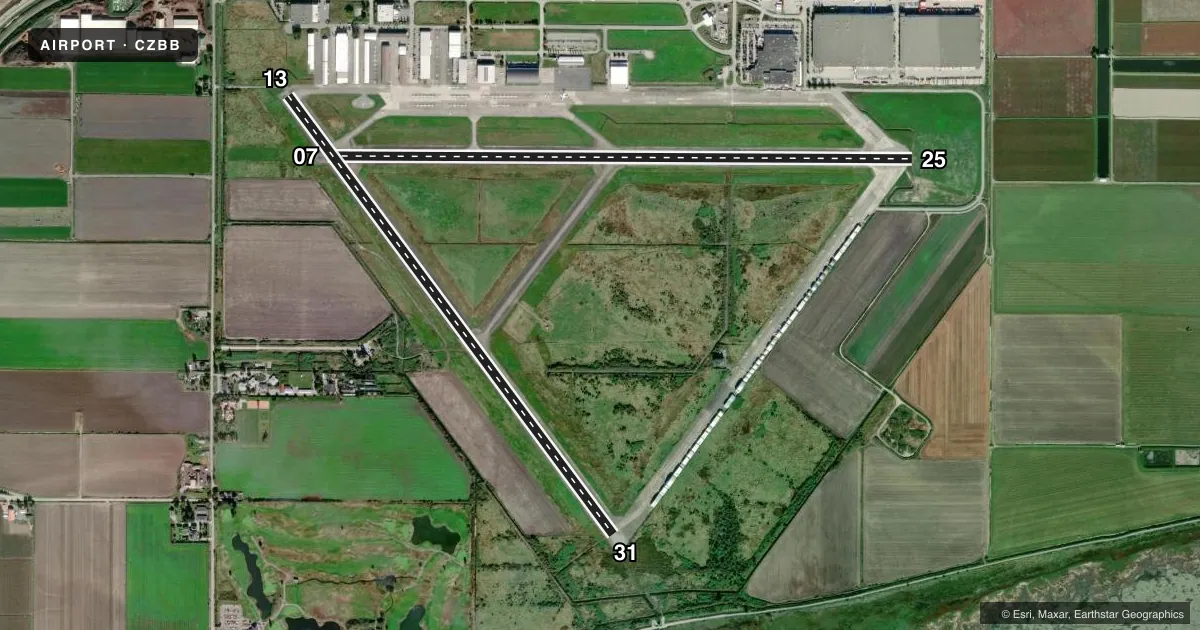
Runways & pattern
Full pagePattern entry · RWY 07
LEFT TRAFFIC| Runway | Heading (°M) | Length | Surface | Traffic |
|---|---|---|---|---|
| 07/25Favored | 73° / 253° | 6,008 ft | ASPH | 25 R |
| 13/31 | 126° / 306° | 5,605 ft | ASPH | Standard L |
Runway end performance
| End | TORA | TODA | ASDA | LDA | VGSI | Approach lights | Obstruction |
|---|---|---|---|---|---|---|---|
| 07 | 6,008' | 6,008' | 6,008' | 6,008' | — | NSTD | — |
| 25 | 6,008' | 6,992' | 6,008' | 5,006' | — | — | 10', road, 190' from thr, 100' R of cntrln |
| 13 | 5,605' | 5,933' | 5,605' | 4,949' | — | NSTD | — |
| 31 | 5,605' | 5,933' | 5,605' | 5,605' | — | NSTD | — |
Declared distances in feet. TORA = takeoff run available, TODA = takeoff distance, ASDA = accelerate-stop, LDA = landing distance.
Airport sketch
Runways drawn to scale from FAA survey coordinates, rendered over satellite imagery. Not for navigation.
Approaches & charts
Services on the field
Fuel grades, oxygen, maintenance, ramp storage and lighting — as declared to the FAA by the airport operator.
Fuel & services
- Fuel
- 100LLA1
- Oxygen (bulk)
- HIGH/LOW
- Airframe repair
- Major
- Power plant repair
- Major
- Other services
- AVNCS,CHTR,INSTR,RNTL
Ramp & ground
- Transient storage
- Tie-down
- Hangar
- Customs
- Not available
- Lighting schedule
- SS-SR
- Wind indicator
- Lighted
Fuel & FBOs
Cheapest 100LL and Jet A on the field and nearby. Always confirm with the FBO before taxi.
Airport notes
Surface conditions, obstructions, local procedures, lighting outages and other notes published with each FAA cycle.
Other notes
- PILOT SUPPY ROPE.
VFR map & nearby airports
VFR sectional. Tap any ICAO chip to open that airport.
Key facts · CZBB
Answer card- ICAO
- CZBB
- Name
- VANCOUVER/BOUNDARY BAY
- Location
- BOUNDARY BAY
- Elevation
- 6 ft MSL
- Traffic pattern altitude
- 1,006 ft MSL (1,000 AGL)
- Control tower
- Non-towered (use CTAF)
- Total runways
- 2
- Longest runway
- 07/25 · 6,008 ft
- Published ILS approaches
- 0
- Published frequencies
- 4
- Magnetic variation
- 17°
- Current flight rules
- VFR
- Current wind
- 110° at 8 kt
- Favored runway now
- RWY 07
Vancouver/Boundary Bay sits at Boundary Bay near the U.S. border in British Columbia. Field elevation is 6 ft MSL. The airport has 2 asphalt runways. The longest is 6,008 ft on runway 07/25. Runway 13/31 is 5,605 ft. There is no control tower. Published frequencies include ATIS 125.5, ground 124.3. Local traffic uses 118.1 and 127.6.
No ILS approaches are published here. Pattern altitude is not published. Use the standard 1,000 ft AGL pattern for light piston operations unless current airport information says otherwise. That puts the pattern at about 1,006 ft MSL based on the field elevation. Check the current Chart Supplement before you go. The published remarks also note pilot supply rope. Plan for normal securement needs on the ramp.
For a first-time arrival, the main things to sort out are the non-towered flow, the two runway options and the lack of published ILS. With the field sitting just above sea level, density altitude is usually not the main issue. Traffic and local procedures are more likely to matter. Use the current Chart Supplement and listen carefully on the published frequencies before joining. There are no on-field FBOs listed in the facts. Contact the airport operator directly or call the field on CTAF for current service details.