METAR & TAF CYYJ
Current METAR
Observed 16:00Z
CYYJ 271600Z 14008KT 15SM FEW014 BKN067 BKN100 16/15 A3005 RMK ST1AC5AC2 ST TR SLP177
- Wind
- 140° @ 8 kt
- Visibility
- 15 SM
- Temp / Dew
- 16°C / 15°C
- Altimeter
- 30.05 inHg
- Clouds
- BKN
- Density alt
- 38 ft
- Ceiling
- 6,700 ft AGL
- Rules
- VFR
Airport info & contacts
Manager on record, flight service, ARTCC, attendance schedule and pattern altitude — published by the FAA and refreshed every 28 days.
Location
- From city
- 12 NM NNW
- ARTCC
- ZVR · VANCOUVER
- NOTAM facility
- CYYJ
Airport manager
Flight service · Hours
- FSS YKA
- KAMLOOPS FIC
Frequencies
Tap any row to copy the frequency to your clipboard.
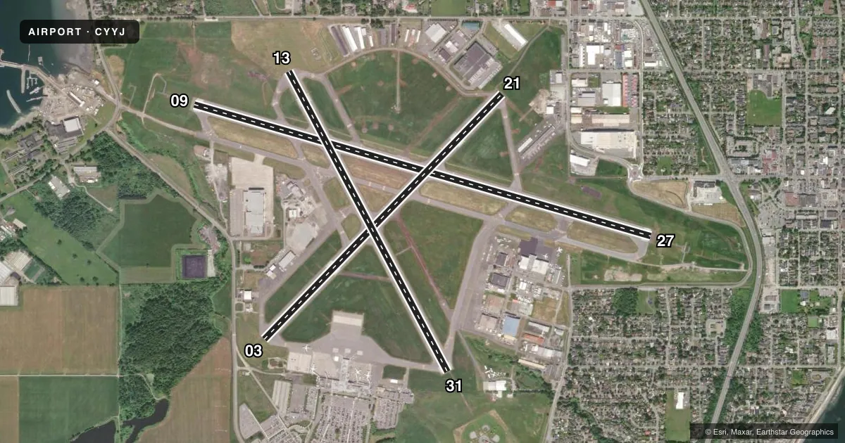
Runways & pattern
Full pagePattern entry · RWY 13
LEFT TRAFFIC| Runway | Heading (°M) | Length | Surface | Traffic |
|---|---|---|---|---|
| 09/27 | 87° / 267° | 6,998 ft | ASPH | Standard L |
| 03/21 | 25° / 205° | 5,026 ft | ASPH | Standard L |
| 13/31Favored | 133° / 313° | 5,001 ft | ASPH | Standard L |
Runway end performance
| End | TORA | TODA | ASDA | LDA | VGSI | Approach lights | Obstruction |
|---|---|---|---|---|---|---|---|
| 09 | — | — | — | — | — | ODALS | — |
| 27 | — | — | — | — | — | SSALR | — |
| 13 | — | — | — | — | — | ODALS | — |
Declared distances in feet. TORA = takeoff run available, TODA = takeoff distance, ASDA = accelerate-stop, LDA = landing distance.
Airport sketch
Runways drawn to scale from FAA survey coordinates, rendered over satellite imagery. Not for navigation.
Approaches & charts
Services on the field
Fuel grades, oxygen, maintenance, ramp storage and lighting — as declared to the FAA by the airport operator.
Fuel & services
- Fuel
- 100LLA1
- Oxygen (bulk)
- HIGH/LOW
- Airframe repair
- Major
- Power plant repair
- Major
Ramp & ground
- Transient storage
- Not published
- Customs
- Not available
Fuel & FBOs
Cheapest 100LL and Jet A on the field and nearby. Always confirm with the FBO before taxi.
Airport notes
Surface conditions, obstructions, local procedures, lighting outages and other notes published with each FAA cycle.
VFR map & nearby airports
VFR sectional. Tap any ICAO chip to open that airport.
Key facts · CYYJ
Answer card- ICAO
- CYYJ
- Name
- VICTORIA INTL
- Location
- VICTORIA
- Elevation
- 64 ft MSL
- Traffic pattern altitude
- 1,064 ft MSL (1,000 AGL)
- Control tower
- Towered · 1400-0800Z++
- Total runways
- 3
- Longest runway
- 09/27 · 6,998 ft
- Published ILS approaches
- 0
- Published frequencies
- 2
- Magnetic variation
- 19°
- Current flight rules
- VFR
- Current wind
- 140° at 8 kt
- Favored runway now
- RWY 13
Victoria Intl sits in Victoria, British Columbia. Field elevation is 64 ft MSL. The airport has three asphalt runways. The longest is 09/27 at 6,998 ft. Tower service is published from 1400-0800Z++. No ILS approaches are published, so plan with the current instrument chart and expect to use other published procedures if needed. Pattern altitude is not published. A standard 1,000 ft AGL pattern is often used for light piston traffic. That would put it near 1,064 ft MSL here. Verify the current pattern and local procedures before you go.
This is a controlled airport with ATIS on 118.8 and ground or clearance on 121.9. Runway headings are 13/31 at 152° and 332°, 09/27 at 106° and 286° and 03/21 at 44° and 224°. Magnetic variation is 19°. There are no on-field FBOs listed in the facts, so contact the airport operator or the field directly for fuel and handling availability before arrival. For a first-time visit, pay attention to the tower hours, the lack of a published ILS and the fact that the field sits close to sea level. That usually keeps density altitude manageable. Coastal weather can still change the picture fast.