METAR & TAF 13W
13W does not publish a METAR.
Showing the nearest reporting station: KOKH (DELAURENTIS) · 9.5 NM away. Conditions at 13W may differ.
METAR · KOKH
Observed 16:12Z
KOKH 271612Z AUTO 15010KT 10SM OVC013 17/14 A3007 RMK AO2
- Wind
- 150° @ 10 kt
- Visibility
- 10 SM
- Temp / Dew
- 17°C / 14°C
- Altimeter
- 30.07 inHg
- Clouds
- OVC
- Density alt
- 234 ft
- Ceiling
- 1,300 ft AGL
- Rules
- MVFR
Airport info & contacts
Manager on record, flight service, ARTCC, attendance schedule and pattern altitude — published by the FAA and refreshed every 28 days.
Location
- From city
- 3 NM NW
- VFR sectional
- SEATTLE
- ARTCC
- ZSE · SEATTLE
- NOTAM facility
- SEA (NOTAM-D)
Airport manager
- Name
- STEVEN & NORMA KNOPP
- Phone
- 360-629-4812
- Address
- 1212 MOORE RD #2, CAMANO ISLAND WA 98282
Flight service · Hours
- FSS SEA
- SEATTLE1-800-WX-BRIEF
- Attendance
- MON-THUR · 0900-1300
Frequencies
Tap any row to copy the frequency to your clipboard.
Runways & pattern
Full pagePattern entry · RWY 16
RIGHT TRAFFICRunway end performance
| End | TORA | TODA | ASDA | LDA | VGSI | Approach lights | Obstruction |
|---|---|---|---|---|---|---|---|
| 16 | — | — | — | — | — | — | 60', tree, 200' from thr, 90' R of cntrln, slope 0 |
| 34 | — | — | — | — | — | — | 20', brush, 200' from thr, 20' R of cntrln, slope 0 |
Declared distances in feet. TORA = takeoff run available, TODA = takeoff distance, ASDA = accelerate-stop, LDA = landing distance.
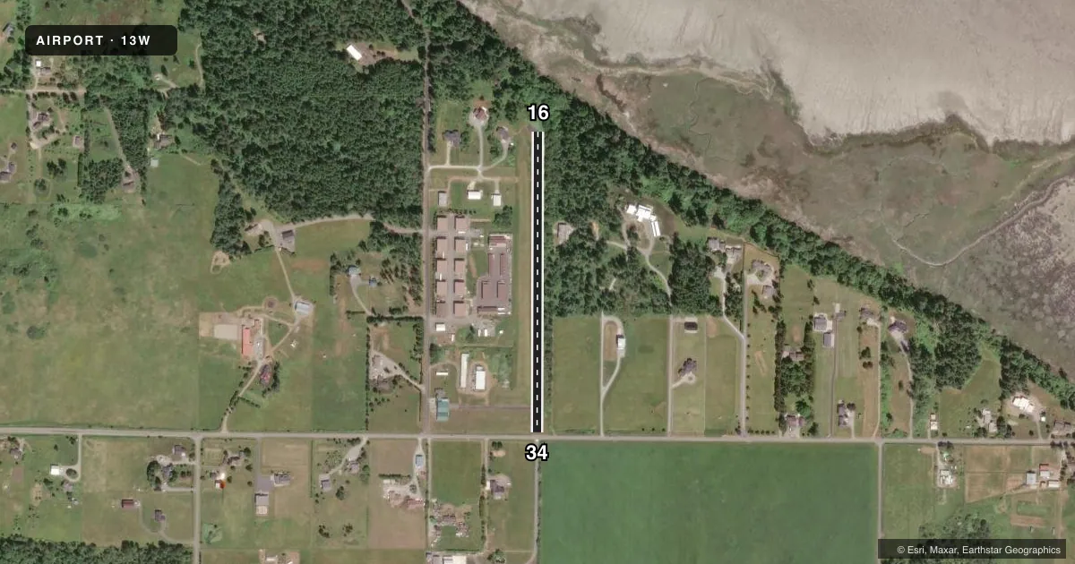
Airport sketch
Runways drawn to scale from FAA survey coordinates, rendered over satellite imagery. Not for navigation.
Approaches & charts
Services on the field
Fuel grades, oxygen, maintenance, ramp storage and lighting — as declared to the FAA by the airport operator.
Fuel & services
- Fuel
- Not available
- Oxygen (bottled)
- Not available
- Oxygen (bulk)
- Not available
- Airframe repair
- Not available
- Power plant repair
- Not available
Ramp & ground
- Transient storage
- Tie-down
- Customs
- Not available
- Wind indicator
- Yes
- Segmented circle
- No
Fuel & FBOs
Cheapest 100LL and Jet A on the field and nearby. Always confirm with the FBO before taxi.
Airport notes
Surface conditions, obstructions, local procedures, lighting outages and other notes published with each FAA cycle.
General notes
- STUDENT LANDINGS NOT RCMDD UNLESS ACCOMPANIED BY AN INSTRUCTOR.
- FST 1049 FT OF RWY 16 HAS 3 PCT UPHILL SLP TO THE SOUTH.
- PARALLEL DRIVEWAY ADJACENT TO RY 16/34.
- DO NOT TAXI ON GRASS OCT - MAY.
- 50 FT TREES, 60 FT E OF CNTRLN IN PRI SFC.
- NO TAKE-OFFS OR LANDINGS DURING HOURS OF DARKNESS.
- FOR CD CTC WHIDBEY APCH AT 360-257-3310.
Approach & departure obstructions
- 167 FT BRUSH, 21 FT L FR THLD; 45 FT TREES, 50 FT L FR THLD; 10FT BRUSH, 67 FT CNTRD FR THLD.
- 34ROAD AT 22 FT; 4 FT CABLE FENCE AT 55 FT; 10 FT BRUSH AT 55 FT; 34 FT POLE WITH WIRES AT 22 FT, 90 FT RIGHT; ROW OF TIRES AT 13 FT.
Other notes
- PILOTS BRING OWN TIE-DOWNS.
VFR map & nearby airports
VFR sectional. Tap any ICAO chip to open that airport.
Key facts · 13W
Answer card- ICAO
- 13W
- Name
- CAMANO ISLAND AIRFIELD
- Location
- STANWOOD, WASHINGTON
- Elevation
- 145 ft MSL
- Traffic pattern altitude
- 1,145 ft MSL (1,000 AGL)
- Control tower
- Non-towered (use CTAF)
- Total runways
- 1
- Longest runway
- 16/34 · 1,750 ft
- Published ILS approaches
- 0
- Published frequencies
- 1
- Magnetic variation
- 21°
- Current flight rules
- MVFR
- Current wind
- 150° at 10 kt
- Favored runway now
- RWY 16
Camano Island Airfield sits near Stanwood, Washington. Field elevation is 145 ft MSL. The airport has one runway, 16/34, at 1,750 ft of asphalt. There is no control tower. CTAF is 122.9. No ILS approaches are published here.
Pattern altitude is not published. Use 1,000 ft AGL as the standard light-piston pattern reference unless the current Chart Supplement says otherwise. The field sits in a low-elevation coastal setting, so expect a short runway and pay close attention to performance, wind and runway remaining. Published remarks also matter here. Runway 16 has a 3 percent uphill slope for the first 1,049 ft. Runway 34 has several threshold-area obstructions, including a road, fence, brush, a pole with wires and tires. There are also 50-foot trees east of the centerline in the primary surface. No takeoffs or landings are permitted during hours of darkness. Student landings are not recommended unless an instructor is aboard. Pilots must bring their own tie-downs. For clearance delivery, contact Whidbey Approach at 360-257-3310.