METAR & TAF KAWO
Current METAR
Observed 17:07Z
KAWO 271707Z AUTO 13010KT 10SM BKN022 OVC100 19/14 A3008 RMK AO2 $
- Wind
- 130° @ 10 kt
- Visibility
- 10 SM
- Temp / Dew
- 19°C / 14°C
- Altimeter
- 30.08 inHg
- Clouds
- OVC
- Density alt
- 457 ft
- Ceiling
- 2,200 ft AGL
- Rules
- MVFR
Airport info & contacts
Manager on record, flight service, ARTCC, attendance schedule and pattern altitude — published by the FAA and refreshed every 28 days.
Location
- From city
- 3 NM SW
- VFR sectional
- SEATTLE
- Pattern altitude
- 1,058 ft AGL · 1,200 ft MSL
- ARTCC
- ZSE · SEATTLE
- NOTAM facility
- AWO (NOTAM-D)
Airport manager
- Name
- MARTY WRAY
- Phone
- 360-403-3471
- Address
- 18204 59TH AVE NE, STE A, ARLINGTON WA 98223
Flight service · Hours
- FSS SEA
- SEATTLE1-800-WX-BRIEF
- Attendance
- M-F · 0800-1700
Frequencies
Tap any row to copy the frequency to your clipboard.
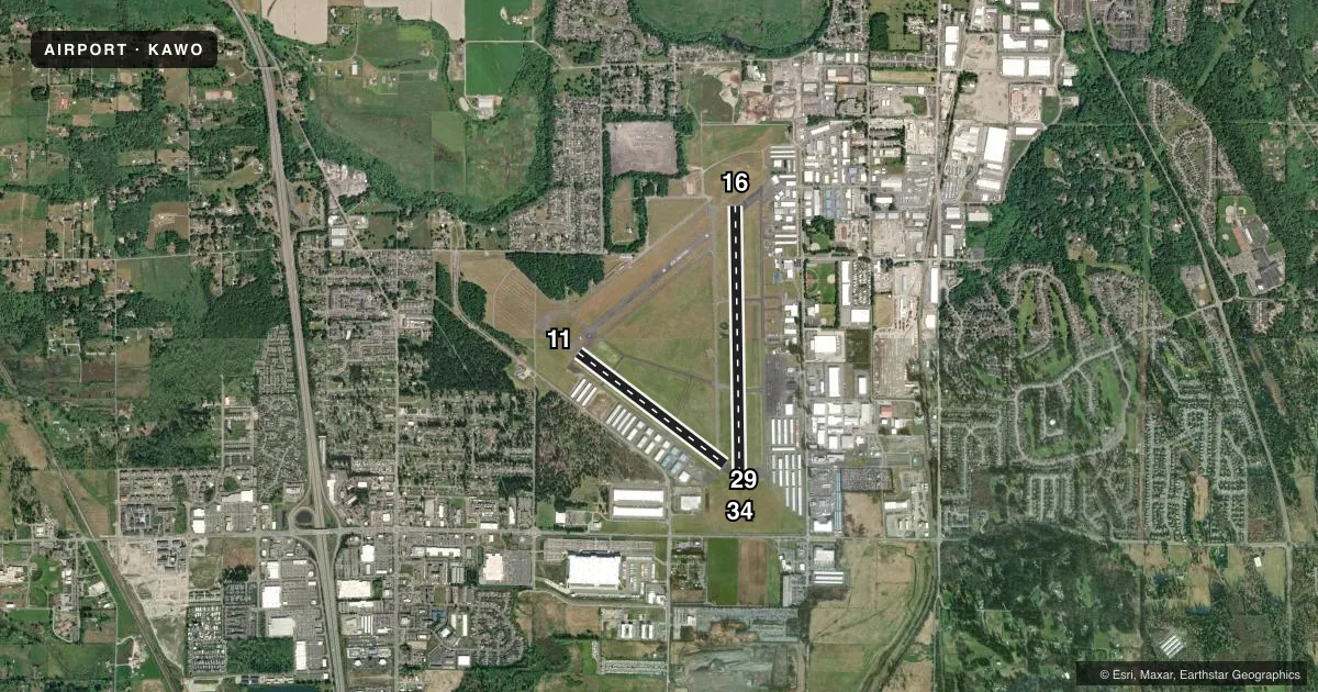
Runways & pattern
Full pagePattern entry · RWY 11
RIGHT TRAFFIC| Runway | Heading (°M) | Length | Surface | Traffic |
|---|---|---|---|---|
| 16/34 | 162° / 342° | 5,332 ft | ASPH | 16 R |
| 11/29Favored | 110° / 290° | 3,498 ft | ASPH | 11 R |
Runway end performance
| End | TORA | TODA | ASDA | LDA | VGSI | Approach lights | Obstruction |
|---|---|---|---|---|---|---|---|
| 16 | — | — | — | — | PAPI 2-box left(3°) | — | 92', tree, 2287' from thr, 200' R of cntrln, slope 22 |
| 34 | — | — | — | — | PAPI 2-box left(3°) | MALS | — |
| 11 | — | — | — | — | PAPI 2-box left(3.5°) | — | — |
| 29 | — | — | — | — | PAPI 2-box left(4°) | — | 176', tree, 3967' from thr, 465' R of cntrln, slope 21 |
Declared distances in feet. TORA = takeoff run available, TODA = takeoff distance, ASDA = accelerate-stop, LDA = landing distance.
Airport sketch
Runways drawn to scale from FAA survey coordinates, rendered over satellite imagery. Not for navigation.
Approaches & charts
ILS · 1
Services on the field
Fuel grades, oxygen, maintenance, ramp storage and lighting — as declared to the FAA by the airport operator.
Fuel & services
- Fuel
- 100LLA
- Oxygen (bottled)
- Not available
- Oxygen (bulk)
- Not available
- Airframe repair
- Major
- Power plant repair
- Major
- Other services
- AMB,AVNCS,CARGO,CHTR,GLD,INSTR,RNTL,SALES,SURV,TOW
Ramp & ground
- Transient storage
- Tie-down
- Landing fee
- No fee published
- Customs
- Not available
- Lighting schedule
- SEE RMK
- Beacon schedule
- SS-SR
- Beacon
- White / Green (civil land)(WG)
- Wind indicator
- Lighted
- Segmented circle
- Yes
Fuel & FBOs
Cheapest 100LL and Jet A on the field and nearby. Always confirm with the FBO before taxi.
Airport notes
Surface conditions, obstructions, local procedures, lighting outages and other notes published with each FAA cycle.
General notes
- GLIDER OPERATIONS AT ARPT DAILY.
- ULTRALIGHT AND POWERED PARACHUTE OPS DAILY WEST OF RWY 16/34
- WILDLIFE ON AND INVOF ARPT. ALTERNATE PHONE NUMBER FOR AIRPORT: 360-403-3470
- WINTER WEATHER OPERATIONS AND REPORTING MONDAY-FRIDAY 1600-0000Z.
- FOR ADDNL DETAILS & RULES ON LOCAL PROCS CALL 360-403-3470.
- FOR CD WHEN ATCT IS CLSD CTC SEATTLE APCH AT 206-214-4722.
- GLIDER TURF PARALLEL EAST OF RWY 16/34, FULL LENGTH DIMENSIONS 3450 FT X 145 FT.
- RWY 11/29 TURF LCTD BTN D2 AND D3 DIMENSIONS 1400 FT X 100 FT.
Lighting notes
- REIL RWY 11 & 29 OPR SS-SR; PAPI RWY 11, 16, 29 & 34 OPR CONSLY. ACTVT MALS RWY 34; REILS RWY 16; RWY 16/34 EDGE LIGHTS; TWY LGTS CTAF.
Fuel notes
- 100LL100L FUEL AVBL 24 HR CREDIT CARD SVC.
- APHONE 360-435-5700 FOR AFTER HRS SVC.
Runway surface & condition
- 16/34RWY 34 CALM WIND RWY.
Other notes
- EXISTED PRIOR TO 1959.
- TPA FOR ULTRALGTS 542 (400), HELICOPTERS 642 (500).
- PILOTS PROVIDE OWN ROPES.
VFR map & nearby airports
VFR sectional. Tap any ICAO chip to open that airport.
Key facts · KAWO
Answer card- ICAO
- KAWO
- Name
- ARLINGTON MUNI
- Location
- ARLINGTON, WASHINGTON
- Elevation
- 141.8 ft MSL
- Traffic pattern altitude
- 1,199.8 ft MSL (1,058 AGL)
- Control tower
- Non-towered (use CTAF)
- Total runways
- 2
- Longest runway
- 16/34 · 5,332 ft
- Published ILS approaches
- 1
- Published frequencies
- 4
- Magnetic variation
- 17°
- Current flight rules
- MVFR
- Current wind
- 130° at 10 kt
- Favored runway now
- RWY 11
Arlington Muni is in Arlington, Washington. The field elevation is 141.8 ft MSL. It has two asphalt runways. The longest is runway 16/34 at 5,332 ft. This is a non-towered airport, so pilots use CTAF and follow local procedures. Check the current FAA Chart Supplement for any changes before you go.
The airport has one ILS approach to runway 34. Pattern altitude is 1,199.8 ft MSL, which is 1,058 ft AGL. Arlington Flight Services is on the field. It carries 100LL, Jet A and Jet A Prist. The airport also has daily glider operations. There is a glider turf runway parallel east of runway 16/34. Ultralight and powered parachute traffic also operates daily west of runway 16/34. Expect a busy mix of traffic.
Runway 34 is the calm wind runway. Runway end identifier lights on 11 and 29 run from sunset to sunrise. PAPI is available on 11, 16, 29 and 34. MALSR is on runway 34. Wildlife is reported on and near the airport. If you need local procedure details, call the airport at 360-403-3470 or contact Arlington Flight Services at (360) 435-5700.