METAR & TAF 1S2
1S2 does not publish a METAR.
Showing the nearest reporting station: KAWO (ARLINGTON MUNI) · 22.7 NM away. Conditions at 1S2 may differ.
METAR · KAWO
Observed 15:56Z
KAWO 271556Z AUTO 17007KT 10SM 17/15 A3008 RMK AO2 SLP192 T01720150 $
- Wind
- 170° @ 7 kt
- Visibility
- 10 SM
- Temp / Dew
- 17°C / 15°C
- Altimeter
- 30.08 inHg
- Clouds
- Clear
- Density alt
- 727 ft
- Ceiling
- Unlimited
- Rules
- VFR
Airport info & contacts
Manager on record, flight service, ARTCC, attendance schedule and pattern altitude — published by the FAA and refreshed every 28 days.
Location
- From city
- 0 NM N
- VFR sectional
- SEATTLE
- ARTCC
- ZSE · SEATTLE
- NOTAM facility
- SEA (NOTAM-D)
Airport manager
- Name
- JIM HALE
- Phone
- 360-631-1928
- Address
- P.O. BOX 312, DARRINGTON WA 98241
Flight service · Hours
- FSS SEA
- SEATTLE1-800-WX-BRIEF
- Attendance
- Unattended
Frequencies
Tap any row to copy the frequency to your clipboard.
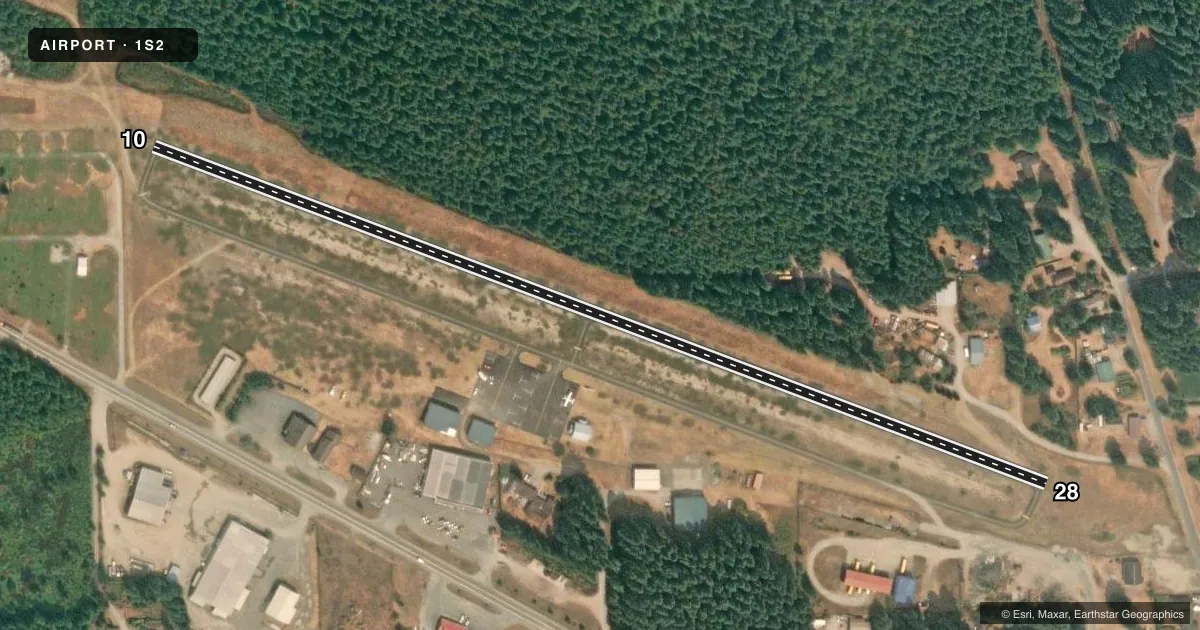
Runways & pattern
Full pagePattern entry · RWY 10
LEFT TRAFFICRunway end performance
| End | TORA | TODA | ASDA | LDA | VGSI | Approach lights | Obstruction |
|---|---|---|---|---|---|---|---|
| 10 | — | — | — | — | — | — | 65', trees, 905' from thr, 0' R of cntrln, slope 10 |
| 28 | — | — | — | — | — | — | 15', road, 305' from thr, 126' R of cntrln, slope 7 |
Declared distances in feet. TORA = takeoff run available, TODA = takeoff distance, ASDA = accelerate-stop, LDA = landing distance.
Airport sketch
Runways drawn to scale from FAA survey coordinates, rendered over satellite imagery. Not for navigation.
Approaches & charts
Services on the field
Fuel grades, oxygen, maintenance, ramp storage and lighting — as declared to the FAA by the airport operator.
Fuel & services
- Fuel
- Not available
- Oxygen (bottled)
- Not available
- Oxygen (bulk)
- Not available
- Airframe repair
- Not available
- Power plant repair
- Not available
Ramp & ground
- Transient storage
- Tie-down
- Landing fee
- No fee published
- Customs
- Not available
- Lighting schedule
- SEE RMK
- Beacon schedule
- SS-SR
- Beacon
- White / Green (civil land)(WG)
- Wind indicator
- Lighted
- Segmented circle
- No
Fuel & FBOs
Cheapest 100LL and Jet A on the field and nearby. Always confirm with the FBO before taxi.
Airport notes
Surface conditions, obstructions, local procedures, lighting outages and other notes published with each FAA cycle.
General notes
- CLSD WHEN SNOW ON RY.
- TURB ON HOT DAYS LNDG W IN TRSN EAST APPROACH.
- TWYS MARKED WITH BLUE REFLECTORS.
- FOR CD CTC SEATTLE ARTCC AT 253-351-3694.
- TWYS ROUGH PAVEMENT WITH SWALES AND DEPRESSIONS.
Lighting notes
- ARPT BCN OTS.
- ACTVT MIRL RWY 10/28 - CTAF.
Runway surface & condition
- 10/28MIRL RY 10/28 OTS INDEFLY.
Approach & departure obstructions
- 10FENCE AT 40 FT, 104 FT R; 3 FT SIGN, 65 FT R, 29 FT FM THLD.
- 28LOGS 78 FT R, ROAD 90 FT R, 35 FT TREES 118 FT R.
Other notes
- ESTABD PRIOR TO 15 MAY 1959.
- PILOTS BRING OWN TIE-DOWNS.
- MANAGERMANAGER'S CELL PHONE NUMBER IS 360-631-1928.
VFR map & nearby airports
VFR sectional. Tap any ICAO chip to open that airport.
Key facts · 1S2
Answer card- ICAO
- 1S2
- Name
- DARRINGTON MUNI
- Location
- DARRINGTON, WASHINGTON
- Elevation
- 553 ft MSL
- Traffic pattern altitude
- 1,553 ft MSL (1,000 AGL)
- Control tower
- Non-towered (use CTAF)
- Total runways
- 1
- Longest runway
- 10/28 · 2,491 ft
- Published ILS approaches
- 0
- Published frequencies
- 1
- Magnetic variation
- 21°
- Current flight rules
- VFR
- Current wind
- 170° at 7 kt
- Favored runway now
- RWY 10
Darrington Muni sits in Darrington, Washington. Field elevation is 553 ft MSL. It has one runway, 10/28, which is 2,491 ft long. There is no control tower. CTAF is 122.9. No ILS approaches are published here.
The pattern altitude is not published. Use the standard 1,000 ft AGL pattern unless the current FAA Chart Supplement says otherwise. The airport beacon is out of service. Medium intensity runway lights are listed for runway 10/28. They are out of service indefinitely. That makes daytime planning important if you are not familiar with the field.
The runway has several published obstructions near both ends. Runway 10 has a fence and a sign near the threshold area. Runway 28 has logs, a road and trees off the right side near the departure end. Taxiways are marked with blue reflectors. The pavement is noted as rough with swales and depressions. The airport is closed when snow is on the runway. There are no on-field FBOs listed, so contact the airport operator or the field directly before arrival. Pilots must bring their own tie-downs. For clearance delivery, Seattle ARTCC is listed in the remarks. This is a small non-towered field with limited published instrument support, so plan conservatively and verify current conditions before you go.