METAR & TAF 3W5
3W5 does not publish a METAR.
Showing the nearest reporting station: KBVS (SKAGIT RGNL) · 26.6 NM away. Conditions at 3W5 may differ.
METAR · KBVS
Observed 16:35Z
KBVS 271635Z AUTO 18009KT 10SM BKN095 19/17 A3007 RMK A01
- Wind
- 180° @ 9 kt
- Visibility
- 10 SM
- Temp / Dew
- 19°C / 17°C
- Altimeter
- 30.07 inHg
- Clouds
- BKN
- Density alt
- 625 ft
- Ceiling
- 9,500 ft AGL
- Rules
- VFR
Airport info & contacts
Manager on record, flight service, ARTCC, attendance schedule and pattern altitude — published by the FAA and refreshed every 28 days.
Location
- From city
- 1 NM S
- VFR sectional
- SEATTLE
- ARTCC
- ZSE · SEATTLE
- NOTAM facility
- SEA (NOTAM-D)
Airport manager
- Name
- JON GUNNARSSON
- Phone
- 206-972-9181
- Address
- PO BOX 39, CONCRETE WA 98237
Flight service · Hours
- FSS SEA
- SEATTLE1-800-WX-BRIEF
- Attendance
- Unattended
Frequencies
Tap any row to copy the frequency to your clipboard.
Runways & pattern
Full pagePattern entry · RWY 07
RIGHT TRAFFICRunway end performance
| End | TORA | TODA | ASDA | LDA | VGSI | Approach lights | Obstruction |
|---|---|---|---|---|---|---|---|
| 07 | — | — | — | — | — | — | 41', trees, 900' from thr, 0' R of cntrln, slope 17 |
| 25 | — | — | — | — | — | — | 44', trees, 720' from thr, 0' R of cntrln, slope 11 |
Declared distances in feet. TORA = takeoff run available, TODA = takeoff distance, ASDA = accelerate-stop, LDA = landing distance.
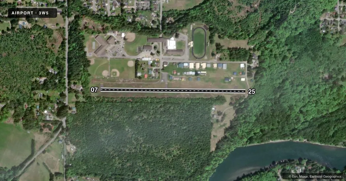
Airport sketch
Runways drawn to scale from FAA survey coordinates, rendered over satellite imagery. Not for navigation.
Approaches & charts
Services on the field
Fuel grades, oxygen, maintenance, ramp storage and lighting — as declared to the FAA by the airport operator.
Fuel & services
- Fuel
- 100LL
- Oxygen (bottled)
- Not available
- Oxygen (bulk)
- Not available
- Airframe repair
- Not available
- Power plant repair
- Not available
- Other services
- CHTR,GLD,INSTR,SALES
Ramp & ground
- Transient storage
- Tie-down
- Landing fee
- No fee published
- Customs
- Not available
- Wind indicator
- Yes
- Segmented circle
- Yes
Fuel & FBOs
Cheapest 100LL and Jet A on the field and nearby. Always confirm with the FBO before taxi.
Airport notes
Surface conditions, obstructions, local procedures, lighting outages and other notes published with each FAA cycle.
General notes
- ALL PATTERNS SOUTH OF ARPT.
- ELK AND DEER FREQUENT BOTH RWY ENDS AND MID-FIELD.
- FOR CD CTC SEATTLE ARTCC AT 253-351-3694.
Runway surface & condition
- H1HELIPAD FOR EMERGENCY USE ONLY.
Approach & departure obstructions
- 25INFREQUENTLY USED ROAD AT 0 FT AND 6 FT BRUSH 80 FT L.
Other notes
- ESTABD PRIOR TO 1959.
- MANAGERJON GUNNARSSON: ARPT REP.
VFR map & nearby airports
VFR sectional. Tap any ICAO chip to open that airport.
Key facts · 3W5
Answer card- ICAO
- 3W5
- Name
- MEARS FLD
- Location
- CONCRETE, WASHINGTON
- Elevation
- 267 ft MSL
- Traffic pattern altitude
- 1,267 ft MSL (1,000 AGL)
- Control tower
- Non-towered (use CTAF)
- Total runways
- 1
- Longest runway
- 07/25 · 2,609 ft
- Published ILS approaches
- 0
- Published frequencies
- 1
- Magnetic variation
- 21°
- Current flight rules
- VFR
- Current wind
- 180° at 9 kt
- Favored runway now
- RWY 07
Mears Field sits in Concrete, Washington. The field elevation is 267 ft MSL. It has one runway. Runway 07/25 is 2,609 ft long with an asphalt surface. There is no control tower. CTAF is 122.9.
No ILS approaches are published here. The traffic pattern altitude is not published, so use the current FAA Chart Supplement for the published value before flying in. The published remarks matter here. All traffic patterns are south of the airport. Elk and deer are frequent at both runway ends and mid-field. There is also an infrequently used road near the departure end of runway 25 with brush close to the runway edge. Helipad H1 is for emergency use only.
There are no on-field FBOs listed. Contact the airport operator directly or call the field on CTAF for current services before you go. For clearance delivery, the published contact is Seattle ARTCC at 253-351-3694. Pilots should plan for a small, non-towered field with wildlife on and near the runway. Check the current FAA Chart Supplement before departure for any updates to remarks or local procedures.