METAR & TAF S43
S43 does not publish a METAR.
Showing the nearest reporting station: KPAE (SEATTLE PAINE FLD INTL) · 7.2 NM away. Conditions at S43 may differ.
METAR · KPAE
Observed 15:53Z
KPAE 271553Z 17013KT 10SM OVC100 18/12 A3008 RMK AO2 SLP185 T01780122
- Wind
- 170° @ 13 kt
- Visibility
- 10 SM
- Temp / Dew
- 18°C / 12°C
- Altimeter
- 30.08 inHg
- Clouds
- OVC
- Density alt
- 190 ft
- Ceiling
- 10,000 ft AGL
- Rules
- VFR
Airport info & contacts
Manager on record, flight service, ARTCC, attendance schedule and pattern altitude — published by the FAA and refreshed every 28 days.
Location
- From city
- 1 NM SW
- VFR sectional
- SEATTLE
- Pattern altitude
- 984 ft AGL · 1,007 ft MSL
- ARTCC
- ZSE · SEATTLE
- NOTAM facility
- SEA (NOTAM-D)
Airport manager
- Name
- CYNTHIA HENDRICKSON
- Phone
- 360-568-1541
- Address
- 9900 AIRPORT WAY, SNOHOMISH WA 98296
Flight service · Hours
- FSS SEA
- SEATTLE1-800-WX-BRIEF
- Attendance
- NOV-MAR · 0730-1630
- APR-OCT · 0730-2100
Frequencies
Tap any row to copy the frequency to your clipboard.
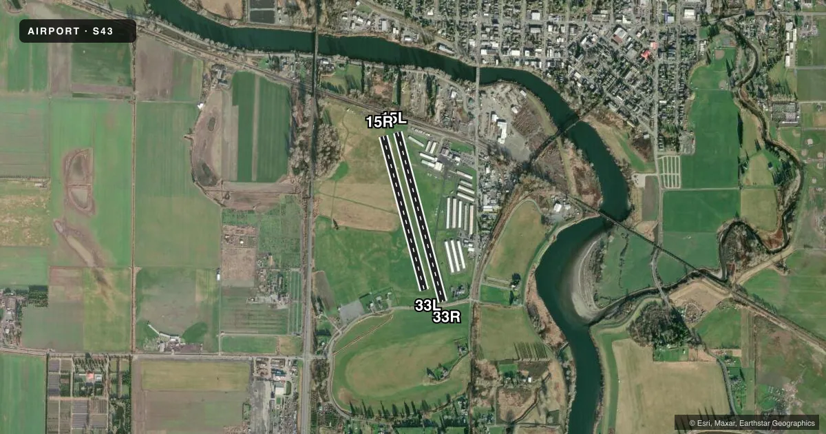
Runways & pattern
Full pagePattern entry · RWY 15L
RIGHT TRAFFIC| Runway | Heading (°M) | Length | Surface | Traffic |
|---|---|---|---|---|
| 15L/33RFavored | 148° / 328° | 2,672 ft | ASPH | 15L R |
| 15R/33L | 148° / 328° | 2,430 ft | TURF | 15R R |
Runway end performance
| End | TORA | TODA | ASDA | LDA | VGSI | Approach lights | Obstruction |
|---|---|---|---|---|---|---|---|
| 15L | — | — | — | — | — | — | 80', trees, 796' from thr, 97' R of cntrln, slope 7 |
| 33R | — | — | — | — | — | — | 97', trees, 1537' from thr, 125' R of cntrln, slope 13 |
| 15R | — | — | — | — | — | — | 67', trees, 1267' from thr, 125' R of cntrln, slope 18 |
| 33L | — | — | — | — | — | — | 110', trees, 2659' from thr, 0' R of cntrln, slope 24 |
Declared distances in feet. TORA = takeoff run available, TODA = takeoff distance, ASDA = accelerate-stop, LDA = landing distance.
Airport sketch
Runways drawn to scale from FAA survey coordinates, rendered over satellite imagery. Not for navigation.
Approaches & charts
Services on the field
Fuel grades, oxygen, maintenance, ramp storage and lighting — as declared to the FAA by the airport operator.
Fuel & services
- Fuel
- 100LLA
- Oxygen (bottled)
- Not available
- Oxygen (bulk)
- Not available
- Airframe repair
- Major
- Power plant repair
- Major
- Other services
- CHTR,INSTR,PAJA,RNTL,SALES
Ramp & ground
- Transient storage
- Tie-down
- Hangar
- Landing fee
- No fee published
- Customs
- Not available
- Lighting schedule
- SS-SR
- Wind indicator
- Yes
- Segmented circle
- No
Fuel & FBOs
Cheapest 100LL and Jet A on the field and nearby. Always confirm with the FBO before taxi.
Airport notes
Surface conditions, obstructions, local procedures, lighting outages and other notes published with each FAA cycle.
General notes
- NOISE ABATEMENT PROCEDURES IN EFFECT; CTC AMGR 360-568-1541.
- HELICOPTER TRNG WEST OF RYS 500 FT & BLO.
- ADDITIONAL PARACHUTE STUDENT DROP ZONE 1 NM E OF ARPT MKD WITH WHITE 'X'. ARRIVING HELICOPTER TRAFFIC APPROACH HELIPADS FROM NE OR SE TO AVOID STUDENT DROP ZONE.
- RYS 15L & 15R CALM WIND RYS.
- PARACHUTE DROP ZONE BETWEEN RY 15L/33R AND MAIN TWY, LARGE GRAVEL CIRCLE.
- FOR CD CTC SEATTLE APCH AT 206-214-4722.
Fuel notes
- 100LLFUEL 24 HR CREDIT CARD SVC AVBL.
Runway surface & condition
- 15R/33LCLOSED NOV 1 - MAY 31.
- 15L/33RNSTD LIRL; THLD LIGHTS 360 DEGS GREEN.
Approach & departure obstructions
- 15LHI VOLTAGE P-LINE 22 FT HIGH 32 FT FM AER 15 & 25 FT FM MARKER LINE AT 106 FT, RAILROAD AT 200FT.
- 33RRD 50' FM THR; +10' FNC POSTS WITH RED LGTS 50' FM THR; 10' LINE WITH LGTS & FLAGS AT 80'.
- 15LAPCH SLOPE 14:1 TO +40 FT PLINE 590 FT FM DSPLCD THLD.
- 15RAPCH SLOPE 14:1 FM DSPLCD THR.
- 33LAPCH SLOPE 6:1 FROM DSPLCD THLD.
- 33RAPCH SLOPE 6:1 FROM DSPLCD THLD.
Other notes
- ESTABD PRIOR TO 15 MAY 1959.
- NON STD TRAFFIC PATTERN INDICATOR LCTD NEAR WIND CONE.
- PILOTS BRING OWN TIEDOWNS.
- ONE WIND CONE ONE TEE.
- MANAGERKANDACEHARVEY@HARVEYFIELD.COM
VFR map & nearby airports
VFR sectional. Tap any ICAO chip to open that airport.
Key facts · S43
Answer card- ICAO
- S43
- Name
- HARVEY FLD
- Location
- SNOHOMISH, WASHINGTON
- Elevation
- 22.8 ft MSL
- Traffic pattern altitude
- 1,006.8 ft MSL (984 AGL)
- Control tower
- Non-towered (use CTAF)
- Total runways
- 2
- Longest runway
- 15L/33R · 2,672 ft
- Published ILS approaches
- 0
- Published frequencies
- 4
- Magnetic variation
- 17°
- Current flight rules
- VFR
- Current wind
- 170° at 13 kt
- Favored runway now
- RWY 15L
Harvey Fld sits in Snohomish, Washington. Field elevation is 22.8 ft MSL. The airport has two runways. The longest is 2,672 ft on 15L/33R. The other runway is 2,430 ft turf on 15R/33L. There is no control tower. CTAF and UNICOM are both 123.0. Seattle Approach handles clearance delivery and approach or departure services on 128.5 and 306.9.
Pattern altitude is 984 ft AGL, which is 1,006.8 ft MSL. No ILS approaches are published here. Snohomish Flying Service is on the field. It carries 100LL and Jet A. Noise abatement procedures are in effect. Contact the airport manager before arrival if you need the current guidance. The Chart Supplement also notes a nonstandard traffic pattern indicator near the wind cone.
This is a low-elevation field, but the runway environment has several things a first-time pilot should brief. There are obstructions near the thresholds on 15L, 33R and 33L. The remarks also mention a parachute drop zone between 15L/33R and the main taxiway. Runway 15L and 15R are calm wind runways. Check the current Chart Supplement before you go. That is the best source for any current noise, traffic pattern, or operational notes.