METAR & TAF 0S9
Current METAR
Observed 06:15Z
K0S9 270615Z AUTO 00000KT 10SM FEW036 SCT055 BKN075 15/15 A3003 RMK AO2
- Wind
- 000° @ 0 kt
- Visibility
- 10 SM
- Temp / Dew
- 15°C / 15°C
- Altimeter
- 30.03 inHg
- Clouds
- BKN
- Density alt
- 0 ft
- Ceiling
- 7,500 ft AGL
- Rules
- VFR
Airport info & contacts
Manager on record, flight service, ARTCC, attendance schedule and pattern altitude — published by the FAA and refreshed every 28 days.
Location
- From city
- 6 NM SW
- VFR sectional
- SEATTLE
- Pattern altitude
- 890 ft AGL · 1,000 ft MSL
- ARTCC
- ZSE · SEATTLE
- NOTAM facility
- SEA (NOTAM-D)
Airport manager
- Name
- ERON BERG, EXECUTIVE DIRECTOR
- Phone
- 360-385-0656
- Address
- PO BOX 1180, PORT TOWNSEND WA 98368
Flight service · Hours
- FSS SEA
- SEATTLE1-800-WX-BRIEF
- Attendance
- 0900-1800
Frequencies
Tap any row to copy the frequency to your clipboard.
Runways & pattern
Full pagePattern entry · RWY 09
RIGHT TRAFFICRunway end performance
| End | TORA | TODA | ASDA | LDA | VGSI | Approach lights | Obstruction |
|---|---|---|---|---|---|---|---|
| 09 | — | — | — | — | PAPI 2-box left(4.25°) | — | 81', trees, 1815' from thr, 0' R of cntrln, slope 19 |
| 27 | — | — | — | — | PAPI 2-box right(4.25°) | — | 76', tree, 1939' from thr, 91' R of cntrln, slope 22 |
Declared distances in feet. TORA = takeoff run available, TODA = takeoff distance, ASDA = accelerate-stop, LDA = landing distance.
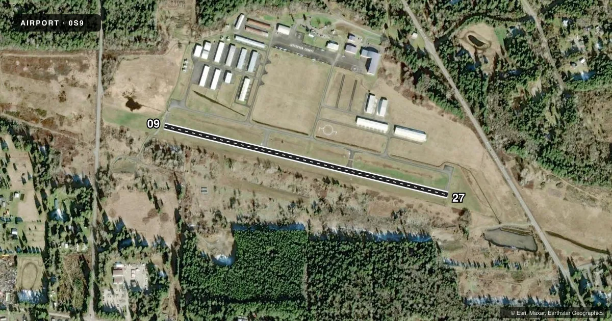
Airport sketch
Runways drawn to scale from FAA survey coordinates, rendered over satellite imagery. Not for navigation.
Approaches & charts
Services on the field
Fuel grades, oxygen, maintenance, ramp storage and lighting — as declared to the FAA by the airport operator.
Fuel & services
- Fuel
- 100LL
- Oxygen (bottled)
- Not available
- Oxygen (bulk)
- Not available
- Airframe repair
- Major
- Power plant repair
- Major
- Other services
- INSTR,RNTL
Ramp & ground
- Transient storage
- Tie-down
- Landing fee
- No fee published
- Customs
- Available
- Lighting schedule
- SEE RMK
- Beacon schedule
- SS-SR
- Beacon
- White / Green (civil land)(WG)
- Wind indicator
- Lighted
- Segmented circle
- Yes
Fuel & FBOs
Cheapest 100LL and Jet A on the field and nearby. Always confirm with the FBO before taxi.
Airport notes
Surface conditions, obstructions, local procedures, lighting outages and other notes published with each FAA cycle.
General notes
- NOISE ABATEMENT PROCS IN EFCT CTC ARPT MGR 360-385-0656. TKOF AND LNDG PROHIBITED ON TURF NEXT TO RWY.
- FOR CD CTC WHIDBEY APCH AT 360-257-3310.
- DEER INVOF RWY.
Lighting notes
- ACTVT REIL RWY 09; PAPI RWY 09 & 27; MIRL RWY 09/27 - CTAF.
Fuel notes
- 100LL100LL AVAILABLE 24 HRS WITH CREDIT CARD. NO CASH SALES.
Approach & departure obstructions
- 09RWY 09 ARE BAFFLED BYD 6.5 DEG LEFT OF RWY CNTRLN DUE TO TRRN.
- 27RWY 27 ARE BAFFLED BYD 6.5 DEG RIGHT OF RWY CNTRLN DUE TO TRRN.
Other notes
- PILOTS BRING OWN TIEDOWNS.
- MANAGEREMAIL: KRISTEN.LONG@TADERA.COM
VFR map & nearby airports
VFR sectional. Tap any ICAO chip to open that airport.
Key facts · 0S9
Answer card- ICAO
- 0S9
- Name
- JEFFERSON COUNTY INTL
- Location
- PORT TOWNSEND, WASHINGTON
- Elevation
- 110.1 ft MSL
- Traffic pattern altitude
- 1,000.1 ft MSL (890 AGL)
- Control tower
- Non-towered (use CTAF)
- Total runways
- 1
- Longest runway
- 09/27 · 3,000 ft
- Published ILS approaches
- 0
- Published frequencies
- 3
- Magnetic variation
- 16°
- Current flight rules
- VFR
- Current wind
- 000° at 0 kt
- Favored runway now
- –
Jefferson County Intl (0S9) sits in Port Townsend, Washington on the Olympic Peninsula. Field elevation is 110.1 ft MSL. The airport has one runway. Runway 09/27 is 3,000 ft asphalt. There is no control tower. Pattern altitude is 890 ft AGL, which is 1,000.1 ft MSL.
No ILS approaches are published here. Clearance delivery is handled through Whidbey Approach at 360-257-3310. CTAF and UNICOM are both 123.0. Approach and departure are on 118.2 with Whidbey. Published remarks call out noise abatement procedures. They also say deer are in the runway area. Takeoff and landing are prohibited on the turf next to the runway. Pilots should also note that runway 09 and 27 approach lights are baffled beyond 6.5 degrees off centerline because of terrain.
100LL is available 24 hours with credit card. No cash sales are listed. Pilots must bring their own tiedowns. There are no on-field FBOs listed in the facts, so verify current services with the airport operator before arrival. For a first visit, plan for the terrain, the noise procedures and the wildlife risk. The field is close to the water. That can make local winds and performance planning worth a close look before you launch.