METAR & TAF W28
W28 does not publish a METAR.
Showing the nearest reporting station: KCLM (WILLIAM R FAIRCHILD INTL) · 12.6 NM away. Conditions at W28 may differ.
METAR · KCLM
Observed 15:06Z
KCLM 271506Z AUTO 00000KT 10SM SCT008 15/14 A3005 RMK AO2 T01500139
- Wind
- 000° @ 0 kt
- Visibility
- 10 SM
- Temp / Dew
- 15°C / 14°C
- Altimeter
- 30.05 inHg
- Clouds
- SCT
- Density alt
- 26 ft
- Ceiling
- Unlimited
- Rules
- VFR
Airport info & contacts
Manager on record, flight service, ARTCC, attendance schedule and pattern altitude — published by the FAA and refreshed every 28 days.
Location
- From city
- 4 NM NW
- VFR sectional
- SEATTLE
- ARTCC
- ZSE · SEATTLE
- NOTAM facility
- SEA (NOTAM-D)
Airport manager
- Name
- ANDY SALLEE
- Phone
- 360-670-3083
- Address
- PO BOX 101, CARLSBORG WA 98324
Flight service · Hours
- FSS SEA
- SEATTLE1-800-WX-BRIEF
- Attendance
- UNATTENDED
Frequencies
Tap any row to copy the frequency to your clipboard.
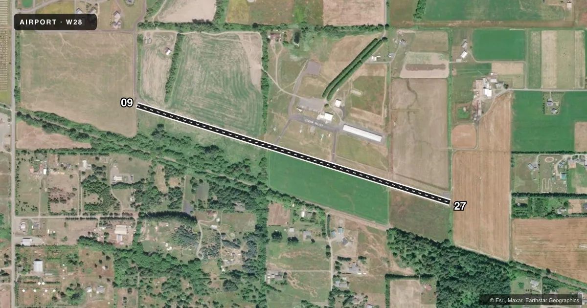
Runways & pattern
Full pagePattern entry · RWY 09
RIGHT TRAFFICRunway end performance
| End | TORA | TODA | ASDA | LDA | VGSI | Approach lights | Obstruction |
|---|---|---|---|---|---|---|---|
| 09 | — | — | — | — | — | — | 90', trees, 1243' from thr, 0' R of cntrln, slope 11 |
| 27 | — | — | — | — | — | — | 65', trees, 686' from thr, 25' R of cntrln, slope 7 |
Declared distances in feet. TORA = takeoff run available, TODA = takeoff distance, ASDA = accelerate-stop, LDA = landing distance.
Airport sketch
Runways drawn to scale from FAA survey coordinates, rendered over satellite imagery. Not for navigation.
Approaches & charts
Services on the field
Fuel grades, oxygen, maintenance, ramp storage and lighting — as declared to the FAA by the airport operator.
Fuel & services
- Fuel
- 100LL
- Oxygen (bottled)
- Not available
- Oxygen (bulk)
- Not available
- Airframe repair
- Not available
- Power plant repair
- Not available
- Other services
- CHTR
Ramp & ground
- Transient storage
- Tie-down
- Landing fee
- Yes
- Lighting schedule
- SS-SR
- Beacon schedule
- SS-SR
- Beacon
- White / Green (civil land)(WG)
- Wind indicator
- Yes
Fuel & FBOs
Cheapest 100LL and Jet A on the field and nearby. Always confirm with the FBO before taxi.
Airport notes
Surface conditions, obstructions, local procedures, lighting outages and other notes published with each FAA cycle.
General notes
- WILDLIFE ON & INVOF ARPT.
- FOR CD CTC WHIDBEY APCH AT 360-257-3310.
Fuel notes
- 100LLSELF SVC FUEL AVBL 24 HRS.
Runway surface & condition
- 09/27HAS 2 INCH SHOULDER DROPOFF.
Approach & departure obstructions
- 09RWY 09 2 FT SIGN, 37 FT L AND 3 FT SIGN, 45 FT L OF CNTRLN 4 FT FM RWY END.
- 27RWY 27 FENCE POST 4.5 FT HIGH, 38 FT LEFT RWY CNTRLN. RWY 27 IRRIGATION PIPE PARL ONE THIRD OF RWY; 2 FT SIGN AT 36 FT RIGHT OF CNTRLN.
Other notes
- INSTALL SEGMENTED CIRCLE; POST RY END SIGNS FOR DEPARTURE PATTERNS; INSTALL UNICOM;
- GPS MONUMENT LOCATED AT WINDSOCK.
- OWNEREMAIL ADDRESS: SEQUIMAIRPORT@GMAIL.COM
VFR map & nearby airports
VFR sectional. Tap any ICAO chip to open that airport.
Key facts · W28
Answer card- ICAO
- W28
- Name
- SEQUIM VALLEY
- Location
- SEQUIM, WASHINGTON
- Elevation
- 151 ft MSL
- Traffic pattern altitude
- 1,151 ft MSL (1,000 AGL)
- Control tower
- Non-towered (use CTAF)
- Total runways
- 1
- Longest runway
- 09/27 · 3,508 ft
- Published ILS approaches
- 0
- Published frequencies
- 2
- Magnetic variation
- 21°
- Current flight rules
- VFR
- Current wind
- 000° at 0 kt
- Favored runway now
- –
Sequim Valley Airport sits in Sequim, Washington at 151 ft MSL. It has one asphalt runway, 09/27, which is 3,508 ft long. There is no control tower. CTAF and UNICOM are both 122.7. No ILS approaches are published here.
The published pattern altitude is not listed, so use the standard 1,000 ft AGL unless the current Chart Supplement says otherwise. That puts the light aircraft pattern at 1,151 ft MSL based on the field elevation. The airport is served by Sequim Valley Airport on the field. It carries 100LL. Self-serve 100LL is available 24 hours. For clearance delivery, Whidbey Approach is listed in the remarks at 360-257-3310.
A few field notes matter here. Wildlife is reported on and near the airport. Runway 09/27 has a 2-inch shoulder dropoff. There are also obstructions near both runway ends, including signs near 09 and a fence post plus other items near 27. A segmented circle is installed. Runway end signs are posted for departure patterns. The GPS monument is at the windsock. If you are planning a first stop here, brief the runway edges carefully and expect a non-towered pattern with local traffic on 122.7.