METAR & TAF KCLM
Current METAR
Observed 13:33Z
KCLM 271333Z AUTO 00000KT 10SM BKN014 OVC110 13/13 A3004 RMK AO2 T01330128
- Wind
- 000° @ 0 kt
- Visibility
- 10 SM
- Temp / Dew
- 13°C / 13°C
- Altimeter
- 30.04 inHg
- Clouds
- OVC
- Density alt
- -28 ft
- Ceiling
- 1,400 ft AGL
- Rules
- MVFR
Airport info & contacts
Manager on record, flight service, ARTCC, attendance schedule and pattern altitude — published by the FAA and refreshed every 28 days.
Location
- From city
- 3 NM NW
- VFR sectional
- SEATTLE
- ARTCC
- ZSE · SEATTLE
- NOTAM facility
- CLM (NOTAM-D)
Airport manager
- Name
- JAMES ALTON
- Phone
- 360-417-3437
- Address
- 338 WEST FIRST STREET, PO BOX 1350, PORT ANGELES WA 98362
Flight service · Hours
- FSS SEA
- SEATTLE1-800-WX-BRIEF
- Attendance
- 0900-1930
Frequencies
Tap any row to copy the frequency to your clipboard.
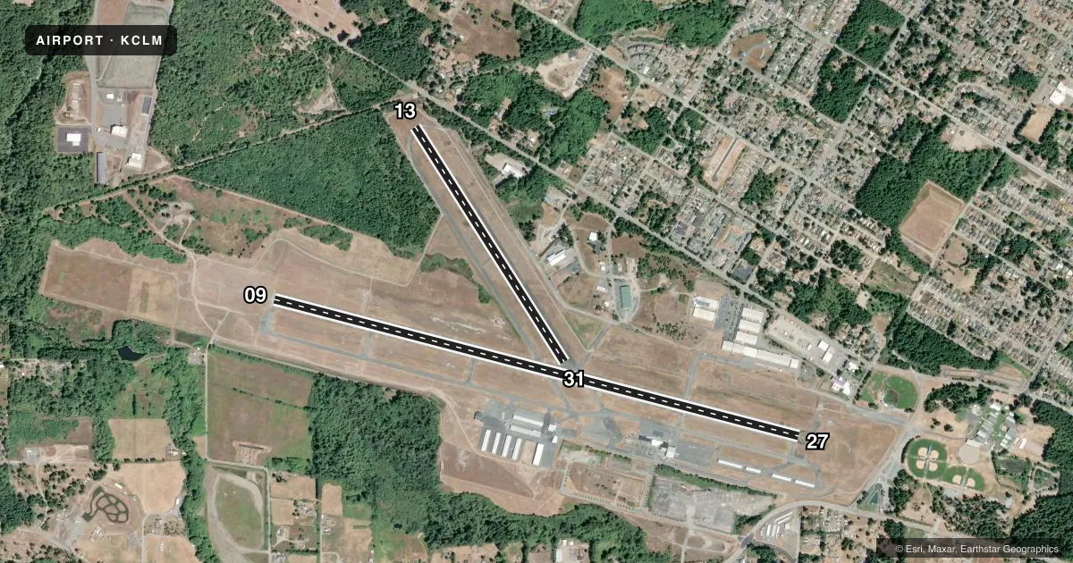
Runways & pattern
Full pagePattern entry · RWY 09
LEFT TRAFFIC| Runway | Heading (°M) | Length | Surface | Traffic |
|---|---|---|---|---|
| 09/27 | 89° / 269° | 6,347 ft | ASPH | 27 R |
| 13/31 | 132° / 312° | 3,255 ft | ASPH | 31 R |
Runway end performance
| End | TORA | TODA | ASDA | LDA | VGSI | Approach lights | Obstruction |
|---|---|---|---|---|---|---|---|
| 09 | — | — | — | — | PAPI 4-box left(3°) | MALSR | 111', trees, 3200' from thr, 0' R of cntrln, slope 27 |
| 27 | — | — | — | — | PAPI 4-box left(3.7°) | — | 19', ant, 300' from thr, 300' R of cntrln, slope 15 |
| 13 | — | — | — | — | — | — | 27', trees, 522' from thr, 0' R of cntrln, slope 11 |
| 31 | — | — | — | — | — | — | 37', trees, 1080' from thr, 0' R of cntrln, slope 23 |
Declared distances in feet. TORA = takeoff run available, TODA = takeoff distance, ASDA = accelerate-stop, LDA = landing distance.
Airport sketch
Runways drawn to scale from FAA survey coordinates, rendered over satellite imagery. Not for navigation.
Approaches & charts
ILS · 1
Services on the field
Fuel grades, oxygen, maintenance, ramp storage and lighting — as declared to the FAA by the airport operator.
Fuel & services
- Fuel
- 100LLA
- Airframe repair
- Major
- Power plant repair
- Major
- Other services
- AFRT,AMB,CARGO,CHTR,INSTR,RNTL
Ramp & ground
- Transient storage
- Tie-down
- Landing fee
- Yes
- Customs
- Not available
- Lighting schedule
- SEE RMK
- Beacon schedule
- SS-SR
- Beacon
- White / Green (civil land)(WG)
- Wind indicator
- Lighted
- Segmented circle
- Yes
Fuel & FBOs
Cheapest 100LL and Jet A on the field and nearby. Always confirm with the FBO before taxi.
Airport notes
Surface conditions, obstructions, local procedures, lighting outages and other notes published with each FAA cycle.
General notes
- RWY 13/31 CLSD DUSK TO DAWN.
- FOR CD IF UNA TO CTC ON FSS FREQ, CTC WHIDBEY APCH AT 360-257-3310.
Lighting notes
- ACTVT MALSR RWY 09; MIRL RWY 09/27 - CTAF.
Fuel notes
- 100LLFOR AFT HRS JET A CALL 360-452-6226.
Approach & departure obstructions
- 09UNUSBL BYD 5.0 NM DUE TO HIGH TERRAIN
- 27UNUSBL BYD 8 DEGS L OF CNTRLN.
- 27+35' BLDG; DIST 520'; 500' LEFT; 15:1 BASED ON DSPLCD THR.
Other notes
- LDG FEE FOR ACFT IN EXCESS OF 7000 LBS.
VFR map & nearby airports
VFR sectional. Tap any ICAO chip to open that airport.
Key facts · KCLM
Answer card- ICAO
- KCLM
- Name
- WILLIAM R FAIRCHILD INTL
- Location
- PORT ANGELES, WASHINGTON
- Elevation
- 291.3 ft MSL
- Traffic pattern altitude
- 1,291.3 ft MSL (1,000 AGL)
- Control tower
- Non-towered (use CTAF)
- Total runways
- 2
- Longest runway
- 09/27 · 6,347 ft
- Published ILS approaches
- 1
- Published frequencies
- 5
- Magnetic variation
- 16°
- Current flight rules
- MVFR
- Current wind
- 000° at 0 kt
- Favored runway now
- –
William R Fairchild Intl is in Port Angeles, Washington. The field elevation is 291.3 ft MSL. It has two asphalt runways. The longest is 09/27 at 6,347 ft. Runway 13/31 is 3,255 ft. There is no control tower, so plan on CTAF self-announce work. The published pattern altitude is not listed. Use standard 1,000 ft AGL unless the current Chart Supplement says otherwise. That puts the light piston pattern at 1,291.3 ft MSL.
KCLM has one ILS approach to runway 09. The airport uses CTAF 122.975 for both CTAF and UNICOM. Whidbey Approach is listed on 118.2 and 285.65. Clearance delivery is 124.15. Citizen Air, formerly Rite Bros. Aviation, is on the field. It carries 100LL, Jet A and Jet A Prist. For Jet A after hours, the published remarks say to call the FBO.
A few runway notes matter here. Visual glide slope indicators on runway 09 are unusable beyond 5 NM because of high terrain. Runway 27 has a building near the approach side, so pay attention to the displaced threshold and obstacle picture. Runway 13/31 is closed from dusk to dawn. If you are new to the field, brief the terrain, the non-towered pattern and the lighting setup before arrival.