METAR & TAF 8W5
8W5 does not publish a METAR.
Showing the nearest reporting station: KPWT (BREMERTON NTL) · 10.1 NM away. Conditions at 8W5 may differ.
METAR · KPWT
Observed 13:34Z
KPWT 271334Z AUTO 19007KT 10SM SCT010 14/14 A3007 RMK AO2
- Wind
- 190° @ 7 kt
- Visibility
- 10 SM
- Temp / Dew
- 14°C / 14°C
- Altimeter
- 30.07 inHg
- Clouds
- SCT
- Density alt
- 345 ft
- Ceiling
- Unlimited
- Rules
- VFR
Airport info & contacts
Manager on record, flight service, ARTCC, attendance schedule and pattern altitude — published by the FAA and refreshed every 28 days.
Location
- From city
- 2 NM NW
- VFR sectional
- SEATTLE
- ARTCC
- ZSE · SEATTLE
- NOTAM facility
- SEA (NOTAM-D)
Airport manager
- Name
- PAUL SCHNEIDER
- Phone
- 816-810-3327
- Address
- PO BOX 1659, APEX PROPERTY OWNERS, PRESIDENT, SILVERDALE WA 98383
Flight service · Hours
- FSS SEA
- SEATTLE1-800-WX-BRIEF
- Attendance
- 1000-1900
Frequencies
Tap any row to copy the frequency to your clipboard.
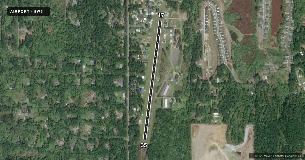
Runways & pattern
Full pagePattern entry · RWY 17
LEFT TRAFFICRunway end performance
| End | TORA | TODA | ASDA | LDA | VGSI | Approach lights | Obstruction |
|---|---|---|---|---|---|---|---|
| 17 | — | — | — | — | — | — | 65', trees, 844' from thr, 0' R of cntrln, slope 9 |
| 35 | — | — | — | — | — | — | 68', trees, 1035' from thr, 0' R of cntrln, slope 12 |
Declared distances in feet. TORA = takeoff run available, TODA = takeoff distance, ASDA = accelerate-stop, LDA = landing distance.
Airport sketch
Runways drawn to scale from FAA survey coordinates, rendered over satellite imagery. Not for navigation.
Approaches & charts
Services on the field
Fuel grades, oxygen, maintenance, ramp storage and lighting — as declared to the FAA by the airport operator.
Fuel & services
- Fuel
- Not available
- Oxygen (bottled)
- Not available
- Oxygen (bulk)
- Not available
- Airframe repair
- Major
- Power plant repair
- Major
Ramp & ground
- Transient storage
- Tie-down
- Landing fee
- No fee published
- Customs
- Not available
- Lighting schedule
- SS-SR
- Beacon schedule
- SS-SR
- Beacon
- White / Green (civil land)(WG)
- Wind indicator
- Yes
- Segmented circle
- Yes
Fuel & FBOs
Cheapest 100LL and Jet A on the field and nearby. Always confirm with the FBO before taxi.
Airport notes
Surface conditions, obstructions, local procedures, lighting outages and other notes published with each FAA cycle.
General notes
- TWY EAST SIDE RWY.
- NO LN OF SIGHT BTN RWY ENDS. TAX TO MID-FIELD RUN-UP AREA RQRD PRIOR TO TKOF TO CLR FOR OPDT.
- TREES, ACFT AND BDLGS IN TRANSITION SFCS.
- CHILDREN AND PETS ETC. INVOF ARPT.
- BE ALERT ON TWY.
- FOR CD CTC SEATTLE APCH AT 206-214-4722.
- ALL TFC PATS EAST OF FLD.
- CALM WIND RWY IS RWY 35.
- USE CTN FOR ACFT OPRG ON GRASS WEST OF RWY.
- INT TKOF PROHIBITED.
- TSNT PRKG BYD NORTH END RWY 35.
- USE MID-FIELD RUN-UP PAD FOR ALL RUN-UPS.
- CLIMB TO 1000 FT PRIOR TO TURNING FOR NOISE ABATEMENT.
Approach & departure obstructions
- 17+3 FT FENCE, 26 FT RIGHT AT 60 FT; +60 FT TREES, 65 FT RIGHT AT 150 FT; 15 FT BRUSH, 67 FT LEFT AT 75 FT; BLDG AT 55 FT, 80 FT LEFT; 17 FT BLDG AT 77 FT, 72 FT RIGHT.
- 35+4 FT SIGN 66 FT RIGHT AT 45 FT, +10 FT TO +70 FT BRUSH AND TREES 85-125 FT LEFT FM THR TO 200 FT. BRUSH AND TREES 105 FT RIGHT AT 174 FT FM THR.
- 17ARPT NAME & SEGEMENTED CIRCLE PAINTED ON RWY AT MIDFIELD.
Other notes
- MANAGERH2OAV8R@GMAIL.COM
- OWNERALT MGR BILL ROARK AT 206-390-4131.
VFR map & nearby airports
VFR sectional. Tap any ICAO chip to open that airport.
Key facts · 8W5
Answer card- ICAO
- 8W5
- Name
- APEX AIRPARK
- Location
- SILVERDALE, WASHINGTON
- Elevation
- 525 ft MSL
- Traffic pattern altitude
- 1,525 ft MSL (1,000 AGL)
- Control tower
- Non-towered (use CTAF)
- Total runways
- 1
- Longest runway
- 17/35 · 2,491 ft
- Published ILS approaches
- 0
- Published frequencies
- 2
- Magnetic variation
- 21°
- Current flight rules
- VFR
- Current wind
- 190° at 7 kt
- Favored runway now
- RWY 17
APEX AIRPARK is in Silverdale, Washington. Field elevation is 525 ft MSL. The airport has one runway. Runway 17/35 is 2,491 ft long and paved asphalt. There is no control tower. CTAF and UNICOM are both 122.8.
No ILS approaches are published here. Pattern altitude is not published, so use the standard 1,000 ft AGL for light piston operations unless the current Chart Supplement says otherwise. The airport sits in a busy local operating environment. The remarks call out no line of sight between runway ends. Plan on taxiing to the midfield run-up area before takeoff. The midfield run-up pad is also the place to use for run-ups. Trees, buildings and other aircraft are noted in the transition surfaces. There are also obstructions near both runway ends. Use extra caution on the taxiway. The runway has the airport name and segmented circle painted at midfield. The taxiway is on the east side of the runway. Grass operations west of the runway are also mentioned in the remarks. Keep a sharp scan for traffic and people on the field.
There are no on-field FBOs listed in the facts. If you need current services, contact the airport operator directly or call the field on CTAF or UNICOM before arrival. For clearance delivery, Seattle Approach is listed in the remarks at 206-214-4722.