METAR & TAF KSEA
Current METAR
Observed 05:53Z
KSEA 280553Z 24005KT 10SM FEW050 BKN095 20/13 A3001 RMK AO2 SLP167 T02000128 10261 20194 50000 $
- Wind
- 240° @ 5 kt
- Visibility
- 10 SM
- Temp / Dew
- 20°C / 13°C
- Altimeter
- 30.01 inHg
- Clouds
- BKN
- Density alt
- 1,024 ft
- Ceiling
- 9,500 ft AGL
- Rules
- VFR
Airport info & contacts
Manager on record, flight service, ARTCC, attendance schedule and pattern altitude — published by the FAA and refreshed every 28 days.
Location
- From city
- 10 NM S
- VFR sectional
- SEATTLE
- ARTCC
- ZSE · SEATTLE
- NOTAM facility
- SEA (NOTAM-D)
Airport manager
- Name
- WENDY REITER
- Phone
- (206) 787-5229
- Address
- BOX 68727, SEATTLE WA 98168
Flight service · Hours
- FSS SEA
- SEATTLE1-800-WX-BRIEF
- Attendance
- ALL
Frequencies
Tap any row to copy the frequency to your clipboard.
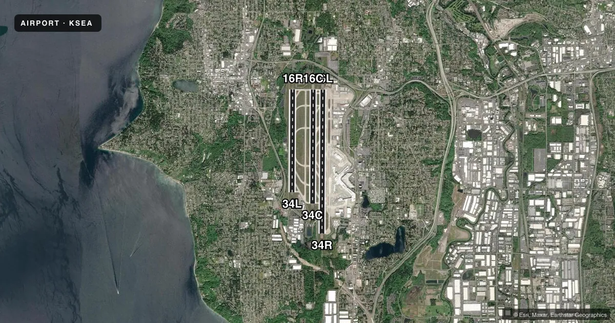
Runways & pattern
Full pagePattern entry · RWY 16L
LEFT TRAFFIC| Runway | Heading (°M) | Length | Surface | Traffic |
|---|---|---|---|---|
| 16L/34RFavored | 164° / 344° | 11,901 ft | CONC | Standard L |
| 16C/34C | 164° / 344° | 9,426 ft | CONC | Standard L |
| 16R/34L | 164° / 344° | 8,500 ft | CONC | Standard L |
Runway end performance
| End | TORA | TODA | ASDA | LDA | VGSI | Approach lights | Obstruction |
|---|---|---|---|---|---|---|---|
| 16L | 11,901' | 11,901' | 11,901' | 11,901' | PAPI 4-box left(3°) | ALSF2 | — |
| 34R | 11,901' | 11,901' | 11,901' | 11,901' | PAPI 4-box left(2.75°) | MALSR | — |
| 16C | 9,426' | 9,426' | 9,426' | 9,426' | PAPI 4-box left(3°) | ALSF2 | — |
| 34C | 9,426' | 9,426' | 9,426' | 9,426' | PAPI 4-box left(3°) | MALSR | — |
| 16R | 8,500' | 8,500' | 8,500' | 8,500' | PAPI 4-box right(3°) | ALSF2 | — |
| 34L | 8,500' | 8,500' | 8,500' | 8,500' | PAPI 4-box left(3°) | MALSR | — |
Declared distances in feet. TORA = takeoff run available, TODA = takeoff distance, ASDA = accelerate-stop, LDA = landing distance.
Airport sketch
Runways drawn to scale from FAA survey coordinates, rendered over satellite imagery. Not for navigation.
Approaches & charts
ILS · 6
Services on the field
Fuel grades, oxygen, maintenance, ramp storage and lighting — as declared to the FAA by the airport operator.
Fuel & services
- Fuel
- AA1
- Oxygen (bottled)
- Not available
- Oxygen (bulk)
- Not available
- Airframe repair
- Not available
- Power plant repair
- Not available
- Other services
- AFRT,CARGO,CHTR
Ramp & ground
- Transient storage
- Tie-down
- Landing fee
- Yes
- Customs
- Not available
- Lighting schedule
- SS-SR
- Beacon schedule
- SS-SR
- Beacon
- White / Green (civil land)(WG)
- Wind indicator
- Lighted
- Segmented circle
- No
Fuel & FBOs
Cheapest 100LL and Jet A on the field and nearby. Always confirm with the FBO before taxi.
Airport notes
Surface conditions, obstructions, local procedures, lighting outages and other notes published with each FAA cycle.
General notes
- BIRD FLOCKS ON AND INVOF ARPT - CHECK LCL ADZYS.
- FLIGHT NOTIFICATION SERVICE (ADCUS) AVBL.
- HELICOPTERS LANDING & DEPARTING AVOID OVERFLYING FUEL FARM LCTD AT THE SE CORNER OF THE ARPT.
- (E110) CONTINUOUS POWER ARPT.
- (E94) WSO/WSFO.
- TWY A SOUTH OF TWY G RSTD TO ACFT WITH WINGSPAN 225 FT OR LESS.
- DO NOT MISTAKE TWY T FOR LDG SFC.
- ACES TO AIR CARGO 4 PRKG AND CARGO AREAS RSTD TO ACFT WITH WINGSPAN 170 FT OR LESS.
- TWY FOR CORPORATE HNGR RAMP RSTD TO ACFT WITH WINGSPAN 62 FT OR LESS FOR TAXI OPS. GA CUST PRKG IS VERY LTD.
- PPR FOR ALL GA PRKG AND SVCS;, CTC 206-433-5481. OPER HRS 0700L - 2100L, WITH A CALL OUT AVBL UPON REQ.
- TXL W RSTRD TO ACFT WITH WINGSPAN 135 FT OR LESS NORTH OF TWY N AND 167 FT OR LESS SOUTH OF TWY N. SEATTLE RAMP TWR PRVDS ADZY CTL ONLY.
- GA LDG FEES PAYABLE BY MAJOR CREDIT CARDS ONLY.
- TXL ON NORTH SIDE OF TWY N STLT RSTD TO ACFT WITH WINGSPAN 118 FT OR LESS. TRI-TXL'S AT NORTH STLT: CNTR (GREEN) TXL RSTD TO ACFT WITH WINGSPAN 135 FT OR LESS. WHEN AN ACFT IS ON THE CNTR (GREEN) OR OTR (ORANGE/BLUE) TXL'S, NO OTR ACFT CAN SIMUL USE THE ADJ TXL(S). ORANGE & BLUE TXL'S ARE RSTD TO ACFT WITH WINGSPAN 118 FT OR LESS. TWO ACFT CAN SIMUL USE THE OUTER TXL'S.
- RY STATUS LGTS ARE IN OPN.
- ACFT WITH WINGSPAN OF 171 FT. OR MORE PRKD AT PAX GATES OR CARGO 7 MUST PROVD 30 MIN PPR PRIOR TO PUSHBACK TO SEATTLE RAMP TWR WHEN VIS LESS THAN 2400 RVR.
- TWY J EAST OF TWY T RSTD TO ACFT WITH WINGSPAN 118 FT OR LESS.
- RWY 16L/34R RSTD TO ACFT WITH WINGSPAN 260 FT OR LESS.
- TWY H RSTRD TO ACFT WITH WINGSPAN 118 FT OR LESS.
- TWY B SOUTH OF TWY S RSTRD TO ACFT WITH WINGSPAN 260 FT OR LESS.
- AIR CARGO 5 RAMP DUAL ENG TAX ONLY
- 100LL FUEL NOT AVBL.
- THE USE OF REVERSE THRUST BYD WHAT IS NEC FOR OPNL OR SAFETY RSNS IS DISCOURAGED AT ALL TIMES. NOISE ABATEMENT FLT PROCS IN EFCT BTN 2200-0600. FOR FURTHER INFO CTC SEA NOISE ABATEMENT OFC AT 206-787-5393.
- CONS TAXI TO TAKEOFF AT SEA. WHEN PRACTICAL, SAFE AND AVBL, CONS TAXI TO TAKEOFFS ARE ENCOURAGED. CONS TAXI TO TAKEOFFS MAY RDC ACFT NOISE WI NEARBY COMMUNITIES.
- RPRT BIRD STRIKES TO 206-787-7233
- SOUTH SATELLITE TXL RSTRD TO ACFT WITH WINGSPAN OF 214 FT OR LESS.
- CARGO1 RSTRD TO ACFT WITH WINGSPAN OF 170 FT OR LESS.
- TO MINIMIZE NOISE, FUEL BURN AND JET BLAST, OPERATORS ARE ADVISED TO USE THE MNM RQRD THRUST WHEN TAXIING INVOF THE TRML OR ACFT PRKG AREAS.
Runway surface & condition
- 16R/34LTDT 817
- 16C/34CPCR VALUE: 1002/R/B/W/T
- 16L/34RPCR VALUE: 1147/R/B/W/T
- 16R/34LPCR VALUE: 866/R/B/W/T
Other notes
- EXISTED PRIOR TO MAY 15, 1959.
VFR map & nearby airports
VFR sectional. Tap any ICAO chip to open that airport.
Key facts · KSEA
Answer card- ICAO
- KSEA
- Name
- SEATTLE-TACOMA INTL
- Location
- SEATTLE, WASHINGTON
- Elevation
- 432.3 ft MSL
- Traffic pattern altitude
- 1,432.3 ft MSL (1,000 AGL)
- Control tower
- Towered · 24
- Total runways
- 3
- Longest runway
- 16L/34R · 11,901 ft
- Published ILS approaches
- 6
- Published frequencies
- 57
- Magnetic variation
- 16°
- Current flight rules
- VFR
- Current wind
- 240° at 5 kt
- Favored runway now
- RWY 16L
Seattle-Tacoma Intl is in Seattle, Washington. Field elevation is 432.3 ft MSL. The airport has 3 concrete runways. The longest is 11,901 ft on 16L/34R. The tower is open 24 hours. Six ILS approaches are published for the runway ends. Pattern altitude is not published. Use 1,000 ft AGL for light piston traffic unless ATC assigns something different.
Signature Aviation is on the field. It carries JET_A and JET_A_PRIST. Call (206) 433-5481 before arrival. The airport is a continuous power airport. Prior permission is required for all general aviation parking and services. Operating hours are 0700 local to 2100 local. A call out is available on request.
This is a busy Class B field in a major metro area. Expect heavy airline and cargo traffic. Taxi routes can be tight for larger aircraft. Some north side taxiways have wingspan limits. The north satellite also has restrictions on which taxiways can be used at the same time. Helicopters should avoid overflying the fuel farm at the southeast corner. For runway planning, remember the magnetic variation is 16°. If you need current taxi, parking, or access details, check the current FAA Chart Supplement or call the airport operator directly.