METAR & TAF KTIW
Current METAR
Observed 12:53Z
KTIW 271253Z AUTO 18005KT 10SM OVC110 14/12 A3007 RMK AO2 SLP182 T01390122
- Wind
- 180° @ 5 kt
- Visibility
- 10 SM
- Temp / Dew
- 14°C / 12°C
- Altimeter
- 30.07 inHg
- Clouds
- OVC
- Density alt
- 60 ft
- Ceiling
- 11,000 ft AGL
- Rules
- VFR
Airport info & contacts
Manager on record, flight service, ARTCC, attendance schedule and pattern altitude — published by the FAA and refreshed every 28 days.
Location
- From city
- 4 NM W
- VFR sectional
- SEATTLE
- Pattern altitude
- 1,000 ft AGL · 1,295 ft MSL
- ARTCC
- ZSE · SEATTLE
- NOTAM facility
- TIW (NOTAM-D)
Airport manager
- Name
- DENNIS SMITH
- Phone
- 253-798-8551
- Address
- 1202 - 26TH AVE. N.W., GIG HARBOR WA 98335-7322
Flight service · Hours
- FSS SEA
- SEATTLE1-800-WX-BRIEF
- Attendance
- 0700-1600
Frequencies
Tap any row to copy the frequency to your clipboard.
Runways & pattern
Full pagePattern entry · RWY 17
LEFT TRAFFICRunway end performance
| End | TORA | TODA | ASDA | LDA | VGSI | Approach lights | Obstruction |
|---|---|---|---|---|---|---|---|
| 17 | — | — | — | — | PAPI 4-box right(3°) | MALSR | — |
| 35 | — | — | — | — | PAPI 4-box left(3°) | — | — |
Declared distances in feet. TORA = takeoff run available, TODA = takeoff distance, ASDA = accelerate-stop, LDA = landing distance.
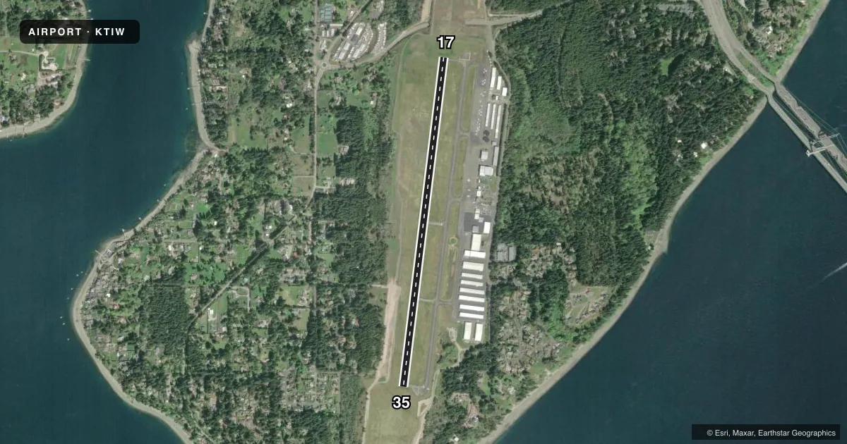
Airport sketch
Runways drawn to scale from FAA survey coordinates, rendered over satellite imagery. Not for navigation.
Approaches & charts
ILS · 1
Services on the field
Fuel grades, oxygen, maintenance, ramp storage and lighting — as declared to the FAA by the airport operator.
Fuel & services
- Fuel
- 100LLA
- Oxygen (bottled)
- Low pressure
- Airframe repair
- Major
- Power plant repair
- Major
- Other services
- AVNCS,CHTR,INSTR,RNTL,SALES
Ramp & ground
- Transient storage
- Tie-down
- Hangar
- Landing fee
- No fee published
- Customs
- Not available
- Lighting schedule
- SEE RMK
- Beacon schedule
- SS-SR
- Beacon
- White / Green (civil land)(WG)
- Wind indicator
- Lighted
- Segmented circle
- Yes
Fuel & FBOs
Cheapest 100LL and Jet A on the field and nearby. Always confirm with the FBO before taxi.
Airport notes
Surface conditions, obstructions, local procedures, lighting outages and other notes published with each FAA cycle.
General notes
- NOISE ABATEMENT PROC IN EFCT - AMGR.
- DEER ON & INVOF ARPT.
- LAWRS OPS DURG TWR HR.
- EMERG FREQ 121.5 NOT MNT AT ATCT.
- FOR CD WHEN ATCT IS CLSD CTC SEATTLE APCH AT 206-214-4723.
Lighting notes
- WHEN ATCT CLSD, ACTVT MALSR RWY 17; REIL RWY 35; PAPI RWY 17 & 35; MIRL 17/35 - CTAF.
Approach & departure obstructions
- 35PAPI UNUSBL BYD 5.0 DEGREES LEFT OF CNTRLN.
Other notes
- CUSTOMS - 253-593-6338 EXT #2.
- PILOTS BRING OWN TIEDOWNS.
VFR map & nearby airports
VFR sectional. Tap any ICAO chip to open that airport.
Key facts · KTIW
Answer card- ICAO
- KTIW
- Name
- TACOMA NARROWS
- Location
- TACOMA, WASHINGTON
- Elevation
- 294.8 ft MSL
- Traffic pattern altitude
- 1,294.8 ft MSL (1,000 AGL)
- Control tower
- Towered · 0800-2000
- Total runways
- 1
- Longest runway
- 17/35 · 5,002 ft
- Published ILS approaches
- 1
- Published frequencies
- 8
- Magnetic variation
- 20°
- Current flight rules
- VFR
- Current wind
- 180° at 5 kt
- Favored runway now
- RWY 17
Tacoma Narrows is in Tacoma, Washington. The field elevation is 294.8 ft MSL. It has one runway, 17/35, which is 5,002 ft long. The airport is towered from 0800 to 2000. When the tower is closed, use CTAF for lighting activation. The airport has one ILS approach to runway 17.
Pattern altitude is 1,294.8 ft MSL. That is 1,000 ft AGL. The field sits close to sea level for the region, so density altitude is usually not the main issue. Local traffic can still be busy. Noise abatement procedures are in effect as directed by the airport manager. Deer are on and near the airport, so keep an eye out on taxi and takeoff.
PAVCO Flight Center is on the field. It carries AVGAS 100LL, JET A and JET A Prist. The airport remarks also note that pilots must bring their own tiedowns. If you need customs, the published remarks list a contact number. If you are flying in after tower hours, check the current FAA Chart Supplement for the lighting and clearance details before departure.