METAR & TAF KPLU
Current METAR
Observed 03:35Z
KPLU 270335Z AUTO 00000KT 10SM -DZ FEW065 FEW075 OVC100 17/15 A3009 RMK AO2
- Wind
- 000° @ 0 kt
- Visibility
- 10 SM
- Temp / Dew
- 17°C / 15°C
- Altimeter
- 30.09 inHg
- Clouds
- OVC
- Density alt
- 696 ft
- Ceiling
- 10,000 ft AGL
- Rules
- VFR
Airport info & contacts
Manager on record, flight service, ARTCC, attendance schedule and pattern altitude — published by the FAA and refreshed every 28 days.
Location
- From city
- 5 NM S
- VFR sectional
- SEATTLE
- ARTCC
- ZSE · SEATTLE
- NOTAM facility
- PLU (NOTAM-D)
Airport manager
- Name
- DENNIS SMITH
- Phone
- 253-798-8551
- Address
- 16915 103RD AVE E, PUYALLUP WA 98374-3768
Flight service · Hours
- FSS SEA
- SEATTLE1-800-WX-BRIEF
- Attendance
- 0800-1400
Frequencies
Tap any row to copy the frequency to your clipboard.
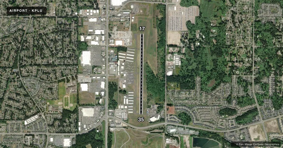
Runways & pattern
Full pagePattern entry · RWY 17
LEFT TRAFFICRunway end performance
| End | TORA | TODA | ASDA | LDA | VGSI | Approach lights | Obstruction |
|---|---|---|---|---|---|---|---|
| 17 | — | — | — | — | PAPI 4-box left(4°) | — | 75', trees, 2800' from thr, slope 34 |
| 35 | — | — | — | — | PAPI 4-box right(4°) | — | 13', road, 242' from thr, slope 3 |
Declared distances in feet. TORA = takeoff run available, TODA = takeoff distance, ASDA = accelerate-stop, LDA = landing distance.
Airport sketch
Runways drawn to scale from FAA survey coordinates, rendered over satellite imagery. Not for navigation.
Approaches & charts
Services on the field
Fuel grades, oxygen, maintenance, ramp storage and lighting — as declared to the FAA by the airport operator.
Fuel & services
- Fuel
- 100LL
- Oxygen (bottled)
- Low pressure
- Oxygen (bulk)
- Not available
- Airframe repair
- Major
- Power plant repair
- Major
- Other services
- AVNCS,INSTR,RNTL
Ramp & ground
- Transient storage
- Tie-down
- Landing fee
- No fee published
- Customs
- Not available
- Lighting schedule
- SEE RMK
- Beacon schedule
- SS-SR
- Beacon
- White / Green (civil land)(WG)
- Wind indicator
- Lighted
- Segmented circle
- Yes
Fuel & FBOs
Cheapest 100LL and Jet A on the field and nearby. Always confirm with the FBO before taxi.
Airport notes
Surface conditions, obstructions, local procedures, lighting outages and other notes published with each FAA cycle.
General notes
- ULTRALIGHTS PROHIBITED.
- NOISE SENSITIVE ALL QUADRANTS.
- FOR CD CTC SEATTLE APCH AT 206-214-4723.
Lighting notes
- ACTVT REIL RWYS 17 & 35; PAPI RWYS 17 & 35 AND MIRL RWY 17/35 -CTAF.
Fuel notes
- 100LLFUEL AVBL 24 HOURS WITH CREDIT CARD.
Other notes
- ESTABD PRIOR TO 15 MAY 1959.
- PILOTS BRING OWN TIE-DOWNS.
VFR map & nearby airports
VFR sectional. Tap any ICAO chip to open that airport.
Key facts · KPLU
Answer card- ICAO
- KPLU
- Name
- PIERCE COUNTY/THUN FLD
- Location
- PUYALLUP, WASHINGTON
- Elevation
- 537.6 ft MSL
- Traffic pattern altitude
- 1,537.6 ft MSL (1,000 AGL)
- Control tower
- Non-towered (use CTAF)
- Total runways
- 1
- Longest runway
- 17/35 · 3,651 ft
- Published ILS approaches
- 0
- Published frequencies
- 5
- Magnetic variation
- 15°
- Current flight rules
- VFR
- Current wind
- 000° at 0 kt
- Favored runway now
- –
Pierce County/Thun Fld sits in Puyallup, Washington at 537.6 ft MSL. It has one asphalt runway, 17/35, which is 3,651 ft long. There is no control tower. Pattern altitude is not published in the facts, so use the standard 1,000 ft AGL for light piston traffic unless the current FAA Chart Supplement says otherwise.
No ILS approaches are published here. The field is in the Seattle approach area, so expect to work with Seattle Approach for clearances and IFR handling. Clearance delivery is listed on the remarks. There is a phone number for Seattle Approach if you need it before departure. The airport is noise sensitive in all quadrants. Ultralights are prohibited.
Pierce County Airport is the on-field FBO. It carries 100LL. Fuel is available 24 hours with credit card. Pilots should bring their own tie-downs. Runway end identifier lights are available on 17 and 35. PAPI is available on both runway ends. Medium intensity runway lights are controlled by CTAF. For a first-time arrival, the main things to plan for are the noise sensitivity, the non-towered flow and the runway length. The field elevation is moderate, so performance planning still matters on warm days.