METAR & TAF 2W3
2W3 does not publish a METAR.
Showing the nearest reporting station: KPLU (PIERCE COUNTY/THUN FLD) · 14.0 NM away. Conditions at 2W3 may differ.
METAR · KPLU
Observed 05:55Z
KPLU 270555Z AUTO 00000KT 10SM -DZ BKN026 BKN048 OVC060 16/15 A3008 RMK AO2
- Wind
- 000° @ 0 kt
- Visibility
- 10 SM
- Temp / Dew
- 16°C / 15°C
- Altimeter
- 30.08 inHg
- Clouds
- OVC
- Density alt
- 967 ft
- Ceiling
- 2,600 ft AGL
- Rules
- MVFR
Airport info & contacts
Manager on record, flight service, ARTCC, attendance schedule and pattern altitude — published by the FAA and refreshed every 28 days.
Location
- From city
- 1 NM NE
- VFR sectional
- SEATTLE
- Pattern altitude
- 800 ft AGL · 1,643 ft MSL
- ARTCC
- ZSE · SEATTLE
- NOTAM facility
- SEA (NOTAM-D)
Airport manager
- Name
- DAVID IRELAND
- Phone
- 714-686-8480
- Address
- PO BOX 546, EATONVILLE WA 98328
Flight service · Hours
- FSS SEA
- SEATTLE1-800-WX-BRIEF
- Attendance
- 0800-2000
Frequencies
Tap any row to copy the frequency to your clipboard.
Runways & pattern
Full pagePattern entry · RWY 16
RIGHT TRAFFICRunway end performance
| End | TORA | TODA | ASDA | LDA | VGSI | Approach lights | Obstruction |
|---|---|---|---|---|---|---|---|
| 16 | — | — | — | — | — | — | 106', trees, 1045' from thr, 0' R of cntrln, slope 7 |
| 34 | — | — | — | — | — | — | 20', gnd, 450' from thr, 0' R of cntrln, slope 12 |
Declared distances in feet. TORA = takeoff run available, TODA = takeoff distance, ASDA = accelerate-stop, LDA = landing distance.
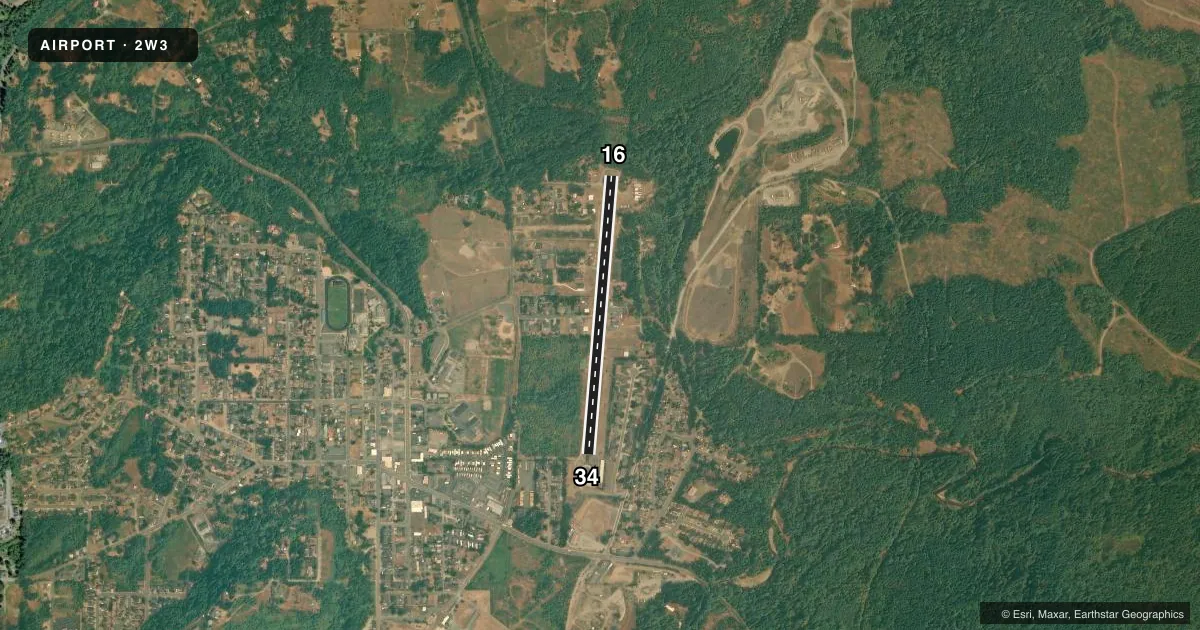
Airport sketch
Runways drawn to scale from FAA survey coordinates, rendered over satellite imagery. Not for navigation.
Approaches & charts
Services on the field
Fuel grades, oxygen, maintenance, ramp storage and lighting — as declared to the FAA by the airport operator.
Fuel & services
- Fuel
- Not available
- Oxygen (bottled)
- Not available
- Oxygen (bulk)
- Not available
- Airframe repair
- Major
- Power plant repair
- Major
Ramp & ground
- Transient storage
- Tie-down
- Hangar
- Landing fee
- No fee published
- Customs
- Not available
- Lighting schedule
- SEE RMK
- Wind indicator
- Lighted
- Segmented circle
- No
Fuel & FBOs
Cheapest 100LL and Jet A on the field and nearby. Always confirm with the FBO before taxi.
Airport notes
Surface conditions, obstructions, local procedures, lighting outages and other notes published with each FAA cycle.
General notes
- TREES IN APCH & TRANSITIONAL SFCS BOTH SIDES OF RWY.
- DEER ON AND IN VCNTY OF ARPT DUSK AND DAWN.
- BLDGS ARE IN CLOSE PROXIMITY TO RY.
- ANNC BACK TAXI ON RWY. GRVL SVC ROAD ARND RWY 16/34 NOT AVBL FOR ACFT OPS.
- FOR CD CTC SEATTLE APCH AT 206-214-4723.
- RESTROOMS AVBL AT TRINITY AVN ACADEMY NE END.
- BICYCLES AVBL AT N END KIOSK
Lighting notes
- DUSK-0000. AFTER 0000, ACTVT MIRL RY 16/34 - CTAF.
Approach & departure obstructions
- 16RWY 16 14 FT TO 70 FT TREES FM 60 FT TO 200 FT FM THR; SUNKEN ROAD 51 FT FM THR; ROAD 88 FT R; ROAD 79 FT L; 4 FT SIGNS 57 FT R.
- 34RWY 34 ROAD 102 FT LEFT; BRUSH 82 FT LEFT; ROAD 84 FT RIGHT; ROAD 104 FT LEFT, 69 FT FM THLD; CIRCULAR ROAD 40 FT FM THLD.
- 16APRT NAME PAINTED IN CENTER OF RY.
Other notes
- ESTABD PRIOR TO MAY 1959.
- NON STD PAT 16R.
VFR map & nearby airports
VFR sectional. Tap any ICAO chip to open that airport.
Key facts · 2W3
Answer card- ICAO
- 2W3
- Name
- SWANSON FLD
- Location
- EATONVILLE, WASHINGTON
- Elevation
- 843 ft MSL
- Traffic pattern altitude
- 1,643 ft MSL (800 AGL)
- Control tower
- Non-towered (use CTAF)
- Total runways
- 1
- Longest runway
- 16/34 · 2,990 ft
- Published ILS approaches
- 0
- Published frequencies
- 1
- Magnetic variation
- 20°
- Current flight rules
- MVFR
- Current wind
- 000° at 0 kt
- Favored runway now
- –
Swanson Fld sits in Eatonville, Washington at 843 ft MSL. It has one runway, 16/34, which is 2,990 ft long. The field is not towered. CTAF is 122.9. No ILS approaches are published here. Pattern altitude is 800 ft AGL, which is 1,643 ft MSL.
This is a field where obstacle awareness matters. The Chart Supplement notes roads, brush, trees and signs close to both runway ends. Trees are also in the approach and transitional surfaces on both sides of the runway. Buildings are close to the runway too. Back taxi on the runway is announced. The gravel service road around runway 16/34 is not available for aircraft operations.
Lighting is on from dusk to 0000. After 0000, the medium intensity runway lights for 16/34 are activated by CTAF. Deer are reported on and near the airport at dusk and dawn, so keep that in mind on arrival and departure. There are no on-field FBOs listed, so verify services with the airport operator or call the field directly before you go. Restrooms are available at Trinity Aviation Academy at the northeast end. For clearance delivery, contact Seattle Approach at 206-214-4723.