METAR & TAF 44T
44T does not publish a METAR.
Showing the nearest reporting station: KOLM (OLYMPIA RGNL) · 3.4 NM away. Conditions at 44T may differ.
METAR · KOLM
Observed 21:54Z
KOLM 262154Z 23005KT 10SM BKN047 OVC055 21/12 A3006 RMK AO2 SLP179 T02110117 $
- Wind
- 230° @ 5 kt
- Visibility
- 10 SM
- Temp / Dew
- 21°C / 12°C
- Altimeter
- 30.06 inHg
- Clouds
- OVC
- Density alt
- 811 ft
- Ceiling
- 4,700 ft AGL
- Rules
- VFR
Airport info & contacts
Manager on record, flight service, ARTCC, attendance schedule and pattern altitude — published by the FAA and refreshed every 28 days.
Location
- From city
- 5 NM SE
- VFR sectional
- SEATTLE
- ARTCC
- ZSE · SEATTLE
- NOTAM facility
- SEA (NOTAM-D)
Airport manager
- Name
- JUDSON KELLEY
- Phone
- 360-870-9645
- Address
- 4410 62ND AVENUE SE, OLYMPIA WA 98513-4906
Flight service · Hours
- FSS SEA
- SEATTLE1-800-WX-BRIEF
- Attendance
- Unattended
Frequencies
Tap any row to copy the frequency to your clipboard.
Runways & pattern
Full pagePattern entry · RWY 25
LEFT TRAFFICRunway end performance
| End | TORA | TODA | ASDA | LDA | VGSI | Approach lights | Obstruction |
|---|---|---|---|---|---|---|---|
| 07 | — | — | — | — | — | — | 60', trees, 705' from thr, 0' R of cntrln, slope 11 |
| 25 | — | — | — | — | — | — | 101', trees, 205' from thr, 1' R of cntrln, slope 0 |
Declared distances in feet. TORA = takeoff run available, TODA = takeoff distance, ASDA = accelerate-stop, LDA = landing distance.
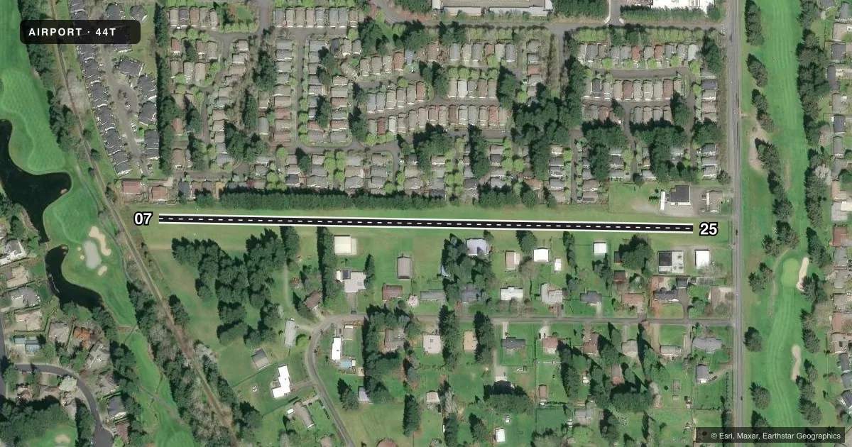
Airport sketch
Runways drawn to scale from FAA survey coordinates, rendered over satellite imagery. Not for navigation.
Approaches & charts
Services on the field
Fuel grades, oxygen, maintenance, ramp storage and lighting — as declared to the FAA by the airport operator.
Fuel & services
- Fuel
- Not available
- Airframe repair
- Not available
- Power plant repair
- Not available
Ramp & ground
- Transient storage
- Not published
- Landing fee
- No fee published
- Customs
- Not available
- Wind indicator
- Yes
- Segmented circle
- No
Fuel & FBOs
Cheapest 100LL and Jet A on the field and nearby. Always confirm with the FBO before taxi.
Airport notes
Surface conditions, obstructions, local procedures, lighting outages and other notes published with each FAA cycle.
General notes
- RCMD LAND RY 07, DEPART RY 25 WHEN WIND COND PERMITS.
- RY 07/25 NO LINE OF SIGHT BTN RY ENDS.
- NO HELS. NO ULTRALIGHTS. NOISE ABATEMENT PROC IN EFCT; CALL AMGR 360-870-9645. GEESE & DUCKS ON & INVOF ARPT.
- FOR CD CTC SEATTLE APCH AT 206-214-4723.
Other notes
- NON-COMPLIANCE WITH FAR 157.
VFR map & nearby airports
VFR sectional. Tap any ICAO chip to open that airport.
Key facts · 44T
Answer card- ICAO
- 44T
- Name
- HOSKINS FLD
- Location
- OLYMPIA, WASHINGTON
- Elevation
- 213 ft MSL
- Traffic pattern altitude
- 1,213 ft MSL (1,000 AGL)
- Control tower
- Non-towered (use CTAF)
- Total runways
- 1
- Longest runway
- 07/25 · 2,015 ft
- Published ILS approaches
- 0
- Published frequencies
- 1
- Magnetic variation
- 20°
- Current flight rules
- VFR
- Current wind
- 230° at 5 kt
- Favored runway now
- RWY 25
HOSKINS FLD is in Olympia, Washington. Field elevation is 213 ft MSL. It has one runway, 07/25, which is 2,015 ft of turf. The airport is not towered. CTAF is 122.9. No ILS approaches are published. The runway headings are 91° and 271° magnetic. Pattern altitude is not published in the facts. For light piston planning, use the standard 1,000 ft AGL pattern unless the current Chart Supplement says otherwise.
The published remarks matter here. Runway 07 is the recommended landing runway when wind allows. Runway 25 is the recommended departure runway when wind allows. Noise abatement procedures are in effect. No helicopters and no ultralights are allowed. The airport manager can be reached at 360-870-9645. Geese and ducks are reported on and near the field, so keep a sharp scan on short final and in the pattern. Runway 07/25 has no line of sight between runway ends, so do not assume the other end is clear. For clearance delivery, Seattle Approach is listed at 206-214-4723. Check the current FAA Chart Supplement for any published restrictions before flying in.