METAR & TAF KCLS
Current METAR
Observed 12:15Z
KCLS 271215Z AUTO 00000KT 10SM OVC110 14/14 A3009 RMK AO2
- Wind
- 000° @ 0 kt
- Visibility
- 10 SM
- Temp / Dew
- 14°C / 14°C
- Altimeter
- 30.09 inHg
- Clouds
- OVC
- Density alt
- -111 ft
- Ceiling
- 11,000 ft AGL
- Rules
- VFR
Airport info & contacts
Manager on record, flight service, ARTCC, attendance schedule and pattern altitude — published by the FAA and refreshed every 28 days.
Location
- From city
- 1 NM W
- VFR sectional
- SEATTLE
- ARTCC
- ZSE · SEATTLE
- NOTAM facility
- SEA (NOTAM-D)
Airport manager
- Name
- BRANDON RAKES
- Phone
- 360-748-1230
- Address
- 880 NW AIRPORT ROAD, CHEHALIS WA 98532
Flight service · Hours
- FSS SEA
- SEATTLE1-800-WX-BRIEF
- Attendance
- MON-FRI · 0700-1700
Frequencies
Tap any row to copy the frequency to your clipboard.
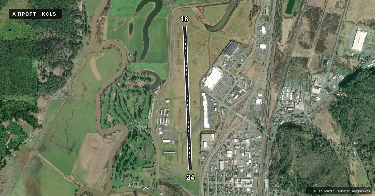
Runways & pattern
Full pagePattern entry · RWY 16
RIGHT TRAFFICRunway end performance
| End | TORA | TODA | ASDA | LDA | VGSI | Approach lights | Obstruction |
|---|---|---|---|---|---|---|---|
| 16 | — | — | — | — | PAPI 4-box left(3°) | — | — |
| 34 | — | — | — | — | VASI 2-box left(3.5°) | — | — |
Declared distances in feet. TORA = takeoff run available, TODA = takeoff distance, ASDA = accelerate-stop, LDA = landing distance.
Airport sketch
Runways drawn to scale from FAA survey coordinates, rendered over satellite imagery. Not for navigation.
Approaches & charts
Services on the field
Fuel grades, oxygen, maintenance, ramp storage and lighting — as declared to the FAA by the airport operator.
Fuel & services
- Fuel
- 100LLA
- Oxygen (bottled)
- Low pressure
- Oxygen (bulk)
- Not available
- Airframe repair
- Major
- Power plant repair
- Major
- Other services
- INSTR,RNTL
Ramp & ground
- Transient storage
- Tie-down
- Landing fee
- No fee published
- Customs
- Not available
- Lighting schedule
- SEE RMK
- Beacon schedule
- SS-SR
- Beacon
- White / Green (civil land)(WG)
- Wind indicator
- Lighted
- Segmented circle
- Yes
Fuel & FBOs
Cheapest 100LL and Jet A on the field and nearby. Always confirm with the FBO before taxi.
Airport notes
Surface conditions, obstructions, local procedures, lighting outages and other notes published with each FAA cycle.
General notes
- TFC PATTERN TO THE WEST ON ALL RY APCHS.
- POSSIBLE WILDLIFE ON RYS.
- WEEKEND GLIDER ACTIVITY IN SPRING, SUMMER AND EARLY FALL.
- FOR CD CTC SEATTLE ARTCC AT 253-351-3694.
Lighting notes
- ACTVT REIL RWY 16 & 34; PAPI RWY 16; MIRL RWY 16/34 - CTAF.
Fuel notes
- 100LLFUEL AVBL 24 HRS. BY CREDIT CARD ONLY. NO DEBIT CARDS.
Other notes
- ESTABD PRIOR TO 15 MAY 1959.
VFR map & nearby airports
VFR sectional. Tap any ICAO chip to open that airport.
Key facts · KCLS
Answer card- ICAO
- KCLS
- Name
- CHEHALIS-CENTRALIA
- Location
- CHEHALIS, WASHINGTON
- Elevation
- 177.2 ft MSL
- Traffic pattern altitude
- 1,177.2 ft MSL (1,000 AGL)
- Control tower
- Non-towered (use CTAF)
- Total runways
- 1
- Longest runway
- 16/34 · 5,000 ft
- Published ILS approaches
- 0
- Published frequencies
- 4
- Magnetic variation
- 16°
- Current flight rules
- VFR
- Current wind
- 000° at 0 kt
- Favored runway now
- –
Chehalis-Centralia Airport sits in Chehalis, Washington. Field elevation is 177.2 ft MSL. The airport has one runway, 16/34, at 5,000 ft. There is no control tower. Traffic uses CTAF 122.8. The published pattern is not listed in the facts, so assume the standard 1,000 ft AGL for light piston aircraft unless the current Chart Supplement says otherwise.
No ILS approaches are published here. Seattle approach is listed on 121.1 and 377.15 for radar services. The airport uses magnetic variation of 16°. The runway has medium intensity lights on the CTAF. Runway end identifier lights are installed on both ends. Runway 16 also has a PAPI. The published traffic pattern is to the west on all runway approaches. That matters here because the field also notes weekend glider activity in spring, summer and early fall. Wildlife on the runway is also a published concern.
The on-field FBO is Chehalis-Centralia Airport. It carries 100LL, Jet A and Jet A Prist. Fuel is available 24 hours by credit card only. Debit cards are not accepted. For clearance delivery, contact Seattle ARTCC at 253-351-3694 before departure if you need it.