METAR & TAF 4W0
4W0 does not publish a METAR.
Showing the nearest reporting station: KRNT (RENTON MUNI) · 28.2 NM away. Conditions at 4W0 may differ.
METAR · KRNT
Observed 10:53Z
KRNT 271053Z AUTO 14004KT 10SM BKN028 OVC034 17/13 A3007 RMK AO2 SLP186 T01670133
- Wind
- 140° @ 4 kt
- Visibility
- 10 SM
- Temp / Dew
- 17°C / 13°C
- Altimeter
- 30.07 inHg
- Clouds
- OVC
- Density alt
- 2,083 ft
- Ceiling
- 2,800 ft AGL
- Rules
- MVFR
Airport info & contacts
Manager on record, flight service, ARTCC, attendance schedule and pattern altitude — published by the FAA and refreshed every 28 days.
Location
- From city
- 0 NM W
- VFR sectional
- SEATTLE
- ARTCC
- ZSE · SEATTLE
- NOTAM facility
- SEA (NOTAM-D)
Airport manager
- Name
- JOHN WILSON
- Phone
- (360) 618-2477
- Address
- PO BOX 47312, OLYMPIA WA 98504-7264
Flight service · Hours
- FSS SEA
- SEATTLE1-800-WX-BRIEF
- Attendance
- Unattended
Frequencies
Tap any row to copy the frequency to your clipboard.
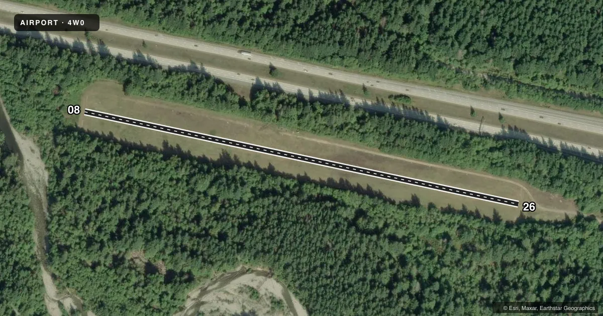
Runways & pattern
Full pagePattern entry · RWY 08
LEFT TRAFFICRunway end performance
| End | TORA | TODA | ASDA | LDA | VGSI | Approach lights | Obstruction |
|---|---|---|---|---|---|---|---|
| 08 | — | — | — | — | — | — | 36', trees, 164' from thr, 0' R of cntrln, slope 4 |
| 26 | — | — | — | — | — | — | 94', trees, 696' from thr, 0' R of cntrln, slope 7 |
Declared distances in feet. TORA = takeoff run available, TODA = takeoff distance, ASDA = accelerate-stop, LDA = landing distance.
Airport sketch
Runways drawn to scale from FAA survey coordinates, rendered over satellite imagery. Not for navigation.
Approaches & charts
Services on the field
Fuel grades, oxygen, maintenance, ramp storage and lighting — as declared to the FAA by the airport operator.
Fuel & services
- Fuel
- Not available
- Oxygen (bottled)
- Not available
- Oxygen (bulk)
- Not available
- Airframe repair
- Not available
- Power plant repair
- Not available
Ramp & ground
- Transient storage
- Tie-down
- Landing fee
- No fee published
- Customs
- Not available
- Wind indicator
- Yes
- Segmented circle
- No
Fuel & FBOs
Cheapest 100LL and Jet A on the field and nearby. Always confirm with the FBO before taxi.
Airport notes
Surface conditions, obstructions, local procedures, lighting outages and other notes published with each FAA cycle.
General notes
- ARPT CLSD 1 OCT - 1 JUN EXC FOR APPROVED MILITARY & PUBLIC SAFETY/LAW ENFORCEMENT HELICOPTER OPS.
- CTC WA STATE AVIATION DIVISION 360-709-8015 OR 1-800-552-0666 WA AREA FOR FACILITY INFO PRIOR TO USE.
- VEHICLES, PEDESTRIANS, & ANIMALS ON AND INVOF RY.
- RY MARKED WITH REFLECTORS DURING DATES ARPT IS OPEN.
- FOR ACFT ACCIDENTS/INCIDENTS CTC WA STATE EMERGENCY OPERATIONS CENTER 800-258-5990.
- CAMPING PERMITTED.
- FOR CD WHEN ATCT IS CLSD CTC SEATTLE APCH AT 206-214-4722.
Other notes
- ESTBD PRIOR TO MAY 1959.
- PILOTS BRING OWN ROPES.
- 08/26RY 26 WEST END EXTREMELY ROUGH; RY SOFT WHEN WET.
VFR map & nearby airports
VFR sectional. Tap any ICAO chip to open that airport.
Key facts · 4W0
Answer card- ICAO
- 4W0
- Name
- BANDERA STATE
- Location
- BANDERA, WASHINGTON
- Elevation
- 1,636 ft MSL
- Traffic pattern altitude
- 2,636 ft MSL (1,000 AGL)
- Control tower
- Non-towered (use CTAF)
- Total runways
- 1
- Longest runway
- 08/26 · 2,344 ft
- Published ILS approaches
- 0
- Published frequencies
- 1
- Magnetic variation
- 20°
- Current flight rules
- MVFR
- Current wind
- 140° at 4 kt
- Favored runway now
- RWY 08
Bandera State Airport sits in Bandera, Washington. Field elevation is 1,636 ft MSL. It has one runway. The longest is 08/26 at 2,344 ft on turf. No tower is published here. CTAF is 122.9. No ILS approaches are published.
The airport is closed from October 1 to June 1 except for approved military and public safety or law enforcement helicopter operations. That matters more than anything else for planning. When the tower is closed, clearance delivery goes through Seattle Approach at 206-214-4722. The runway is marked with reflectors during the dates the airport is open. Published remarks also say runway 26 west end is extremely rough. The runway can be soft when wet. Vehicles, pedestrians and animals may be on or near the runway.
Pattern altitude is not published. Use standard 1,000 ft AGL for light piston aircraft unless the current FAA Chart Supplement says otherwise. There are no on-field FBOs listed. Bring your own ropes if you plan to tie down. Pilots should also check the current FAA Chart Supplement and contact Washington State Aviation Division before use, since this field has special operating limits and seasonal closure rules.