METAR & TAF S93
S93 does not publish a METAR.
Showing the nearest reporting station: KELN (BOWERS FLD) · 17.4 NM away. Conditions at S93 may differ.
METAR · KELN
Observed 05:53Z
KELN 270553Z AUTO 31014KT 10SM FEW100 18/10 A3002 RMK AO2 PK WND 31028/0455 SLP156 T01780100 10283 20178 51017
- Wind
- 310° @ 14 kt
- Visibility
- 10 SM
- Temp / Dew
- 18°C / 10°C
- Altimeter
- 30.02 inHg
- Clouds
- FEW
- Density alt
- 2,647 ft
- Ceiling
- Unlimited
- Rules
- VFR
Airport info & contacts
Manager on record, flight service, ARTCC, attendance schedule and pattern altitude — published by the FAA and refreshed every 28 days.
Location
- From city
- 1 NM E
- VFR sectional
- SEATTLE
- ARTCC
- ZSE · SEATTLE
- NOTAM facility
- SEA (NOTAM-D)
Airport manager
- Name
- ROB OMANS
- Phone
- 509-674-2262
- Address
- 119 WEST 1ST STREET, CLE ELUM WA 98922
Flight service · Hours
- FSS SEA
- SEATTLE1-800-WX-BRIEF
- Attendance
- Unattended
Frequencies
Tap any row to copy the frequency to your clipboard.
Runways & pattern
Full pagePattern entry · RWY 25
LEFT TRAFFICRunway end performance
| End | TORA | TODA | ASDA | LDA | VGSI | Approach lights | Obstruction |
|---|---|---|---|---|---|---|---|
| 07 | — | — | — | — | PAPI 2-box left(4°) | — | — |
| 25 | — | — | — | — | PAPI 2-box left(4°) | — | — |
Declared distances in feet. TORA = takeoff run available, TODA = takeoff distance, ASDA = accelerate-stop, LDA = landing distance.
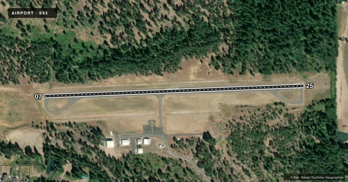
Airport sketch
Runways drawn to scale from FAA survey coordinates, rendered over satellite imagery. Not for navigation.
Approaches & charts
Services on the field
Fuel grades, oxygen, maintenance, ramp storage and lighting — as declared to the FAA by the airport operator.
Fuel & services
- Fuel
- Not available
- Oxygen (bottled)
- Not available
- Oxygen (bulk)
- Not available
- Airframe repair
- Not available
- Power plant repair
- Not available
Ramp & ground
- Transient storage
- Tie-down
- Landing fee
- No fee published
- Customs
- Not available
- Lighting schedule
- SEE RMK
- Beacon schedule
- SEE RMK
- Beacon
- White / Green (civil land)(WG)
- Wind indicator
- Lighted
Fuel & FBOs
Cheapest 100LL and Jet A on the field and nearby. Always confirm with the FBO before taxi.
Airport notes
Surface conditions, obstructions, local procedures, lighting outages and other notes published with each FAA cycle.
General notes
- TREES IN TRANSITION AREA.
- WILDLIFE ON & INVOF OF RUNWAY.
- FOR CD CTC SEATTLE ARTCC AT 253-351-3694.
- DITCH 75 FT FM CNTRLN RUNS LEN OF NORTHSIDE OF RWY.
Lighting notes
- ACTVT ROTG BCN - CTAF.
- ACTVT REIL RWY 07 & 25; MIRL RWY 07/25 - CTAF. PAPI RWY 07 & 25 OPER CONS.
Approach & departure obstructions
- 07MARKINGS ARE FADED.
- 25MARKINGS ARE FADED.
Other notes
- ESTABD PRIOR TO 15 MAY 1959.
- GLIDERS USE FREQ 122.3.
- TIE DOWNS PILOT PROVIDED
VFR map & nearby airports
VFR sectional. Tap any ICAO chip to open that airport.
Key facts · S93
Answer card- ICAO
- S93
- Name
- CLE ELUM MUNI
- Location
- CLE ELUM, WASHINGTON
- Elevation
- 1,944.7 ft MSL
- Traffic pattern altitude
- 2,944.7 ft MSL (1,000 AGL)
- Control tower
- Non-towered (use CTAF)
- Total runways
- 1
- Longest runway
- 07/25 · 2,379 ft
- Published ILS approaches
- 0
- Published frequencies
- 1
- Magnetic variation
- 20°
- Current flight rules
- VFR
- Current wind
- 310° at 14 kt
- Favored runway now
- RWY 25
Cle Elum Muni sits in Cle Elum, Washington. The field elevation is 1,944.7 ft MSL. It has one runway, 07/25, which is 2,379 ft long. There is no control tower. CTAF is 122.9.
No ILS approaches are published here. The pattern altitude is not published, so use the standard 1,000 ft AGL for light piston operations unless the current Chart Supplement says otherwise. The runway has medium intensity lights on CTAF. Runway end identifier lights are installed on 07 and 25. The rotating beacon is also on CTAF.
A few published remarks matter for planning. Markings on both runway ends are faded. Trees are in the transition area. Wildlife is on and near the runway. There is also a ditch about 75 feet from the north side of the runway that runs the length of the strip. Tie downs are pilot provided. Gliders use 122.3. For clearance delivery, contact Seattle ARTCC at 253-351-3694.
No on-field FBOs are listed in the facts. Check with the airport operator or call ahead for current services before you go. With the elevation and nearby terrain, expect a field that can feel busy in the pattern and less forgiving on climb performance than a lowland strip.