METAR & TAF 4S6
4S6 does not publish a METAR.
Showing the nearest reporting station: KYKM (YAKIMA AIR TRML/MCALLISTER FLD) · 24.3 NM away. Conditions at 4S6 may differ.
METAR · KYKM
Observed 15:53Z
KYKM 261553Z 00000KT 10SM CLR 19/09 A3003 RMK AO2 SLP164 T01890089 $
- Wind
- 000° @ 0 kt
- Visibility
- 10 SM
- Temp / Dew
- 19°C / 9°C
- Altimeter
- 30.03 inHg
- Clouds
- CLR
- Density alt
- 4,019 ft
- Ceiling
- Unlimited
- Rules
- VFR
Airport info & contacts
Manager on record, flight service, ARTCC, attendance schedule and pattern altitude — published by the FAA and refreshed every 28 days.
Location
- From city
- 2 NM S
- VFR sectional
- SEATTLE
- ARTCC
- ZSE · SEATTLE
- NOTAM facility
- SEA (NOTAM-D)
Airport manager
- Name
- JOHN WILSON
- Phone
- 360-618-2477
- Address
- PO BOX 47312, OLYMPIA WA 98504-7264
Flight service · Hours
- FSS SEA
- SEATTLE1-800-WX-BRIEF
- Attendance
- Unattended
Frequencies
Tap any row to copy the frequency to your clipboard.
Runways & pattern
Full pagePattern entry · RWY 02
LEFT TRAFFICRunway end performance
| End | TORA | TODA | ASDA | LDA | VGSI | Approach lights | Obstruction |
|---|---|---|---|---|---|---|---|
| 02 | — | — | — | — | — | — | 33', trees, 30' from thr, 74' R of cntrln, slope 1 |
| 20 | — | — | — | — | — | — | 199', trees, 894' from thr, 74' R of cntrln, slope 4 |
Declared distances in feet. TORA = takeoff run available, TODA = takeoff distance, ASDA = accelerate-stop, LDA = landing distance.
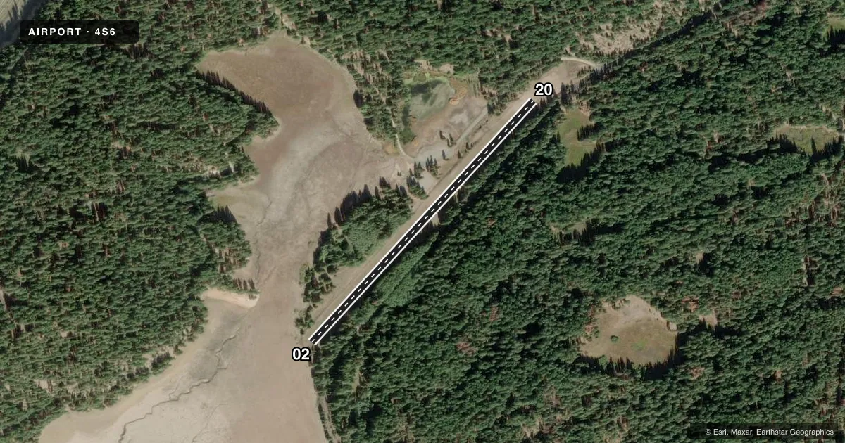
Airport sketch
Runways drawn to scale from FAA survey coordinates, rendered over satellite imagery. Not for navigation.
Approaches & charts
Services on the field
Fuel grades, oxygen, maintenance, ramp storage and lighting — as declared to the FAA by the airport operator.
Fuel & services
- Fuel
- Not available
- Oxygen (bottled)
- Not available
- Oxygen (bulk)
- Not available
- Airframe repair
- Not available
- Power plant repair
- Not available
Ramp & ground
- Transient storage
- Tie-down
- Landing fee
- No fee published
- Customs
- Not available
- Wind indicator
- Yes
- Segmented circle
- No
Fuel & FBOs
Cheapest 100LL and Jet A on the field and nearby. Always confirm with the FBO before taxi.
Airport notes
Surface conditions, obstructions, local procedures, lighting outages and other notes published with each FAA cycle.
General notes
- ARPT CLSD 1 OCT - 1 JUN EXC FOR APPROVED PUBLIC SAFETY/LAW ENFORCEMENT HELI OPS. BE ALERT, ARPT WINTER RECREATION ACTIVITIES DURING ARPT CLSD PERIODS. MIL, LOW APCH ONLY DURING CLSD PERIODS.
- VEHICLES, PEDESTRIANS, AND ANIMALS ON AND INVOF ARPT.
- GROUND RISES TO NORTHEAST.
- CTN: MOUNTAINOUS TRRN SURROUNDS ARPT.
Approach & departure obstructions
- 02TREES ARE ON TOP OF MOUNTAIN/HILL.
Other notes
- ESTABD PRIOR TO 15 MAY 1959.
- PILOTS PROVD TIEDOWN CHAINS.
- 02/20SFC GRASS & SMALL GRAVEL.
VFR map & nearby airports
VFR sectional. Tap any ICAO chip to open that airport.
Key facts · 4S6
Answer card- ICAO
- 4S6
- Name
- TIETON STATE
- Location
- RIMROCK, WASHINGTON
- Elevation
- 2,964 ft MSL
- Traffic pattern altitude
- 3,964 ft MSL (1,000 AGL)
- Control tower
- Non-towered (use CTAF)
- Total runways
- 1
- Longest runway
- 02/20 · 2,509 ft
- Published ILS approaches
- 0
- Published frequencies
- 1
- Magnetic variation
- 20°
- Current flight rules
- VFR
- Current wind
- 000° at 0 kt
- Favored runway now
- –
Tieton State Airport is in Rimrock, Washington. The field elevation is 2,964 ft MSL. It has one runway, 02/20, which is 2,509 ft long and surfaced with grass and small gravel. There is no control tower. CTAF is 122.9. No ILS approaches are published.
The published pattern altitude is not listed, so use the standard 1,000 ft AGL pattern unless the current Chart Supplement says otherwise. That puts the light piston pattern at about 3,964 ft MSL. The airport sits in mountainous terrain. The ground rises to the northeast. Trees are reported near runway 02 on the hill or mountain side. That makes the departure and arrival picture worth a careful look before you get there.
This field is closed from 1 October to 1 June except for approved public safety and law enforcement helicopter operations. During the closed period, expect airport winter recreation activity. Vehicles, pedestrians and animals may also be on or near the airport. Pilots should plan for a backcountry-style arrival and verify current status with the FAA Chart Supplement before going. There are no on-field FBOs listed. Contact the airport operator directly or call the field on CTAF for current service details. Pilots also provide their own tiedown chains.