METAR & TAF 2W1
2W1 does not publish a METAR.
Showing the nearest reporting station: KELN (BOWERS FLD) · 15.8 NM away. Conditions at 2W1 may differ.
METAR · KELN
Observed 13:53Z
KELN 261353Z AUTO 00000KT 10SM CLR 13/09 A3004 RMK AO2 SLP166 T01330089
- Wind
- 000° @ 0 kt
- Visibility
- 10 SM
- Temp / Dew
- 13°C / 9°C
- Altimeter
- 30.04 inHg
- Clouds
- CLR
- Density alt
- 1,843 ft
- Ceiling
- Unlimited
- Rules
- VFR
Airport info & contacts
Manager on record, flight service, ARTCC, attendance schedule and pattern altitude — published by the FAA and refreshed every 28 days.
Location
- From city
- 3 NM E
- VFR sectional
- SEATTLE
- ARTCC
- ZSE · SEATTLE
- NOTAM facility
- SEA (NOTAM-D)
Airport manager
- Name
- RYAN WALES
- Phone
- 509-962-2066
- Address
- PO BOX 1681, ELLENSBURG WA 98926
Flight service · Hours
- FSS SEA
- SEATTLE1-800-WX-BRIEF
- Attendance
- DALGT
Frequencies
Tap any row to copy the frequency to your clipboard.
Runways & pattern
Full pagePattern entry · RWY 08
RIGHT TRAFFICRunway end performance
| End | TORA | TODA | ASDA | LDA | VGSI | Approach lights | Obstruction |
|---|---|---|---|---|---|---|---|
| 08 | — | — | — | — | — | — | 72', trees, 926' from thr, 0' R of cntrln, slope 10 |
| 26 | — | — | — | — | — | — | 66', trees, 293' from thr, 63' R of cntrln, slope 1 |
Declared distances in feet. TORA = takeoff run available, TODA = takeoff distance, ASDA = accelerate-stop, LDA = landing distance.
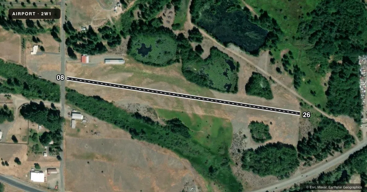
Airport sketch
Runways drawn to scale from FAA survey coordinates, rendered over satellite imagery. Not for navigation.
Approaches & charts
Services on the field
Fuel grades, oxygen, maintenance, ramp storage and lighting — as declared to the FAA by the airport operator.
Fuel & services
- Fuel
- Not available
- Oxygen (bottled)
- Not available
- Oxygen (bulk)
- Not available
Ramp & ground
- Transient storage
- Tie-down
- Landing fee
- No fee published
- Customs
- Not available
- Wind indicator
- Yes
- Segmented circle
- No
Fuel & FBOs
Cheapest 100LL and Jet A on the field and nearby. Always confirm with the FBO before taxi.
Airport notes
Surface conditions, obstructions, local procedures, lighting outages and other notes published with each FAA cycle.
General notes
- ALL PATTERNS TO THE SOUTH.
- FIELD OCNLY CLSD IN WINTER.
- WILDLIFE ON & INVOF RY.
- RWY 08/26 HAS 2 INCH DROPOFF ALONG ENTR RWY BOTH SIDES.
- FOR CD CTC SEATTLE ARTCC AT 253-351-3694.
Approach & departure obstructions
- 0810-15 FT BUSHES/TREES WI PRIM SFC; +2 FT FENCE AT THR MKD WITH COLORED CONES; +6 FT ROAD SIGN AT 44 FT FM THR, 72 FT RIGHT; ROAD AT 12 FT FM THR; TWO 4.5 FT SIGNS 60 FT FROM THR, ONE 34 FT R & ONE 36 FT L.
- 264 FT BRUSH AND TREES 39-200 FT FM THR.
- 08MRKGS FADED.
- 26MRKGS FADED.
- 08RWY 08/26 NSTD MRKGS. NO NRS, SMALL AND SQUARE AIMING POINTS PAINTED ON RWY ENDS.
Other notes
- ALL TFC PATS ARE ESTAB TO THE SOUTH.
- TRAFFIC PATTERN INDICATORS CO-LOCATED W/WIND TEE.
- TIE DOWNS PILOT PROVIDED
- WIND TEE & SOCK.
- MANAGERALSO 509-674-2933.
- 08/26SVR UNSEALED CRACKS AND JOINTS.
VFR map & nearby airports
VFR sectional. Tap any ICAO chip to open that airport.
Key facts · 2W1
Answer card- ICAO
- 2W1
- Name
- DE VERE FLD
- Location
- CLE ELUM, WASHINGTON
- Elevation
- 1,800 ft MSL
- Traffic pattern altitude
- 2,800 ft MSL (1,000 AGL)
- Control tower
- Non-towered (use CTAF)
- Total runways
- 1
- Longest runway
- 08/26 · 2,055 ft
- Published ILS approaches
- 0
- Published frequencies
- 1
- Magnetic variation
- 20°
- Current flight rules
- VFR
- Current wind
- 000° at 0 kt
- Favored runway now
- –
DE VERE FLD is in Cle Elum, Washington. The field elevation is 1,800 ft MSL. It has one runway. Runway 08/26 is 2,055 ft long with asphalt pavement. There is no control tower. CTAF is 122.9. No ILS approaches are published. The pattern altitude is not published, so use the standard 1,000 ft AGL for light piston traffic unless the current Chart Supplement says otherwise.
This is a small field with some real surface and obstacle issues to brief before you go. Published remarks note 10 to 15 ft bushes and trees within the primary surface near runway 08. There is also a 2 ft fence at the threshold marked with colored cones. Other nearby items include a road sign, a road close to the threshold and two more signs near the runway end. The runway has severe unsealed cracks and joints. Markings are faded on both runway ends. A 2 inch dropoff runs along both sides of the runway. Wildlife is also reported on and near the runway.
All traffic patterns are to the south. That matters for your arrival planning. The field is closed in winter only. Tie downs are pilot provided. For clearance delivery, contact Seattle ARTCC at 253-351-3694. If you need current operating details before departure, check the current FAA Chart Supplement or call the airport operator directly.