METAR & TAF 8S2
8S2 does not publish a METAR.
Showing the nearest reporting station: KEAT (PANGBORN MEML) · 13.3 NM away. Conditions at 8S2 may differ.
METAR · KEAT
Observed 12:55Z
KEAT 221255Z 27006KT 10SM CLR 22/11 A2994
- Wind
- 270° @ 6 kt
- Visibility
- 10 SM
- Temp / Dew
- 22°C / 11°C
- Altimeter
- 29.94 inHg
- Clouds
- CLR
- Density alt
- 1,879 ft
- Ceiling
- Unlimited
- Rules
- VFR
Airport info & contacts
Manager on record, flight service, ARTCC, attendance schedule and pattern altitude — published by the FAA and refreshed every 28 days.
Location
- From city
- 2 NM SW
- VFR sectional
- SEATTLE
- ARTCC
- ZSE · SEATTLE
- NOTAM facility
- SEA (NOTAM-D)
Airport manager
- Name
- GINA SMITH
- Phone
- (509) 782-3321
- Address
- 5500 AIRPORT ROAD, CASHMERE WA 98815
Flight service · Hours
- FSS SEA
- SEATTLE1-800-WX-BRIEF
- Attendance
- Unattended
Frequencies
Tap any row to copy the frequency to your clipboard.
Runways & pattern
Full pagePattern entry · RWY 25
LEFT TRAFFICRunway end performance
| End | TORA | TODA | ASDA | LDA | VGSI | Approach lights | Obstruction |
|---|---|---|---|---|---|---|---|
| 07 | — | — | — | — | — | — | 54', trees, 318' from thr, 107' R of cntrln, slope 2 |
| 25 | — | — | — | — | — | — | 50', trees, 524' from thr, 21' R of cntrln, slope 6 |
Declared distances in feet. TORA = takeoff run available, TODA = takeoff distance, ASDA = accelerate-stop, LDA = landing distance.
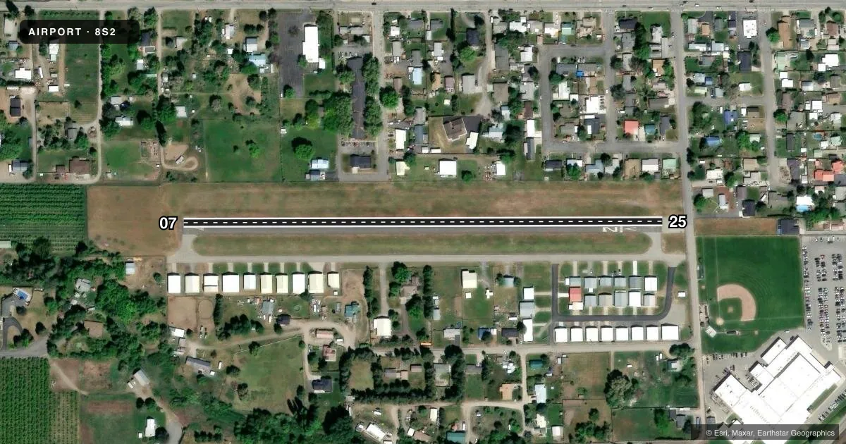
Airport sketch
Runways drawn to scale from FAA survey coordinates, rendered over satellite imagery. Not for navigation.
Approaches & charts
Services on the field
Fuel grades, oxygen, maintenance, ramp storage and lighting — as declared to the FAA by the airport operator.
Fuel & services
- Fuel
- Not available
- Oxygen (bottled)
- Not available
- Oxygen (bulk)
- Not available
- Airframe repair
- Not available
- Power plant repair
- Not available
Ramp & ground
- Transient storage
- Tie-down
- Landing fee
- No fee published
- Customs
- Not available
- Lighting schedule
- SEE RMK
- Beacon schedule
- SEE RMK
- Beacon
- White / Green (civil land)(WG)
- Wind indicator
- Lighted
- Segmented circle
- No
Fuel & FBOs
Cheapest 100LL and Jet A on the field and nearby. Always confirm with the FBO before taxi.
Airport notes
Surface conditions, obstructions, local procedures, lighting outages and other notes published with each FAA cycle.
General notes
- NUMEROUS OBJECTS IN TRANSITION SFCS.
- TREES IN PRIM SFC RY 07.
- EXIT RWY AT TWYS ONLY.
- GROUND VEHICLES AND PEDESTRIANS USE TWY FOR HANGAR ACCESS.
- RADIO CONTROL MODEL ACTIVITY PERMITTED, ON WEST END OF ARPT.
- FOR CD CTC SEATTLE ARTCC AT 253-351-3694.
Lighting notes
- ACTVT BCN - 121.7.
- ACTVT MIRL RWY 07/25 - 121.7.
Approach & departure obstructions
- 07RWY 07 +4 FT FENCE 100 FT L, FR 200-100 FT, ; +5 FT FENCE 109 FT R, FR 65-200 FT FR THR.
- 25+4 FT FENCE 90 FT, 40 FT L&R; ROAD AT 90 FT; 25-30 FT TREES AT 150 FT, 60 FT R; 3 FT SIGN AT 22 FT FM THR, 79 FT L.
- 25APCH SLOPE MEASURED FROM DSPLCD THR 28:1
Other notes
- ESTBD PRIOR TO MAY 1959.
- TIEDOWNS PILOT PROVIDED
VFR map & nearby airports
VFR sectional. Tap any ICAO chip to open that airport.
Key facts · 8S2
Answer card- ICAO
- 8S2
- Name
- CASHMERE-DRYDEN
- Location
- CASHMERE, WASHINGTON
- Elevation
- 857.6 ft MSL
- Traffic pattern altitude
- 1,857.6 ft MSL (1,000 AGL)
- Control tower
- Non-towered (use CTAF)
- Total runways
- 1
- Longest runway
- 07/25 · 1,800 ft
- Published ILS approaches
- 0
- Published frequencies
- 1
- Magnetic variation
- 20°
- Current flight rules
- VFR
- Current wind
- 270° at 6 kt
- Favored runway now
- RWY 25
Cashmere-Dryden Airport (8S2) sits in Cashmere, Washington. Field elevation is 857.6 ft MSL. The airport has one runway. Runway 07/25 is 1,800 ft long and asphalt. There is no control tower. CTAF is 122.9.
No ILS approaches are published here. Pattern altitude is not published in the chart data, so use standard light-piston pattern planning at 1,000 ft AGL unless the current FAA Chart Supplement says otherwise. That puts the pattern at about 1,857.6 ft MSL based on the field elevation. Medium intensity runway lights on 07/25 are activated on 121.7. The beacon is also on 121.7.
There are no on-field FBOs listed in the facts. Tiedowns are pilot provided. For clearance delivery, contact Seattle ARTCC at 253-351-3694. The runway has several published obstructions near both ends. Trees are also in the primary surface of runway 07. Exit the runway at taxiways only. Ground vehicles and pedestrians use taxiways for hangar access. This is a non-towered field with local traffic on CTAF, so a careful scan on final and after landing matters here.