METAR & TAF 80T
80T does not publish a METAR.
Showing the nearest reporting station: KEPH (EPHRATA MUNI) · 14.4 NM away. Conditions at 80T may differ.
METAR · KEPH
Observed 18:53Z
KEPH 261853Z AUTO 18013G19KT 10SM CLR 26/09 A2999 RMK AO2 SLP146 T02560094
- Wind
- 180° @ 13G19 kt
- Visibility
- 10 SM
- Temp / Dew
- 26°C / 9°C
- Altimeter
- 29.99 inHg
- Clouds
- CLR
- Density alt
- 2,809 ft
- Ceiling
- Unlimited
- Rules
- VFR
Airport info & contacts
Manager on record, flight service, ARTCC, attendance schedule and pattern altitude — published by the FAA and refreshed every 28 days.
Location
- From city
- 2 NM SE
- VFR sectional
- SEATTLE
- ARTCC
- ZSE · SEATTLE
- NOTAM facility
- SEA (NOTAM-D)
Airport manager
- Name
- PAT CONNELLY
- Phone
- 509-787-3715
- Address
- PORT OF QUINCY, 101 F STREET SW, QUINCY WA 98848
Flight service · Hours
- FSS SEA
- SEATTLE1-800-WX-BRIEF
- Attendance
- Unattended
Frequencies
Tap any row to copy the frequency to your clipboard.
Runways & pattern
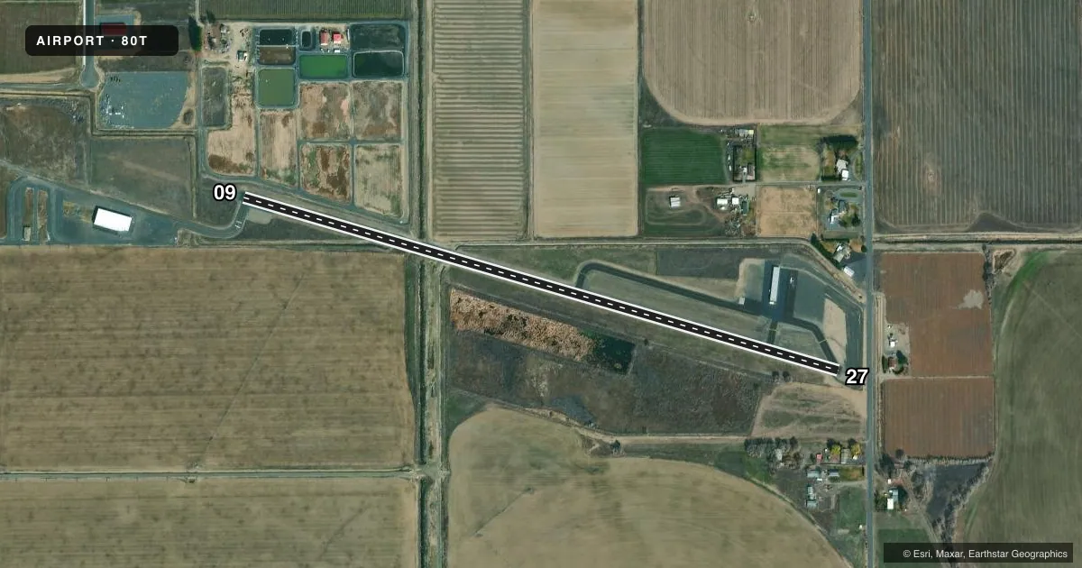
Full pagePattern entry · RWY 09
LEFT TRAFFICRunway end performance
| End | TORA | TODA | ASDA | LDA | VGSI | Approach lights | Obstruction |
|---|---|---|---|---|---|---|---|
| 09 | 3,460' | 3,460' | 3,660' | 3,660' | — | — | 18', road, 200' from thr, 48' R of cntrln, slope 1 |
| 27 | 3,660' | 3,660' | 3,460' | 3,460' | — | — | 54', tree, 340' from thr, 125' R of cntrln, slope 2 |
Declared distances in feet. TORA = takeoff run available, TODA = takeoff distance, ASDA = accelerate-stop, LDA = landing distance.
Airport sketch
Runways drawn to scale from FAA survey coordinates, rendered over satellite imagery. Not for navigation.
Approaches & charts
Services on the field
Fuel grades, oxygen, maintenance, ramp storage and lighting — as declared to the FAA by the airport operator.
Fuel & services
- Fuel
- Not available
- Oxygen (bottled)
- Not available
- Oxygen (bulk)
- Not available
- Airframe repair
- Not available
- Power plant repair
- Not available
Ramp & ground
- Transient storage
- Tie-down
- Landing fee
- No fee published
- Lighting schedule
- SS-SR
- Beacon schedule
- SS-SR
- Beacon
- White / Green (civil land)(WG)
- Wind indicator
- Lighted
- Segmented circle
- No
Fuel & FBOs
Cheapest 100LL and Jet A on the field and nearby. Always confirm with the FBO before taxi.
Airport notes
Surface conditions, obstructions, local procedures, lighting outages and other notes published with each FAA cycle.
General notes
- GRVL ROADS CROSS RY 27 2175' FM APCH END WHERE DITCHES PASS UNDER RY.
- BERMS, BRUSH, ROADS, FENCES AND -20 FT DITCHES IN PRIM SFC.
- TWYS MARKED WITH REFLECTIVE DEVICES.
- FOR CD CTC SEATTLE ARTCC AT 253-351-3694.
- 15 FT HI IRRIGATION PIVOT POINT W SIDE OF RWY, MID-FLD.
Approach & departure obstructions
- 27RWY 27 +4 FT FENCE AT 133 FT FM TRD; 4 FT FENCE, 101 FT L, EVEN WITH THR.
Other notes
- THIS AIRPORT HAS BEEN SURVEYED BY THE NATIONAL GEODETIC SURVEY.
- PILOTS BRING OWN ROPES.
- OWNERLESSOR: GRANT CO PORT DIST NO 1.
VFR map & nearby airports
VFR sectional. Tap any ICAO chip to open that airport.
Key facts · 80T
Answer card- ICAO
- 80T
- Name
- QUINCY MUNI
- Location
- QUINCY, WASHINGTON
- Elevation
- 1,271.1 ft MSL
- Traffic pattern altitude
- 2,271.1 ft MSL (1,000 AGL)
- Control tower
- Non-towered (use CTAF)
- Total runways
- 1
- Longest runway
- 09/27 · 3,660 ft
- Published ILS approaches
- 0
- Published frequencies
- 1
- Magnetic variation
- 20°
- Current flight rules
- VFR
- Current wind
- 180° at 13 kt
- Favored runway now
- RWY 09
Quincy Muni (80T) is in Quincy, Washington. The field elevation is 1,271.1 ft MSL. It has one runway. Runway 09/27 is 3,660 ft long and asphalt. There is no control tower. CTAF is 122.9. No ILS approaches are published here.
The pattern altitude is not published in the facts. Use the standard 1,000 ft AGL unless the current Chart Supplement says otherwise. That puts the light aircraft pattern at about 2,271 ft MSL based on the listed field elevation. The airport sits in a high-desert style operating environment with several surface hazards called out in the remarks. Berms, brush, roads, fences and 20-foot ditches are in the primary surface. Runway 27 also has fence obstructions near the threshold. There is a 15-foot irrigation pivot point on the west side of the runway near mid-field. Gravel roads cross runway 27 farther out on the approach end.
No on-field FBOs are listed, so plan on confirming services with the airport operator or calling the field on CTAF before arrival. The remarks also say pilots bring their own ropes. If you need clearance delivery, contact Seattle ARTCC at 253-351-3694. This is a non-towered field. Expect self-announced traffic and keep a close eye out for the published surface hazards.