METAR & TAF W20
W20 does not publish a METAR.
Showing the nearest reporting station: KMWH (GRANT COUNTY INTL) · 5.2 NM away. Conditions at W20 may differ.
METAR · KMWH
Observed 15:52Z
KMWH 261552Z 22004KT 10SM CLR 21/10 A3002 RMK AO2 SLP159 T02060100
- Wind
- 220° @ 4 kt
- Visibility
- 10 SM
- Temp / Dew
- 21°C / 10°C
- Altimeter
- 30.02 inHg
- Clouds
- CLR
- Density alt
- 2,088 ft
- Ceiling
- Unlimited
- Rules
- VFR
Airport info & contacts
Manager on record, flight service, ARTCC, attendance schedule and pattern altitude — published by the FAA and refreshed every 28 days.
Location
- From city
- 2 NM NE
- VFR sectional
- SEATTLE
- ARTCC
- ZSE · SEATTLE
- NOTAM facility
- SEA (NOTAM-D)
Airport manager
- Name
- CITY MANAGER
- Phone
- 509-764-3713
- Address
- CITY HALL, P.O. BOX 1579, MOSES LAKE WA 98837
Flight service · Hours
- FSS SEA
- SEATTLE1-800-WX-BRIEF
- Attendance
- Unattended
Frequencies
Tap any row to copy the frequency to your clipboard.
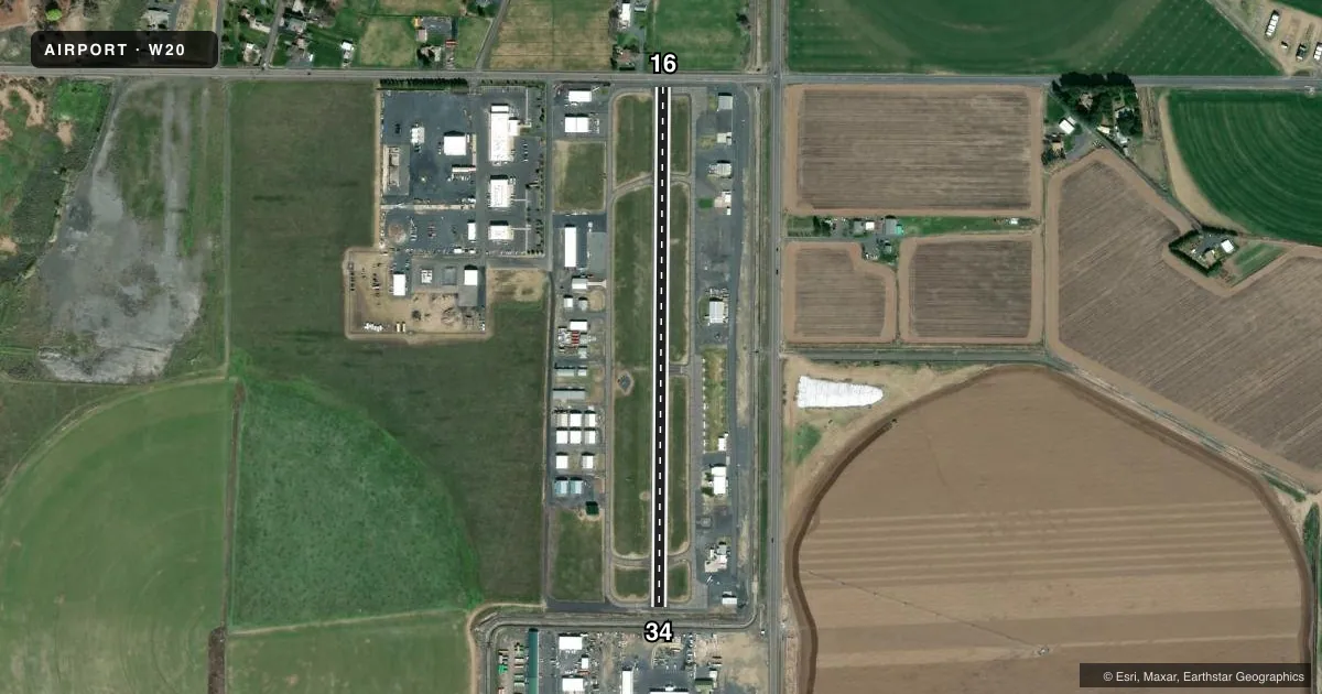
Runways & pattern
Full pagePattern entry · RWY 16
LEFT TRAFFICRunway end performance
| End | TORA | TODA | ASDA | LDA | VGSI | Approach lights | Obstruction |
|---|---|---|---|---|---|---|---|
| 16 | — | — | — | — | PAPI 2-box left(3°) | — | 83', tree, 1648' from thr, 119' R of cntrln, slope 17 |
| 34 | — | — | — | — | PAPI 2-box left(3°) | — | 22', bldg, 405' from thr, 0' R of cntrln, slope 9 |
Declared distances in feet. TORA = takeoff run available, TODA = takeoff distance, ASDA = accelerate-stop, LDA = landing distance.
Airport sketch
Runways drawn to scale from FAA survey coordinates, rendered over satellite imagery. Not for navigation.
Approaches & charts
Services on the field
Fuel grades, oxygen, maintenance, ramp storage and lighting — as declared to the FAA by the airport operator.
Fuel & services
- Fuel
- Not available
- Oxygen (bottled)
- Not available
- Oxygen (bulk)
- Not available
- Airframe repair
- Major
- Power plant repair
- Major
- Other services
- AGRI,INSTR,RNTL
Ramp & ground
- Transient storage
- Tie-down
- Landing fee
- No fee published
- Customs
- Not available
- Lighting schedule
- SS-SR
- Beacon schedule
- SS-SR
- Beacon
- White / Green (civil land)(WG)
- Wind indicator
- Lighted
- Segmented circle
- Yes
Fuel & FBOs
Cheapest 100LL and Jet A on the field and nearby. Always confirm with the FBO before taxi.
Airport notes
Surface conditions, obstructions, local procedures, lighting outages and other notes published with each FAA cycle.
General notes
- BIRD HAZARD.
- FOR CD CTC GRANT COUNTY APCH AT 509-762-2842, WHEN APCH CLSD CTC SEATTLE ARTCC AT 253-351-3694.
Approach & departure obstructions
- 1615 FT FM THR 4 FT FENCE, 25 FT FM THR ROAD; 80 FT FM THR 4 FT FENCE; 45 FT TREE, 125 FT R, 153 FT FR THLD; 23 FT TREE, 83 FT R, 176 FT FM THR.
- 34+5 FT EMBANKMENT, ROAD, CANAL, +4 FT FENCE 30 FT FM RWY END 200 FT L/R.
- 16APCH RATIO 13:1 FROM DSPLCD THR.
- 34APCH RATIO 49:1 TO +16 BLDG @ 773 FT FROM DSPLCD THR, 173R.
Other notes
- ESTABD PRIOR TO 15 MAY 1959.
- PILOTS BRING OWN ROPES
VFR map & nearby airports
VFR sectional. Tap any ICAO chip to open that airport.
Key facts · W20
Answer card- ICAO
- W20
- Name
- MOSES LAKE MUNI
- Location
- MOSES LAKE, WASHINGTON
- Elevation
- 1,203 ft MSL
- Traffic pattern altitude
- 2,203 ft MSL (1,000 AGL)
- Control tower
- Non-towered (use CTAF)
- Total runways
- 1
- Longest runway
- 16/34 · 2,513 ft
- Published ILS approaches
- 0
- Published frequencies
- 2
- Magnetic variation
- 19°
- Current flight rules
- VFR
- Current wind
- 220° at 4 kt
- Favored runway now
- RWY 16
MOSES LAKE MUNI is in Moses Lake, Washington. The field elevation is 1,203 ft MSL. It has one runway, 16/34, which is 2,513 ft long. There is no control tower. CTAF and UNICOM are both 123.0.
No ILS approaches are published here. The pattern altitude is not published, so use the standard 1,000 ft AGL for light piston operations unless the current FAA Chart Supplement says otherwise. That puts the traffic pattern at 2,203 ft MSL based on the field elevation. The runway is asphalt. Magnetic variation is 19°.
There are no on-field FBOs listed in the facts. Contact the airport operator directly before arrival. Call the field on CTAF/UNICOM for current FBO availability. Published remarks call out several obstructions near both runway ends. Runway 16 has fences, a road and trees close in. Runway 34 has an embankment, road, canal, fence and a building near the approach path. The remarks also note bird hazard. Pilots should plan for a short field with limited margin. The airport has been established since before 15 May 1959. Pilots must bring their own ropes.