METAR & TAF KEPH
Current METAR
Observed 02:53Z
KEPH 270253Z AUTO 24008KT 10SM CLR 29/07 A2989 RMK AO2 SLP114 T02890072 55004
- Wind
- 240° @ 8 kt
- Visibility
- 10 SM
- Temp / Dew
- 29°C / 7°C
- Altimeter
- 29.89 inHg
- Clouds
- CLR
- Density alt
- 3,300 ft
- Ceiling
- Unlimited
- Rules
- VFR
Airport info & contacts
Manager on record, flight service, ARTCC, attendance schedule and pattern altitude — published by the FAA and refreshed every 28 days.
Location
- From city
- 2 NM SE
- VFR sectional
- SEATTLE
- ARTCC
- ZSE · SEATTLE
- NOTAM facility
- EPH (NOTAM-D)
Airport manager
- Name
- DAVID LANMAN
- Phone
- 509-754-3508
- Address
- PO BOX 1089, EPHRATA WA 98823
Flight service · Hours
- FSS SEA
- SEATTLE1-800-WX-BRIEF
- Attendance
- MON-FRI · 0700-1600
Frequencies
Tap any row to copy the frequency to your clipboard.
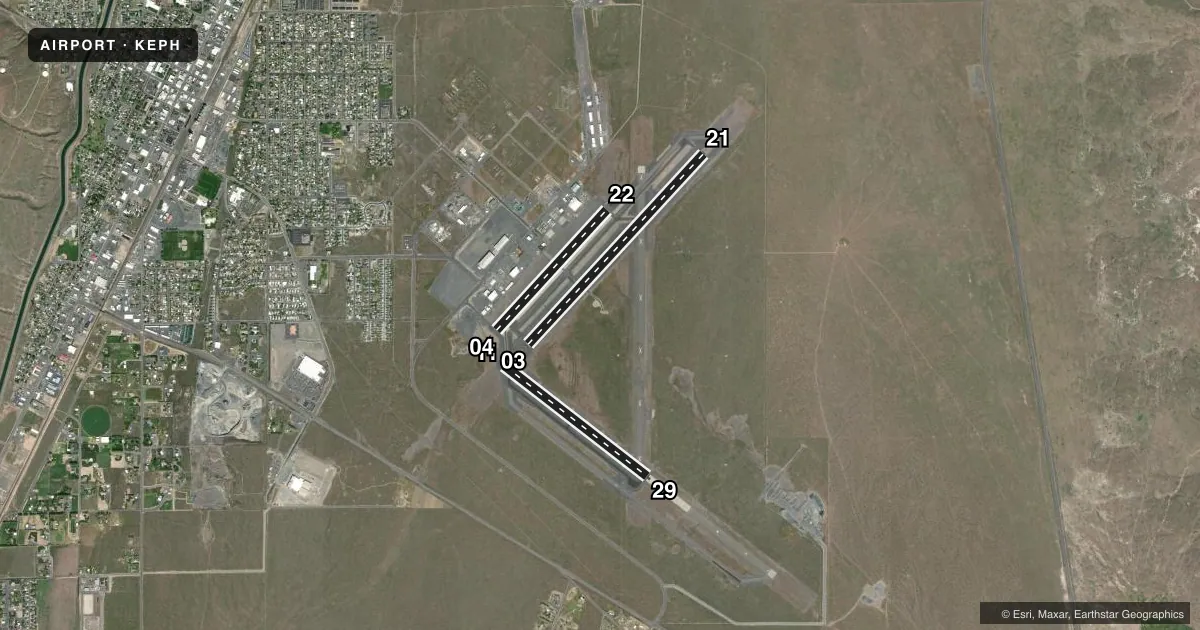
Runways & pattern
Full pagePattern entry · RWY 21
LEFT TRAFFIC| Runway | Heading (°M) | Length | Surface | Traffic |
|---|---|---|---|---|
| 03/21Favored | 27° / 207° | 5,500 ft | ASPH | 03 R |
| 11/29 | 112° / 292° | 3,843 ft | ASPH | Standard L |
| 04/22 | 26° / 206° | 3,467 ft | ASPH | 22 R |
Runway end performance
| End | TORA | TODA | ASDA | LDA | VGSI | Approach lights | Obstruction |
|---|---|---|---|---|---|---|---|
| 03 | — | — | — | — | PAPI 4-box left(3°) | — | 58', gnd, 2450' from thr, 550' R of cntrln, slope 38 |
| 21 | — | — | — | — | PAPI 4-box left(3°) | — | — |
| 11 | — | — | — | — | — | — | 52', gnd, 1666' from thr, 293' R of cntrln, slope 28 |
| 29 | — | — | — | — | PAPI 2-box left(3°) | — | — |
Declared distances in feet. TORA = takeoff run available, TODA = takeoff distance, ASDA = accelerate-stop, LDA = landing distance.
Airport sketch
Runways drawn to scale from FAA survey coordinates, rendered over satellite imagery. Not for navigation.
Approaches & charts
Services on the field
Fuel grades, oxygen, maintenance, ramp storage and lighting — as declared to the FAA by the airport operator.
Fuel & services
- Fuel
- 100LLAA+
- Oxygen (bottled)
- Not available
- Airframe repair
- Minor
- Power plant repair
- Minor
- Other services
- AGRI,GLD
Ramp & ground
- Transient storage
- Tie-down
- Hangar
- Landing fee
- No fee published
- Customs
- Not available
- Lighting schedule
- SEE RMK
- Beacon schedule
- SS-SR
- Beacon
- White / Green (civil land)(WG)
- Wind indicator
- Lighted
- Segmented circle
- Yes
Fuel & FBOs
Cheapest 100LL and Jet A on the field and nearby. Always confirm with the FBO before taxi.
Airport notes
Surface conditions, obstructions, local procedures, lighting outages and other notes published with each FAA cycle.
General notes
- BE ALERT AEROBATIC ACFT ACTIVITY OVER CENTER OF AIRPORT.
- (E81) REFLECTORS ON PORTIONS OF TWYS.
- CONDS NOT MNT MON-FRI 1600-0700, CONDS NOT MNT SAT-SUN & HOLS 1600-0700.
- FOR CD IF UNA TO CTC ON FSS FREQ, CTC GRANT COUNTY APCH AT 509-762-2842. WHEN APCH CLSD CTC SEATTLE ARTCC AT 253-351-3694.
Lighting notes
- ACTVT REIL RWYS 3, 11, 21 & 29; MIRL RWY 03/21 & MIRL RWY 11/29 - CTAF. PAPI RWY 29, RWY 03 & RWY 21 OPR CONSLY.
Fuel notes
- 100LLFUEL 24 HR CREDIT CARD SVC AVBL.
- AJET-A AVBL SEVEN DAYS A WEEK 1500Z-2300Z.
- A+JET-A W/ ADDITIVE AVBL SEVEN DAYS A WEEK 1500Z-2300Z
Runway surface & condition
- 04/22RWY 04/22 GLDS USE 1 APR TO 1 NOV.
Other notes
- UNICOM MNTD INTMTLY.
VFR map & nearby airports
VFR sectional. Tap any ICAO chip to open that airport.
Key facts · KEPH
Answer card- ICAO
- KEPH
- Name
- EPHRATA MUNI
- Location
- EPHRATA, WASHINGTON
- Elevation
- 1,276.2 ft MSL
- Traffic pattern altitude
- 2,276.2 ft MSL (1,000 AGL)
- Control tower
- Non-towered (use CTAF)
- Total runways
- 3
- Longest runway
- 03/21 · 5,500 ft
- Published ILS approaches
- 0
- Published frequencies
- 4
- Magnetic variation
- 16°
- Current flight rules
- VFR
- Current wind
- 240° at 8 kt
- Favored runway now
- RWY 21
Ephrata Muni is in Ephrata, Washington. The field elevation is 1,276.2 ft MSL. It has three asphalt runways. The longest is 5,500 ft on 03/21. There is no control tower. CTAF and UNICOM are both 122.8. UNICOM is maintained intermittently. No ILS approaches are published here.
Pattern altitude is not published. Use the standard 1,000 ft AGL for light piston traffic unless the current Chart Supplement says otherwise. That puts the pattern at about 2,276 ft MSL based on the field elevation. Verify before flight if you need an exact local procedure. Grant County Approach uses 126.4 and 379.95. If you cannot reach Flight Service for clearance delivery, the published remarks say to contact Grant County Approach. When approach is closed, contact Seattle ARTCC.
The on-field FBO is Ephrata Municipal Airport. It carries 100LL, Jet-A and Jet-A with Prist. Fuel 24-hour credit card service is available. Runway lights and REILs are published on 03, 11, 21 and 29. PAPI is published on 29, 03 and 21. Be alert for aerobatic traffic over the center of the airport. Taxiway reflectors are also noted in the remarks. Runway 04/22 has a glideslope use note from April 1 to November 1. Check the current Chart Supplement before relying on that runway for an approach setup.