METAR & TAF S70
S70 does not publish a METAR.
Showing the nearest reporting station: KMWH (GRANT COUNTY INTL) · 26.7 NM away. Conditions at S70 may differ.
METAR · KMWH
Observed 11:52Z
KMWH 271152Z AUTO 14006KT 10SM CLR 14/10 A3000 RMK AO2 SLP151 T01390100 10222 20139 53010
- Wind
- 140° @ 6 kt
- Visibility
- 10 SM
- Temp / Dew
- 14°C / 10°C
- Altimeter
- 30.00 inHg
- Clouds
- CLR
- Density alt
- 1,205 ft
- Ceiling
- Unlimited
- Rules
- VFR
Airport info & contacts
Manager on record, flight service, ARTCC, attendance schedule and pattern altitude — published by the FAA and refreshed every 28 days.
Location
- From city
- 4 NM SE
- VFR sectional
- SEATTLE
- ARTCC
- ZSE · SEATTLE
- NOTAM facility
- SEA (NOTAM-D)
Airport manager
- Name
- CHRIS FAIX
- Phone
- (509) 761-1004
- Address
- 705 EAST HEMLOCK, OTHELLO WA 99344
Flight service · Hours
- FSS SEA
- SEATTLE1-800-WX-BRIEF
- Attendance
- Unattended
Frequencies
Tap any row to copy the frequency to your clipboard.
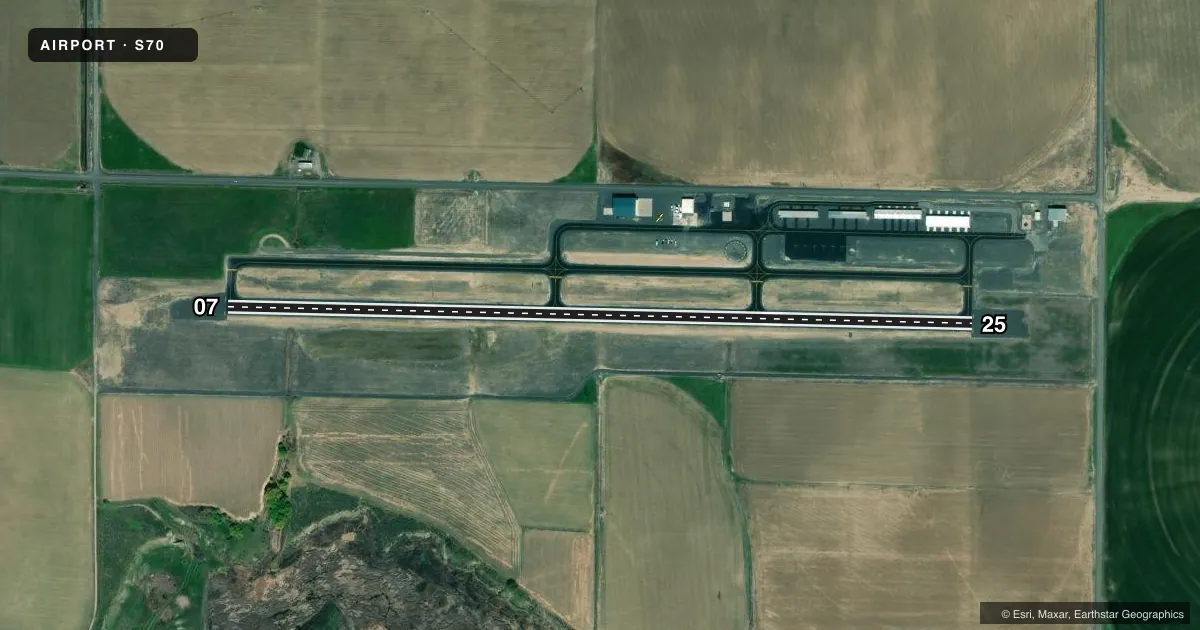
Runways & pattern
Full pagePattern entry · RWY 07
LEFT TRAFFICRunway end performance
| End | TORA | TODA | ASDA | LDA | VGSI | Approach lights | Obstruction |
|---|---|---|---|---|---|---|---|
| 07 | — | — | — | — | — | — | 15', road, 691' from thr, 0' R of cntrln, slope 32 |
| 25 | — | — | — | — | PAPI 2-box left(3°) | — | 15', road, 687' from thr, 0' R of cntrln, slope 32 |
Declared distances in feet. TORA = takeoff run available, TODA = takeoff distance, ASDA = accelerate-stop, LDA = landing distance.
Airport sketch
Runways drawn to scale from FAA survey coordinates, rendered over satellite imagery. Not for navigation.
Approaches & charts
Services on the field
Fuel grades, oxygen, maintenance, ramp storage and lighting — as declared to the FAA by the airport operator.
Fuel & services
- Fuel
- 100LL
- Oxygen (bottled)
- Not available
- Oxygen (bulk)
- Not available
- Airframe repair
- Not available
- Power plant repair
- Not available
- Other services
- AGRI
Ramp & ground
- Transient storage
- Tie-down
- Landing fee
- No fee published
- Customs
- Not available
- Lighting schedule
- SEE RMK
- Beacon schedule
- SS-SR
- Beacon
- White / Green (civil land)(WG)
- Wind indicator
- Lighted
- Segmented circle
- Yes
Fuel & FBOs
Cheapest 100LL and Jet A on the field and nearby. Always confirm with the FBO before taxi.
Airport notes
Surface conditions, obstructions, local procedures, lighting outages and other notes published with each FAA cycle.
General notes
- IRRIGATION PIVOT OCCASIONALLY OPRS ACROSS EXTENDED CTRLN OF RY 25, APPROXIMATELY 750 FT BYD RY END, DURING GROWING SEASON.
- FOR CD CTC GRANT COUNTY APCH AT 509-762-2842, WHEN APCH CLSD CTC SEATTLE ARTCC AT 253-351-3694.
Lighting notes
- ACTVT REIL RWY 07 & RWY 25; PAPI RWY 25; MIRL RWY 07/25 - CTAF.
Fuel notes
- 100LLFUEL AVBL 24 HRS.
Runway surface & condition
- 07/25PCR VALUE: 276/F/A/X/T
Other notes
- PILOTS BRING OWN ROPES.
VFR map & nearby airports
VFR sectional. Tap any ICAO chip to open that airport.
Key facts · S70
Answer card- ICAO
- S70
- Name
- OTHELLO MUNI
- Location
- OTHELLO, WASHINGTON
- Elevation
- 1,148.6 ft MSL
- Traffic pattern altitude
- 2,148.6 ft MSL (1,000 AGL)
- Control tower
- Non-towered (use CTAF)
- Total runways
- 1
- Longest runway
- 07/25 · 4,000 ft
- Published ILS approaches
- 0
- Published frequencies
- 1
- Magnetic variation
- 19°
- Current flight rules
- VFR
- Current wind
- 140° at 6 kt
- Favored runway now
- RWY 07
Othello Muni (S70) sits in Othello, Washington. Field elevation is 1,148.6 ft MSL. The airport has one runway, 07/25, which is 4,000 ft long and paved with asphalt. There is no control tower. CTAF is 122.9.
No ILS approaches are published here. The pattern altitude is not published, so use standard 1,000 ft AGL unless the current Chart Supplement says otherwise. The published lighting is useful for night work. Runway end identifier lights are installed on both ends. Medium intensity runway lights are installed on 07 and 25. A PAPI is installed on runway 25.
Othello Municipal Airport is the on-field FBO. It carries 100LL. Fuel is available 24 hours. Pilots should also note the published clearance delivery contact for Grant County Approach at 509-762-2842. When approach is closed, Seattle ARTCC is listed at 253-351-3694. The remarks also say to bring your own ropes. An irrigation pivot can occasionally cross the extended centerline for runway 25 about 750 ft beyond the departure end during the growing season. The pavement classification rating is 276/F/A/X/T.