METAR & TAF W09
W09 does not publish a METAR.
Showing the nearest reporting station: KALW (WALLA WALLA RGNL) · 29.4 NM away. Conditions at W09 may differ.
METAR · KALW
Observed 12:53Z
KALW 271253Z 17003KT 10SM CLR 18/04 A3004 RMK AO2 SLP163 T01780039
- Wind
- 170° @ 3 kt
- Visibility
- 10 SM
- Temp / Dew
- 18°C / 4°C
- Altimeter
- 30.04 inHg
- Clouds
- CLR
- Density alt
- 1,219 ft
- Ceiling
- Unlimited
- Rules
- VFR
Airport info & contacts
Manager on record, flight service, ARTCC, attendance schedule and pattern altitude — published by the FAA and refreshed every 28 days.
Location
- From city
- 5 NM S
- VFR sectional
- SEATTLE
- ARTCC
- ZSE · SEATTLE
- NOTAM facility
- SEA (NOTAM-D)
Airport manager
- Name
- WSDOT AVIATION DIVISION
- Phone
- 800-552-0666
- Address
- 7702 TERMINAL STREET SW, TUMWATER WA 98501
Flight service · Hours
- FSS SEA
- SEATTLE1-800-WX-BRIEF
- Attendance
- Unattended
Frequencies
Tap any row to copy the frequency to your clipboard.
Runways & pattern
Full pagePattern entry · RWY 19
RIGHT TRAFFICRunway end performance
| End | TORA | TODA | ASDA | LDA | VGSI | Approach lights | Obstruction |
|---|---|---|---|---|---|---|---|
| 01 | — | — | — | — | — | — | 680', tower, 6800' from thr, 0' R of cntrln, slope 10 |
| 19 | — | — | — | — | — | — | 115', pline, 2300' from thr, 0' R of cntrln, slope 20 |
Declared distances in feet. TORA = takeoff run available, TODA = takeoff distance, ASDA = accelerate-stop, LDA = landing distance.
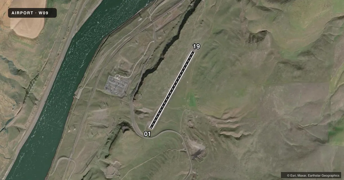
Airport sketch
Runways drawn to scale from FAA survey coordinates, rendered over satellite imagery. Not for navigation.
Approaches & charts
Services on the field
Fuel grades, oxygen, maintenance, ramp storage and lighting — as declared to the FAA by the airport operator.
Fuel & services
- Fuel
- Not available
- Oxygen (bottled)
- Not available
- Oxygen (bulk)
- Not available
- Airframe repair
- Not available
- Power plant repair
- Not available
Ramp & ground
- Transient storage
- Tie-down
- Landing fee
- No fee published
- Wind indicator
- Yes
- Segmented circle
- No
Fuel & FBOs
Cheapest 100LL and Jet A on the field and nearby. Always confirm with the FBO before taxi.
Airport notes
Surface conditions, obstructions, local procedures, lighting outages and other notes published with each FAA cycle.
General notes
- MULTIPLE POWERLINES 0.4 MILE NNE OF AIRPORT.
- VEHICLES; PEDESTRIANS, AND ANIMALS ON & INOV RY.
- FOR CD CTC CHINOOK APCH AT 509-542-4209, WHEN APCH CLSD CTC SEATTLE ARTCC AT 253-351-3694.
- NO WINTER SNOW REMOVAL OPS.
Other notes
- PRVDD THE FOLLOWING APPEARS IN TH AIM; MULTIPLE POWER LINES 0.4 MI NNE OF ARPT. CAUTION; RWY ROUGH; ROCK SURFACE.
- PILOTS PROVD OWN TIEDOWN CHAINS.
- MANAGEROTR CTC: AVIATION@WSDOT.WA.GOV
- OWNEROTR CTC: EMAIL AVIATION@WSDOT.WA.GOV
- 01/19GRVL PTNS OF RWY ABNDT OF WEEDS AND SFC ROUGH AND SOFT.
- 01/19RWY 01/19 RWY SURFACE EMULSION LAYER CRUMBLES.
VFR map & nearby airports
VFR sectional. Tap any ICAO chip to open that airport.
Key facts · W09
Answer card- ICAO
- W09
- Name
- LOWER MONUMENTAL STATE
- Location
- KAHLOTUS, WASHINGTON
- Elevation
- 813 ft MSL
- Traffic pattern altitude
- 1,813 ft MSL (1,000 AGL)
- Control tower
- Non-towered (use CTAF)
- Total runways
- 1
- Longest runway
- 01/19 · 3,300 ft
- Published ILS approaches
- 0
- Published frequencies
- 1
- Magnetic variation
- 19°
- Current flight rules
- VFR
- Current wind
- 170° at 3 kt
- Favored runway now
- RWY 19
Lower Monumental State Airport is in Kahlotus, Washington. The field elevation is 813 ft MSL. It has one runway, 01/19, which is 3,300 ft long and gravel. There is no control tower. CTAF is 122.9.
No ILS approaches are published here. Pattern altitude is not published, so use the standard 1,000 ft AGL for light piston operations unless current published guidance says otherwise. The runway headings are magnetic. Runway 01/19 is listed with rough surface conditions. The published remarks also note an emulsion layer that crumbles. They also mention abandoned weeds in gravel portions. Soft spots are part of the picture too. That is not a place to assume normal braking or rollout.
The airport remarks also call out multiple power lines about 0.4 mile north-northeast of the field. Vehicles, pedestrians and animals may be on or near the runway. No winter snow removal operations are provided. There are no on-field FBOs listed, so plan to verify support before you go. For clearance delivery, contact Chinook Approach at 509-542-4209. If approach is closed, contact Seattle ARTCC at 253-351-3694. Pilots should check the current FAA Chart Supplement for any additional operating notes before flying in.