METAR & TAF 0S0
0S0 does not publish a METAR.
Showing the nearest reporting station: KMWH (GRANT COUNTY INTL) · 33.0 NM away. Conditions at 0S0 may differ.
METAR · KMWH
Observed 05:52Z
KMWH 270552Z AUTO 30007KT 10SM CLR 22/05 A2995 RMK AO2 SLP136 T02220050 10311 20211 53018
- Wind
- 300° @ 7 kt
- Visibility
- 10 SM
- Temp / Dew
- 22°C / 5°C
- Altimeter
- 29.95 inHg
- Clouds
- CLR
- Density alt
- 2,671 ft
- Ceiling
- Unlimited
- Rules
- VFR
Airport info & contacts
Manager on record, flight service, ARTCC, attendance schedule and pattern altitude — published by the FAA and refreshed every 28 days.
Location
- From city
- 2 NM NE
- VFR sectional
- SEATTLE
- ARTCC
- ZSE · SEATTLE
- NOTAM facility
- SEA (NOTAM-D)
Airport manager
- Name
- GLENN ABY
- Phone
- 509-660-0874
- Address
- PO BOX F, LIND WA 99341
Flight service · Hours
- FSS SEA
- SEATTLE1-800-WX-BRIEF
- Attendance
- Unattended
Frequencies
Tap any row to copy the frequency to your clipboard.
Runways & pattern
Full pagePattern entry · RWY 23
LEFT TRAFFICRunway end performance
| End | TORA | TODA | ASDA | LDA | VGSI | Approach lights | Obstruction |
|---|---|---|---|---|---|---|---|
| 23 | — | — | — | — | — | — | 17', hill, 902' from thr, 0' R of cntrln, slope 41 |
Declared distances in feet. TORA = takeoff run available, TODA = takeoff distance, ASDA = accelerate-stop, LDA = landing distance.
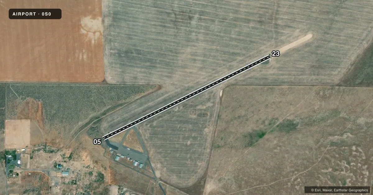
Airport sketch
Runways drawn to scale from FAA survey coordinates, rendered over satellite imagery. Not for navigation.
Approaches & charts
Services on the field
Fuel grades, oxygen, maintenance, ramp storage and lighting — as declared to the FAA by the airport operator.
Fuel & services
- Fuel
- Not available
- Oxygen (bottled)
- Not available
- Oxygen (bulk)
- Not available
- Airframe repair
- Not available
- Power plant repair
- Not available
- Other services
- AGRI
Ramp & ground
- Transient storage
- Tie-down
- Landing fee
- No fee published
- Customs
- Not available
- Lighting schedule
- SEE RMK
- Beacon schedule
- SS-SR
- Beacon
- White / Green (civil land)(WG)
- Wind indicator
- Lighted
- Segmented circle
- No
Fuel & FBOs
Cheapest 100LL and Jet A on the field and nearby. Always confirm with the FBO before taxi.
Airport notes
Surface conditions, obstructions, local procedures, lighting outages and other notes published with each FAA cycle.
General notes
- FOR CD CTC GRANT COUNTY APCH AT 509-762-2842, WHEN APCH CLSD CTC SEATTLE ARTCC AT 253-351-3694.
Lighting notes
- ACTVT HIRL RY 05/23 - CTAF
Runway surface & condition
- 05/23EAST END OF RY HAS 800 X 50' DIRT GRADED SAFETY AREA.
Approach & departure obstructions
- 05RY 05 +3' FENCE 100' FM THLD.
- 05MARKINGS FADED.
- 23MARKINGS FADED.
Other notes
- ESTABD PRIOR TO 15 MAY 1959.
- PILOTS BRING OWN TIEDOWNS.
VFR map & nearby airports
VFR sectional. Tap any ICAO chip to open that airport.
Key facts · 0S0
Answer card- ICAO
- 0S0
- Name
- LIND
- Location
- LIND, WASHINGTON
- Elevation
- 1,507 ft MSL
- Traffic pattern altitude
- 2,507 ft MSL (1,000 AGL)
- Control tower
- Non-towered (use CTAF)
- Total runways
- 1
- Longest runway
- 05/23 · 3,197 ft
- Published ILS approaches
- 0
- Published frequencies
- 1
- Magnetic variation
- 19°
- Current flight rules
- VFR
- Current wind
- 300° at 7 kt
- Favored runway now
- RWY 23
LIND sits in Washington at 1,507 ft MSL. It has one runway, 05/23, which is 3,197 ft long and asphalt. There is no control tower. CTAF is 122.9. No ILS approaches are published here, so plan with that in mind if the weather is marginal.
The published pattern altitude is not given, so use the standard 1,000 ft AGL unless the current Chart Supplement says otherwise. That puts the light-aircraft pattern at 2,507 ft MSL based on the field elevation. For clearance delivery, contact Grant County Approach at 509-762-2842. When Approach is closed, contact Seattle ARTCC at 253-351-3694.
There are no on-field FBOs listed in the facts. Bring your own tiedowns. Runway 05/23 has high intensity lighting that is activated by CTAF. The runway markings on both ends are faded. Runway 05 also has a 3 ft fence 100 ft from the threshold. The east end of the runway has an 800 by 50 ft dirt graded safety area. This is a field where a careful preflight and a good look at the runway environment matter, especially if you are arriving at night or in lower visibility.