METAR & TAF 33S
33S does not publish a METAR.
Showing the nearest reporting station: KMWH (GRANT COUNTY INTL) · 38.3 NM away. Conditions at 33S may differ.
METAR · KMWH
Observed 09:52Z
KMWH 270952Z AUTO 19003KT 10SM CLR 17/08 A2997 RMK AO2 SLP143 T01720078
- Wind
- 190° @ 3 kt
- Visibility
- 10 SM
- Temp / Dew
- 17°C / 8°C
- Altimeter
- 29.97 inHg
- Clouds
- CLR
- Density alt
- 2,411 ft
- Ceiling
- Unlimited
- Rules
- VFR
Airport info & contacts
Manager on record, flight service, ARTCC, attendance schedule and pattern altitude — published by the FAA and refreshed every 28 days.
Location
- From city
- 1 NM W
- VFR sectional
- SEATTLE
- ARTCC
- ZSE · SEATTLE
- NOTAM facility
- SEA (NOTAM-D)
Airport manager
- Name
- DAVE BREAZEALE
- Phone
- 509-659-1930
- Address
- 216 E. MAIN, RITZVILLE WA 99169-1417
Flight service · Hours
- FSS SEA
- SEATTLE1-800-WX-BRIEF
- Attendance
- Unattended
Frequencies
Tap any row to copy the frequency to your clipboard.
Runways & pattern
Full pagePattern entry · RWY 19
LEFT TRAFFICRunway end performance
| End | TORA | TODA | ASDA | LDA | VGSI | Approach lights | Obstruction |
|---|---|---|---|---|---|---|---|
| 01 | 2,614' | 2,614' | 3,433' | 3,433' | PAPI 2-box left(4°) | — | 27', pline, 1282' from thr, 69' R of cntrln, slope 39 |
| 19 | 3,433' | 3,433' | 3,433' | 2,614' | PAPI 2-box right(3.5°) | — | 48', tree, 540' from thr, 32' R of cntrln, slope 7 |
Declared distances in feet. TORA = takeoff run available, TODA = takeoff distance, ASDA = accelerate-stop, LDA = landing distance.
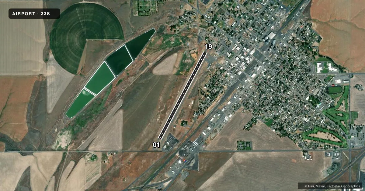
Airport sketch
Runways drawn to scale from FAA survey coordinates, rendered over satellite imagery. Not for navigation.
Approaches & charts
Services on the field
Fuel grades, oxygen, maintenance, ramp storage and lighting — as declared to the FAA by the airport operator.
Fuel & services
- Fuel
- Not available
- Oxygen (bottled)
- Not available
- Oxygen (bulk)
- Not available
- Airframe repair
- Not available
- Power plant repair
- Not available
- Other services
- AGRI
Ramp & ground
- Transient storage
- Tie-down
- Landing fee
- No fee published
- Customs
- Not available
- Lighting schedule
- SEE RMK
- Beacon schedule
- SS-SR
- Beacon
- White / Green (civil land)(WG)
- Wind indicator
- Lighted
- Segmented circle
- No
Fuel & FBOs
Cheapest 100LL and Jet A on the field and nearby. Always confirm with the FBO before taxi.
Airport notes
Surface conditions, obstructions, local procedures, lighting outages and other notes published with each FAA cycle.
General notes
- ARPT CLSD WHEN SNOW/ICE ON RY.
- FOR CD CTC GRANT COUNTY APCH AT 509-762-2842, WHEN APCH CLSD CTC SEATTLE ARTCC AT 253-351-3694.
Lighting notes
- ACTVT MIRL RY 01/19 AND PAPI RYS 01 & 19 - CTAF.
Approach & departure obstructions
- 19HOUSES, ROAD, SIGNS, AND TREES FM 0-200 FT OF THLD. 60 FT TREE 170 FT FM THLD, 70 FT RIGHT.
- 01MRKGS ARE FADED.
- 19MRKGS ARE FADED.
Other notes
- ESTABD PRIOR TO 15 MAY 1959.
- PILOTS BRING ROPES.
VFR map & nearby airports
VFR sectional. Tap any ICAO chip to open that airport.
Key facts · 33S
Answer card- ICAO
- 33S
- Name
- PRU FLD
- Location
- RITZVILLE, WASHINGTON
- Elevation
- 1,801 ft MSL
- Traffic pattern altitude
- 2,801 ft MSL (1,000 AGL)
- Control tower
- Non-towered (use CTAF)
- Total runways
- 1
- Longest runway
- 01/19 · 3,433 ft
- Published ILS approaches
- 0
- Published frequencies
- 2
- Magnetic variation
- 19°
- Current flight rules
- VFR
- Current wind
- 190° at 3 kt
- Favored runway now
- RWY 19
PRU FLD is in Ritzville, Washington. The field elevation is 1,801 ft MSL. It has one runway, 01/19, which is 3,433 ft long and asphalt. There is no control tower. CTAF and UNICOM are both 122.8. No ILS approaches are published here.
The pattern altitude is not published. Use the standard 1,000 ft AGL pattern unless local guidance says otherwise. That puts the pattern at 2,801 ft MSL based on the field elevation. The airport has no on-field FBOs listed, so plan ahead for services before you arrive. Published remarks also say runway 01 and runway 19 markings are faded. Pilots should bring ropes. Runway 19 has nearby houses, a road, signs and trees close to the threshold. There is also a 60-foot tree 170 ft from the threshold, 70 ft right of centerline.
This is a non-towered field with runway lights and PAPI on both ends. Use CTAF for light activation. For clearance delivery, contact Grant County Approach. If Approach is closed, contact Seattle ARTCC. The airport is closed when snow or ice is on the runway. Check the current FAA Chart Supplement before flying in if you need any current noise or operational notes.