METAR & TAF 2S4
2S4 does not publish a METAR.
Showing the nearest reporting station: KMWH (GRANT COUNTY INTL) · 17.9 NM away. Conditions at 2S4 may differ.
METAR · KMWH
Observed 21:52Z
KMWH 262152Z 21009KT 10SM CLR 29/07 A2995 RMK AO2 SLP135 T02890072
- Wind
- 210° @ 9 kt
- Visibility
- 10 SM
- Temp / Dew
- 29°C / 7°C
- Altimeter
- 29.95 inHg
- Clouds
- CLR
- Density alt
- 3,225 ft
- Ceiling
- Unlimited
- Rules
- VFR
Airport info & contacts
Manager on record, flight service, ARTCC, attendance schedule and pattern altitude — published by the FAA and refreshed every 28 days.
Location
- From city
- 1 NM W
- VFR sectional
- SEATTLE
- ARTCC
- ZSE · SEATTLE
- NOTAM facility
- SEA (NOTAM-D)
Airport manager
- Name
- PAT MILLARD
- Phone
- 509-750-4634
- Address
- PO BOX 841, 605 W 1ST ST., WARDEN WA 98857
Flight service · Hours
- FSS SEA
- SEATTLE1-800-WX-BRIEF
- Attendance
- Unattended
Frequencies
Tap any row to copy the frequency to your clipboard.
Runways & pattern
Full pagePattern entry · RWY 17
LEFT TRAFFICRunway end performance
| End | TORA | TODA | ASDA | LDA | VGSI | Approach lights | Obstruction |
|---|---|---|---|---|---|---|---|
| 17 | — | — | — | — | S2R 2-box right | — | 18', other, 327' from thr, 125' R of cntrln, slope 7 |
Declared distances in feet. TORA = takeoff run available, TODA = takeoff distance, ASDA = accelerate-stop, LDA = landing distance.
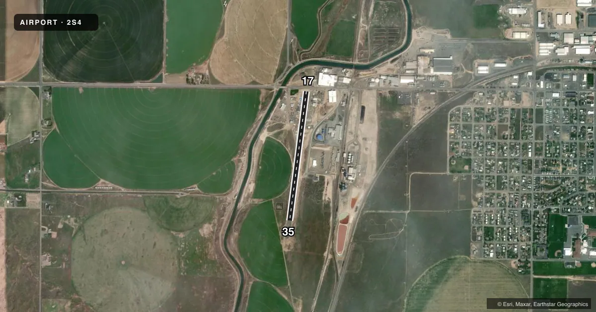
Airport sketch
Runways drawn to scale from FAA survey coordinates, rendered over satellite imagery. Not for navigation.
Approaches & charts
Services on the field
Fuel grades, oxygen, maintenance, ramp storage and lighting — as declared to the FAA by the airport operator.
Fuel & services
- Fuel
- Not available
- Oxygen (bottled)
- Not available
- Oxygen (bulk)
- Not available
- Airframe repair
- Not available
- Power plant repair
- Not available
- Other services
- AGRI
Ramp & ground
- Transient storage
- Tie-down
- Landing fee
- No fee published
- Customs
- Not available
- Lighting schedule
- SS-SR
- Beacon schedule
- SS-SR
- Beacon
- White / Green (civil land)(WG)
- Wind indicator
- Lighted
- Segmented circle
- No
Fuel & FBOs
Cheapest 100LL and Jet A on the field and nearby. Always confirm with the FBO before taxi.
Airport notes
Surface conditions, obstructions, local procedures, lighting outages and other notes published with each FAA cycle.
General notes
- FIRST 800 FT RY 35 SLOPES DOWN TO THE N 3 PERCENT.
- FENCES IN PRIM SFC RY 35.
- GRVL APRON COND GOOD.
- FOR CD CTC GRANT COUNTY APCH AT 509-762-2842, WHEN APCH CLSD CTC SEATTLE ARTCC AT 253-351-3694.
- ROADS PARL BOTH SIDES OF RWY
- CTN: STRUCTURES AND IRRIGATION MATERIAL IN PRI APCH SFCS.
Runway surface & condition
- 17/35RY 17/35 320 FT GRVL OVERRUN SOUTH END.
Approach & departure obstructions
- 17+5 FT ROAD 75FT; +10 FT SIGN 105 FT, 110 FT R; SVRL +5 FT SIGNS 58 FT FM RWY END & 66 FT L; 58 FT FM THR, 110 FT L, 15 FT PIPE ON GND; +8 FT SIGN, 58 FT FM THR, 95 FT L.
- 35+4 FT FENCE 0-100 FT, 55 FT L & 70 FT R; 15 FT ROAD, 66 FT L, 0 TO 200 FT FM RWY END; 4 FT STAKE, 26 FT R, 67 FT FM THR; 16 FT IRRIGATION PIVOT POINT, 125 FT L, 162 FT FM THR.
- 17RWY 17/35 CENTERLINE PAINT CHIPPING.
- 17RWY 17 HAS SOLID CENTERLINE STRIPE ONLY.
- 35SOLID CENTERLINE - NO RUNWAY NUMBERS
- 17APCH RATIO 20:1 TO POLE 665' FM DSPLCD THR.
- 17AGRICULTURAL PROCESSING STRUCTURE.
Other notes
- RECORDS INDICATE SPONSOR DID NOT COMPLY WITH FAR PART 157.
- PILOTS BRING OWN ROPES.
VFR map & nearby airports
VFR sectional. Tap any ICAO chip to open that airport.
Key facts · 2S4
Answer card- ICAO
- 2S4
- Name
- WARDEN
- Location
- WARDEN, WASHINGTON
- Elevation
- 1,276 ft MSL
- Traffic pattern altitude
- 2,276 ft MSL (1,000 AGL)
- Control tower
- Non-towered (use CTAF)
- Total runways
- 1
- Longest runway
- 17/35 · 2,811 ft
- Published ILS approaches
- 0
- Published frequencies
- 1
- Magnetic variation
- 19°
- Current flight rules
- VFR
- Current wind
- 210° at 9 kt
- Favored runway now
- RWY 17
Warden Airport sits in Warden, Washington. The field elevation is 1,276 ft MSL. It has one runway, 17/35, which is 2,811 ft long on asphalt. There is no control tower. CTAF is 122.9. No ILS approaches are published here.
The pattern altitude is not published. Use the current FAA Chart Supplement before you go. If no special pattern is listed, standard light aircraft pattern altitude is 1,000 ft AGL. That would put you at 2,276 ft MSL here, but verify the published pattern before departure. There are no on-field FBOs listed, so plan on coordinating services with the airport operator or by calling ahead.
A few remarks matter for a first-time arrival. The first 800 ft of runway 35 slopes down to the north at 3 percent. Runway 17/35 also has a 320 ft gravel overrun on the south end. There are roads parallel to both sides of the runway. There are fences in the primary surface for runway 35. The field also has obstructions near runway 17. Clearance delivery for IFR coordination goes through Grant County Approach when it is open. When Approach is closed, Seattle ARTCC is the contact. Expect a small, non-towered field with local hazards close to the runway edges.