METAR & TAF 43D
43D does not publish a METAR.
Showing the nearest reporting station: KMWH (GRANT COUNTY INTL) · 27.4 NM away. Conditions at 43D may differ.
METAR · KMWH
Observed 12:52Z
KMWH 271252Z 11003KT 10SM CLR 13/10 A3001 RMK AO2 SLP155 T01330100
- Wind
- 110° @ 3 kt
- Visibility
- 10 SM
- Temp / Dew
- 13°C / 10°C
- Altimeter
- 30.01 inHg
- Clouds
- CLR
- Density alt
- 1,803 ft
- Ceiling
- Unlimited
- Rules
- VFR
Airport info & contacts
Manager on record, flight service, ARTCC, attendance schedule and pattern altitude — published by the FAA and refreshed every 28 days.
Location
- From city
- 1 NM N
- VFR sectional
- SEATTLE
- ARTCC
- ZSE · SEATTLE
- NOTAM facility
- SEA (NOTAM-D)
Airport manager
- Name
- STAN DAMMEL
- Phone
- 509-660-3024
- Address
- P.O. BOX 186, ODESSA WA 99159
Flight service · Hours
- FSS SEA
- SEATTLE1-800-WX-BRIEF
- Attendance
- Unattended
Frequencies
Tap any row to copy the frequency to your clipboard.
Runways & pattern
Full pagePattern entry · RWY 02
LEFT TRAFFICRunway end performance
| End | TORA | TODA | ASDA | LDA | VGSI | Approach lights | Obstruction |
|---|---|---|---|---|---|---|---|
| 02 | — | — | — | — | PAPI 2-box left(3.5°) | — | — |
| 20 | — | — | — | — | PAPI 2-box left(3°) | — | — |
Declared distances in feet. TORA = takeoff run available, TODA = takeoff distance, ASDA = accelerate-stop, LDA = landing distance.
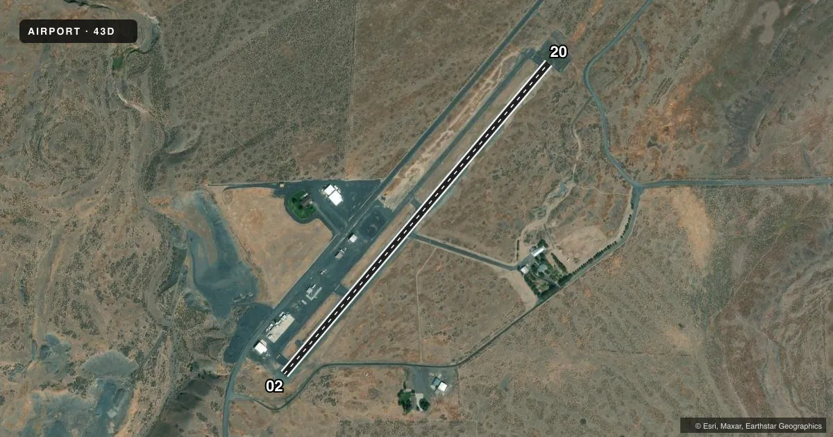
Airport sketch
Runways drawn to scale from FAA survey coordinates, rendered over satellite imagery. Not for navigation.
Approaches & charts
Services on the field
Fuel grades, oxygen, maintenance, ramp storage and lighting — as declared to the FAA by the airport operator.
Fuel & services
- Fuel
- Not available
- Oxygen (bottled)
- Not available
- Oxygen (bulk)
- Not available
- Airframe repair
- Not available
- Power plant repair
- Not available
- Other services
- AGRI
Ramp & ground
- Transient storage
- Tie-down
- Landing fee
- No fee published
- Customs
- Not available
- Lighting schedule
- SS-SR
- Beacon schedule
- SS-SR
- Beacon
- White / Green (civil land)(WG)
- Wind indicator
- Lighted
- Segmented circle
- No
Fuel & FBOs
Cheapest 100LL and Jet A on the field and nearby. Always confirm with the FBO before taxi.
Airport notes
Surface conditions, obstructions, local procedures, lighting outages and other notes published with each FAA cycle.
General notes
- DEER INVOF OF RUNWAY.
- FOR CD CTC GRANT COUNTY APCH AT 509-762-2842, WHEN APCH CLSD CTC SEATTLE ARTCC AT 253-351-3694.
Other notes
- ESTABLISHED PRIOR 1959
- PILOTS BRING OWN ROPES.
VFR map & nearby airports
VFR sectional. Tap any ICAO chip to open that airport.
Key facts · 43D
Answer card- ICAO
- 43D
- Name
- ODESSA MUNI
- Location
- ODESSA, WASHINGTON
- Elevation
- 1,737.6 ft MSL
- Traffic pattern altitude
- 2,737.6 ft MSL (1,000 AGL)
- Control tower
- Non-towered (use CTAF)
- Total runways
- 1
- Longest runway
- 02/20 · 3,124 ft
- Published ILS approaches
- 0
- Published frequencies
- 1
- Magnetic variation
- 19°
- Current flight rules
- VFR
- Current wind
- 110° at 3 kt
- Favored runway now
- RWY 02
Odessa Muni sits in Odessa, Washington. The field elevation is 1,737.6 ft MSL. It has one runway. Runway 02/20 is 3,124 ft long with asphalt pavement. There is no control tower. CTAF is 122.9. No ILS approaches are published here.
The pattern altitude is not published. Use the standard 1,000 ft AGL pattern unless local traffic or the current Chart Supplement says otherwise. That puts the light piston pattern at about 2,738 ft MSL. For clearance delivery, contact Grant County Approach at 509-762-2842. When Approach is closed, contact Seattle ARTCC at 253-351-3694.
There are no on-field FBOs listed. Bring your own ropes since that is called out in the published remarks. Deer are in the vicinity of the runway, so keep a sharp scan on taxi, takeoff and landing. The airport is an older field. It was established prior to 1959. With the elevation here, expect some performance loss on warm days. Check density altitude before departure and plan accordingly.