METAR & TAF 68S
Current METAR
Observed 13:15Z
K68S 271315Z AUTO 17005KT 10SM CLR 11/04 A3005 RMK AO2 T01130037
- Wind
- 170° @ 5 kt
- Visibility
- 10 SM
- Temp / Dew
- 11°C / 4°C
- Altimeter
- 30.05 inHg
- Clouds
- CLR
- Density alt
- 2,365 ft
- Ceiling
- Unlimited
- Rules
- VFR
Airport info & contacts
Manager on record, flight service, ARTCC, attendance schedule and pattern altitude — published by the FAA and refreshed every 28 days.
Location
- From city
- 1 NM W
- VFR sectional
- SEATTLE
- ARTCC
- ZSE · SEATTLE
- NOTAM facility
- SEA (NOTAM-D)
Airport manager
- Name
- STEVE GOEMMEL
- Phone
- 509-725-4352
- Address
- P.O. BOX 26, DAVENPORT WA 99122
Flight service · Hours
- FSS SEA
- SEATTLE1-800-WX-BRIEF
- Attendance
- ON CALL
Frequencies
Tap any row to copy the frequency to your clipboard.
Runways & pattern
Full pagePattern entry · RWY 24
RIGHT TRAFFICRunway end performance
| End | TORA | TODA | ASDA | LDA | VGSI | Approach lights | Obstruction |
|---|---|---|---|---|---|---|---|
| 06 | — | — | — | — | PAPI 2-box left(4°) | — | — |
| 24 | — | — | — | — | PAPI 2-box left(4°) | — | — |
Declared distances in feet. TORA = takeoff run available, TODA = takeoff distance, ASDA = accelerate-stop, LDA = landing distance.
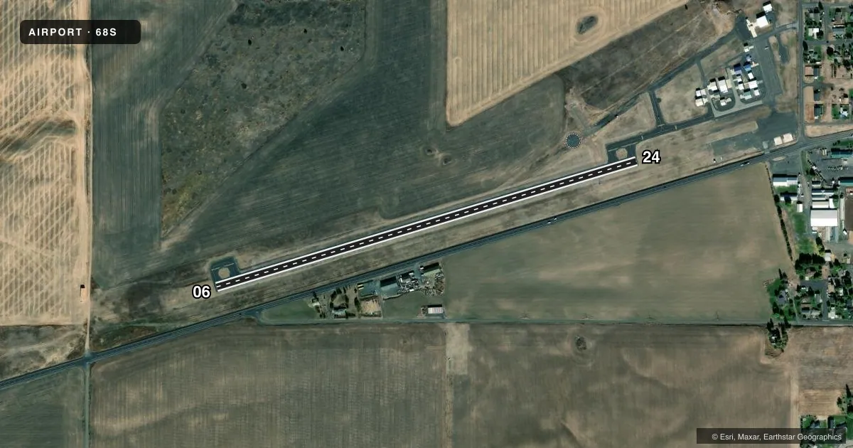
Airport sketch
Runways drawn to scale from FAA survey coordinates, rendered over satellite imagery. Not for navigation.
Approaches & charts
Services on the field
Fuel grades, oxygen, maintenance, ramp storage and lighting — as declared to the FAA by the airport operator.
Fuel & services
- Fuel
- 100LL
- Oxygen (bottled)
- Not available
- Oxygen (bulk)
- Not available
- Airframe repair
- Not available
- Other services
- AGRI,AMB
Ramp & ground
- Transient storage
- Tie-down
- Landing fee
- No fee published
- Customs
- Not available
- Lighting schedule
- SEE RMK
- Beacon schedule
- SS-SR
- Beacon
- White / Green (civil land)(WG)
- Wind indicator
- Lighted
- Segmented circle
- Yes
Fuel & FBOs
Cheapest 100LL and Jet A on the field and nearby. Always confirm with the FBO before taxi.
Airport notes
Surface conditions, obstructions, local procedures, lighting outages and other notes published with each FAA cycle.
General notes
- MON-FRI 8:00 AM TO 5:00 PM, CALL OFFICE NUMBER, 509-725-4352. AFTER HOURS CALL 509-721-0069.
- FOR CD CTC SPOKANE APCH AT 509-742-2522
Lighting notes
- MIRL RWY 06/24 ON SS-SR; PAPI RWY 06 AND 24 ON CONSLY.
Fuel notes
- 100LLFUEL 24 HR CREDIT CARD SVC AVBL.
Other notes
- ESTABD PRIOR TO 15 MAY 1959.
- PILOTS BRING OWN ROPES.
- MANAGERSGOEMMEL@DAVENPORTWA.US
VFR map & nearby airports
VFR sectional. Tap any ICAO chip to open that airport.
Key facts · 68S
Answer card- ICAO
- 68S
- Name
- DAVENPORT
- Location
- DAVENPORT, WASHINGTON
- Elevation
- 2,424.4 ft MSL
- Traffic pattern altitude
- 3,424.4 ft MSL (1,000 AGL)
- Control tower
- Non-towered (use CTAF)
- Total runways
- 1
- Longest runway
- 06/24 · 3,260 ft
- Published ILS approaches
- 0
- Published frequencies
- 1
- Magnetic variation
- 20°
- Current flight rules
- VFR
- Current wind
- 170° at 5 kt
- Favored runway now
- RWY 24
Davenport Airport (68S) sits in Davenport, Washington. The field elevation is 2,424.4 ft MSL. It has one runway. Runway 06/24 is 3,260 ft long and asphalt. There is no control tower, so use CTAF 122.9 and keep your scan tight in the pattern.
No ILS approaches are published here. Pattern altitude is not published, so use the standard 1,000 ft AGL for light piston aircraft unless the current Chart Supplement says otherwise. The runway lights on 06/24 are medium intensity from sunset to sunrise. PAPI is available on both ends.
Davenport Municipal Airport is the on-field FBO. It carries 100LL. Fuel is available with 24-hour credit card service. The published remarks also say pilots must bring their own ropes. That is worth planning for if you are tying down overnight.
This is a non-towered field in a high-elevation part of eastern Washington. Expect density altitude to matter on warm days. For clearance delivery, Spokane Approach is listed in the remarks. Check the current Chart Supplement for any local procedures before you go. The airport has been established since before 15 May 1959.